
Official websites use .gov
A .gov
website belongs to an official government organization in the
United States.
Secure .gov websites use HTTPS
A lock
(
) or https:// means you've safely
connected to the .gov website. Share sensitive information only
on official, secure websites.


This popular day-use area is the trailhead for several trails. While there is a permanent vault-type toilet installed here, there is no trash pickup. Please practice Leave No Trace principals and PACK IT IN, PACK IT OUT!
For maps of the area, see the following web pages:
At a Glance
| Current Conditions: | DAY USE ONLY! Camping is never allowed here - day use only. |
|---|---|
| Operational Hours: | Day-use only. No overnight camping allowed. |
| Open Season: | Year-round |
| Usage: | Medium-Heavy |
| Closest Towns: | Camp Verde, AZ |
| Water: | No |
| Restroom: | Vault Toilet |
| Operated By: | Red Rock District - 928-203-2900 |
General Information
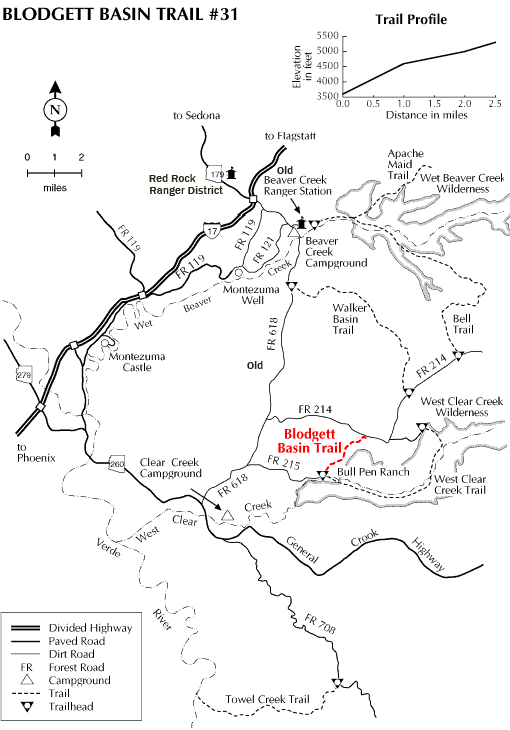
Directions:Location: 53 miles south of Flagstaff on paved and graveled forest roads in picturesque Desert Canyon Country.
GPS (Map): 34°32'23.7"N 111°42'23.8"W
Access: Take the Hwy. 179 exit on I-17. Drive about 9 miles from I-17 south-east on FR 618 to FR 215. Turn east and drive about 3 miles to the Bullpen Ranch trailhead. (See Blodgett Basin Trail map on this page)
General Notes:
Click map thumbnail for larger view (trail map also shows location of Bull Pen).
Activities
River and Stream Fishing
Day Hiking
Picnicking
Related Information

Location