
Sturgeon River Gorge Wilderness
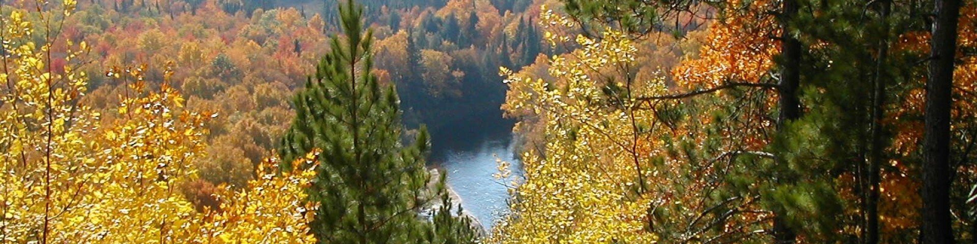
The Wild and Scenic Sturgeon River rushes out of the northern portion of this wilderness, over the 20-foot volcanic outcroppings of Sturgeon Falls, and through a gorge that reaches 350 feet in depth and a mile in width. Throughout this rugged, steep Wilderness, the Sturgeon and Little Silver Rivers and their tributaries have carved falls, rapids, ponds, oxbows, and terraces. Stunning views are possible from the eastern rim of the gorge. Except for a few naturally bare slopes, most of the land is forested with pine, hemlock, aspen, sugar maple, birch, and basswood. When the leaves of the hardwoods change color in the fall, they form a vivid tapestry. There are few established trails in Sturgeon River Gorge Wilderness, and the few overgrown logging roads are hard to find and follow. The North Country National Scenic Trail parallels the northern and eastern boundaries for about eight miles. Sturgeon River Campground offers seven sites on the southeastern boundary. In spring and during peak runoff, kayaking and white-water canoeing are challenging, and only recommended for advanced paddlers.


General Information
Campground Camping
The Sturgeon River Campground is located adjacent to the Wilderness on the Sturgeon River. This 7-site campground is a dispersed campground and no services are provided. This is an excellent location for those that want to get out an explore the wilderness and surrounding area.
- No. of Sites: 7
- Reservation Info: None
- No. of Accessible sites: 0
- Best Season: June-August
- Difficulty Level: Easy to Difficult
Dispersed Camping
If its solitude and pristine beauty you want combined with a challenge, you may want to camp in the Sturgeon River Gorge Wilderness. The Wilderness is managed to protect and maintain resources in natural states. They are not managed solely for recreational use by people. Few amenities are provided in the Wilderness, and users have a special responsibility to leave wilderness in a natural state. Campers should be prepared to pack in their water supply and pack out their trash. No waste disposal facilities or safe drinking water are available in these areas. Fires are permitted, but use of camp stoves is recommended for remote area camping. Low impact camping techniques that leave an area undisturbed after your passing are recommended. The Ottawa National Forest enforces a 16 day limit on camping sites. After 16 days, you must move to a new camping spot.
- Difficulty Level: Intermediate to Difficult
January 1 - December 31
This site is maintained from May 10 - October 31 but is open all year long.
No motorized vehicles of any kind are authorized within the Wilderness boundaries.
Overnight Use:
Single Site: $16 per night

Address: 4810 E. M28 Kenton, MI 49967
Phone: 906-852-3500
Hours: Monday - Friday, 8:00 a.m. - 4:00 p.m. (ET) (Closed on federal holidays)
Getting There
Latitude / Longitude
Latitude: 46.570096
Longitude: -88.65636953
Directions
Coming from the south from Sidnaw, travel east on M 28 approximately ¼ mile to FR 2200, turn left onto FR 2200. There are several locations to enter into the Wilderness, it is recommended that you use the campground or approved trailhead. To access the campground travel north on FR 2200 approximately 5 miles, the campground will be on your left. To access the southernmost trailhead, Sidnaw Creek Trail, travel north on FR 2200 approximately 3 miles to FR 2224 and turn left. Follow 2224 to the parking area. To access the northern most trail, Sturgeon Falls, turn south off of highway M38 onto Prickett Dam Rd., then at the fork turn right onto Forest Road 2270, after almost 10 miles the trailhead will be on your right with parking on the left.
Facility and Amenity Information
Restrooms
Restrooms are available at this site.
Water
Potable water is not available at this site.
Recreation Opportunities
Backpacking Info
There are few established trails in Sturgeon River Gorge Wilderness and the few old logging roads are overgrown and hard to follow. However, you can still enjoy the area while backpacking. The North Country Trail borders the wilderness on the north and east for about 8 miles. There are also several shorter trails that will allow you to enter into the wilderness and explore.
There are several trails that traverse the Sturgeon River Gorge Wilderness.
- Seasonal Information: The Wilderness and trails are open year-round, however snowfall can make travel very difficult. Please plan appropriately.
- Fire Information: No fires permitted
Day Hikes Info
There are several trails located within the boundaries of the Sturgeon River Gorge Wilderness that will allow you to explore deep into the Wilderness.
- Fire Information: No fires permitted
- Best Season: June-September
- Difficulty Level: Intermediate to Difficult
Viewing Scenery Info
The Wild and Scenic Sturgeon River rushes out of the northern portion of this wilderness, over the 20-foot volcanic outcroppings of Sturgeon Falls, and through a gorge that reaches 350 feet in depth and a mile in width. Throughout this rugged, steep Wilderness, the Sturgeon and Little Silver Rivers and their tributaries have carved falls, rapids, ponds, oxbows, and terraces. Stunning views are possible from the eastern rim of the gorge. Except for a few naturally bare slopes, most of the land is forested with pine, hemlock, aspen, sugar maple, birch, and basswood. When the leaves of the hardwoods change color in the fall, they form a vivid tapestry. There are few established trails in Sturgeon River Gorge Wilderness, and the few overgrown logging roads are hard to find and follow. The North Country National Scenic Trail parallels the northern and eastern boundaries for about eight miles. Sturgeon River Campground offers seven sites on the southeastern boundary. In spring and during peak runoff, kayaking and white-water canoeing are challenging, and only recommended for advanced paddlers.
- Special Feature: Viewing the Gorge in the fall provides a wonderful view of the fall colors of the Western UP.
- Difficulty Level: Intermediate to Difficult