
Lake Ottawa Recreation Area
Lake Ottawa Recreation area is in a beautiful forested northwoods setting located 5 miles southwest of Iron River, MI, on the Iron River Ranger District. Located in the general area is Lake Ottawa, Brule Lake, Hagerman Lake, Brule River, Bass Lake, the Historic Mile Post Zero/Treaty Tree, The Ge-Che Trail, and miles of hiking trails. Lake Ottawa Campground is 95% surrounded by National Forest System Lands and offers a pavilion with two stone fireplaces and original log picnic tables, and two log toilet buildings, which were constructed by the CCC in the late 1930's. A pressurized water system and sewage dump station is located in the campground. Adjacent to the campground is the CCC era , Lake Ottawa Day Use Facility with flush toilets, picnic areas, and a boat launch.
Fish Your National Forests: This site can be accessed by passenger car; fish available include, Lake trout, bass (Catch and release only, no possession allowed), walleye, panfish; Types of fishing available include shore, motorized boat, float tube, fly, spin, bait, ice; and boat launch available. Be sure to reference the latest Michigan fishing guide.


Reservations
Make Reservations HereReservations are accepted for 16 sites. Fifteen (15) first-come, first-served sites are also available.
- Reservations can be made up to 6 months in advance of visit.
- Reservations must be made at least 3 days in advance of visit.
- Go to: Recreation.gov or call 1-877-444-6777 to make a reservation.
General Information
Lake Ottawa Recreation area is in a beautiful forested Northwoods setting located 5 miles southwest of Iron River, MI., on the Iron River Ranger District. Located in the general area is Lake Ottawa, Brule Lake, Hagerman Lake, Brule River, Bass Lake, the Historic Mile Post Zero/Treaty Tree, The Ge-Che Trail, and miles of hiking trails. Lake Ottawa Campground offers a pavilion with two stone fireplaces and original log picnic tables, a pressurized water system and sewage dump station, and two log toilet buildings with flush toilets. The Pavilion and log toilet buildings were all constructed by the CCC in the late 1930’s. Adjacent to the campground is a boat launch, picnic areas, and a CCC era day use recreation building with flush toilets, and fireplace (this building is currently closed pending repairs).
Seasonal Information
The campground is scheduled to open with full services the Friday before Memorial Day. This date is subject to change, please contact the Watersmeet – Iron River Ranger District at 906-358-4551 for additional information.
- No. of Sites: 32
- Fire Information: Yes, in Fire Rings
- No. of Accessible sites: None
- Sleeping Shelter: No
Campground:
- The campground will close on September 30, 2024.
Day Use:
- The pavilion will remain closed.
- Day use fees are in place until September 30th.
- The day use area is open year-round, however services are reduced, and winter access can be limited due to snow plowing.
24 hours/ day
Golden Age/Interagency Senior and Access Passes Accepted
Camping in a developed recreation site is allowed for a period not longer than 14 days, except as otherwise posted. After this time, you must move to another campground or dispersed site for at least 24 hours. Campers must occupy the site the first night. Eight people and 2 motorized vehicles are allowed per campsite with a maximum of one RV or camper trailer and two tents per camping site or three tents per camping site.
Overnight Use:
Single Site: $22 per night
Day use/boat launch - $5/vehicle/day or $30/vehicle/season
Day use fees will not be charged to those who have already paid for a campground campsite.

Address: E23979 US 2 East Watersmeet, MI 49969
Phone: 906-358-4551
Hours: Monday - Friday, 8:00 a.m. - 4:00 p.m. (CT) (Closed on federal holidays)
Getting There
Latitude / Longitude
Latitude: 46.0807608
Longitude: -88.76003616
Directions
From Iron River, Mi., travel west on US 2, turn south on M 73, travel approximately 3/4 mile, turn west on Lake Ottawa Road and travel approximately 4 miles to the campground.
From Watersmeet, Mi., travel 28 miles east on US 2, turn south on M 73, travel approximately 3/4 mile, turn west on Lake Ottawa Road and travel approximately 4 miles to the campground.
Closest Towns: Iron River, Michigan 5 miles to the east.
Parking
Large Parking area near the Day Use Building, at the Boat Landing Parking Lot, and a 3-vehicle parking area is available in the campground.
Facility and Amenity Information
Restrooms
Restrooms are available at this site.
Water
Potable water is available at this site.
Picnic Tables
Picnic tables are available at this site.
In each campsite, in the Picnic Shelter, and in the Day Use Area.
Recreation Opportunities
Picnicking - Single Info
Lake Ottawa day use area provides indoor facilities for a group picnic and a large outdoor picnic area complete with picnic tables and grills. The area is large enough to provide plenty of space for all. Also located in the same area is an athletic field.
- No. of Sites: 15
- Fire Information: Fireplace in the Day Use Building. There are several grills in the outdoor picnic area
- No. of Accessible sites: 1
- Open Season: May-September
- Fees: No Fee
- Best Season: July
- Hours of Operation: 6am - 10pm daily
- Recreation areas with picnicking:
- Brule Lake
Picnicking - Groups Info
Lake Ottawa provides a public day use building that provides indoor seating for eating or parties. The building has a fireplace, electricity, and flushing toilets. In addition to the day use building there is a very large picnic area complete with picnic tables and grills. The area also has an athletic field for family fun.
- No. of Sites: 1
- No. of Accessible Sites: 0
- Open Season: May-September
- Best Season: July-August
- Hours of Operation: 6am - 10pm daily
Fishing - River/Stream Info
Iron River headwaters start northwest of Iron River and travels through Iron River and turns south to where it flows into the Brule River.
- Directions: To access the headwaters area, take US 2 West out of Iron River to ICR 436 and turn right. The road will turn to the right and the river runs under the road at that point.
- Fish Species: Brook Trout
- Fishing Mode: Bank, Wade, or Float
- Fishing Platform: None
- Cleaning Station: None
- Accessible Platform: None
- Current Conditions: Open during the summer and closed 1 October to Friday before last weekend in April.
- Difficulty Level: Easy to Difficult
Fishing - Lake & Pond Info
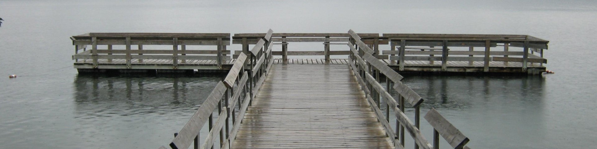
Located adjacent to the Lake Ottawa Campground this deep cold-water lake provides fishermen with a good variety of game fish. There is a boat ramp with ample parking for trailers.
- Accessibility: Access to Lake Ottawa is available by the boat ramp.
- Fishing Mode: Boat or Bank
- Fish Species: Northern Pike, Walleye, Bass (catch and release only), Panfish, and Lake Trout. Note: This lake contains the invasive species rusty crayfish. Please check Michigan’s fishing guide for information on fishing regulations and invasive species.
- Special Designations: Boat Ramp
- Fishing Platform: Yes
- Cleaning Station: No
- Water Temperature: Mixed Cold/warm
- Accessible Platform: Yes
- Fishing Method: Varies
- Water/Flow Level: 90 Feet
- Best Season: May
- Difficulty Level: Easy to Intermediate
- Recreation areas with activity Lake and Pond Fishing:
- Bass Lake
- Brule Lake
- Hagerman Lake
Day Hikes Info
Ge-Che Trail-Several different options are available. Length is approximately 9 miles on a dirt Trail. This trail provides scenery of primarily hardwood forest. This trail is accessible from Lake Ottawa Campground boat landing and also from the campground. Travel west on US 2 from Iron River, turn south on M 73, travel approximately 3/4 mile, turn west on Lake Ottawa Road and travel 4 miles to the campground entrance.
- Fire Information: None
- Status: Open
- Difficulty Level: Easy
- Recreation areas with activity Day Hiking:
- Brule Lake
- Ge-Che Hiking Trail
- Stateline-Miles Post Zero Trail
- Timber Lake Trail Head