
Beaver Meadows Hiking Trail & Day Use Area
The terrain around the lake is gentle, offering a leisurely hike. Opportunities to view wildlife are plentiful.
Beaver Meadows Loop
This 3.0 mile loop is marked with off-white diamonds. South of the lake, the trail passes through a grassy savannah dotted with spruce and pine trees. As the trail nears the headwaters of the lake, look for the small fenced areas that protect blueberry plants from deer browsing. The trail then passes over the lake on a floating boardwalk. North of the lake, the trail climbs to a forest of black cherry and red maple.
Seldom Seen Trail
This trail is 1.2 miles long and is marked with blue diamonds. It passes through a mature forest of black cherry, red maple, beech and red pine. The highlight of the trail is the half-acre blueberry patch. Enjoy the blueberries in late July and August.
Salmon Creek Loop
This loop trail is 1.3 miles long, and is marked with blue diamonds. It is dominated by a peaceful red pine and spruce forest. Several beavers make their home in Salmon Creek. If you are quiet, you may be able to see one.
Penoke Path
This trail is 1.1 miles long and is marked with blue diamonds. As it follows Penoke Run, it passes through a grassy savannah on an old railroad grade. The large old stumps in the savannah are the remnants of a forest that was cut at the turn of the century.
Lakeside Loop
This short 0.5 mile trail is marked with blue diamonds. It takes you closer to the lake to enjoy the scenery, view wildlife, or fish.
Active Alerts
Specific Trail Information
Trail Number
Trail Type
General Information
January - December
When you visit, please remember
- This trail is nonmotorized only.
- No pack or saddle animals.
- No dispersed camping within the former developed campground.

Address: 131 Smokey Lane Marienville, PA 16239
Phone: 814-927-6628
Hours: Tuesday to Saturday: 8:30 am to 12:30 pm and 1:00 pm to 4:00 pm (Closed on federal holidays)
Office Email: sm.fs.anf@usda.gov
Getting There
Directions
From Marienville
- Head northeast on PA-66 N
- Turn left onto N. Forest St.
- Travel north on N. Forest St. for .2 miles
- N. Forest Road becomes Beaver Meadows Road/T358
- Travel on Beaver Meadows Road for 3.7 miles
- The entrance road is located on the right.
Additional Information
Operated By
USDA Forest Service
Recreation Opportunities
Viewing Plants Info
Beaver Meadows Loop - This 3.0 mile loop is marked with off-white diamonds. South of the lake, the trail passes through a grassy savannah dotted with spruce and pine trees. As the trail nears the headwaters of the lake, look for the small fenced areas that protect blueberry plants from deer browsing. The trail then passes over the lake on a floating boardwalk. North of the lake, the trail climbs to a forest of black cherry and red maple.
Many native plants can be found throughout the Allegheny National Forest.
For more information about the types of plants and trees you may see on the Allegheny:
Viewing Wildlife Info
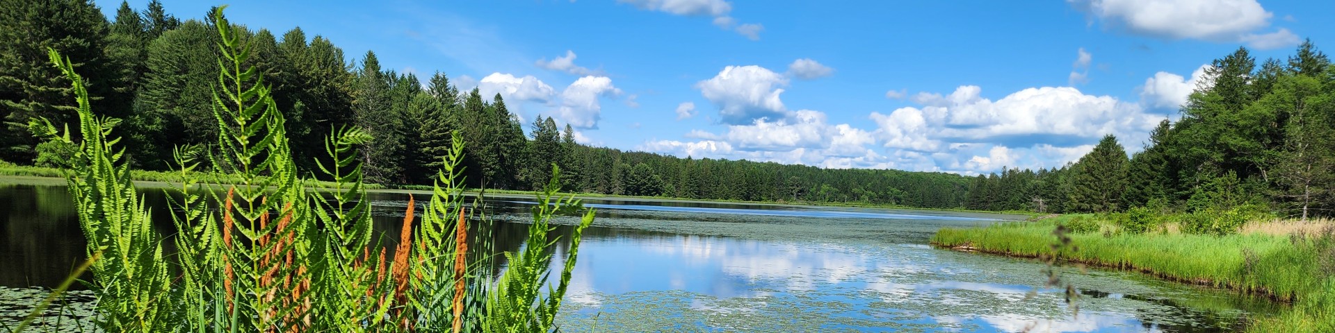
The forest is rich with wildlife, from birds to mammals to fish and other amphibious life. The impoundment at Beaver Meadows Lake serves as a waterfowl refuge. It is the home of many herons, ducks and geese. Beavers also live in and around the lake. A system of interconnecting loop trails serves the area, offering views of a wide variety of natural habitats. A boardwalk crossing at the upper end of Beaver Meadows Lake is a highlight of the trails.
For information on species common to Pennsylvania, and the Allegheny National Forest visit the Pennsylvania Game Commission website for game and nongame species information.
When you see wildlife, please remember:
- never feed wildlife
- don't interfere with mating, predation or other natural behaviors.
- keep a respectful distance
- preserve habitat by following "leave no trace" principles.
- leave young wildlife where you find them.
If you think you've found a sick or injured animal please call the Pennsylvania Game Commission.
Geocaching & Letterboxing Info
Geo-caching is a permissible dispersed recreation activity on most areas of the Allegheny National Forest.
Areas where geo-cacheing is not permitted include:
- Hickory Creek Wilderness,
- Tionesta Scenic and Research Natural Areas,
- Hearts Content Scenic Area and
- all developed recreation sites.
What You Need to Know About GeoCaching:
- No soil disturbance is permitted for any geo-cache placement on the Forest.
- Caches should be covered with leaves or woody debris if the geo-cacher chooses to screen the cache at the site.
- We ask all geo-cachers to remove their cache if the site receives a large number of visits by others as evidenced by a well-worn trail or path.
- We ask that all caches be removed after one year regardless of site activity and moved to a new location or removed from the National Forest.
Day Hikes Info
This system consists of five interconnecting trails, totaling 7.1 miles that wind through the forested hills around Beaver Meadows Lake. This trail begins are Beaver Meadows Recreation Area.
No pack or saddle animals off of designated roadways.