
Sandia RD Crest Highway

Just east of Albuquerque are the most visited mountains in New Mexico. Millions of people journey into the Sandia Mountains each year. More than half these visitors ride the Sandia Peak Tram or drive the Sandia Crest National Scenic Byway to take in spectacular panoramic views of Central New Mexico and to enjoy many other recreational opportunities. The Scenic Byway has several newly remodeled picnic grounds with shelters and group areas for reservation. 

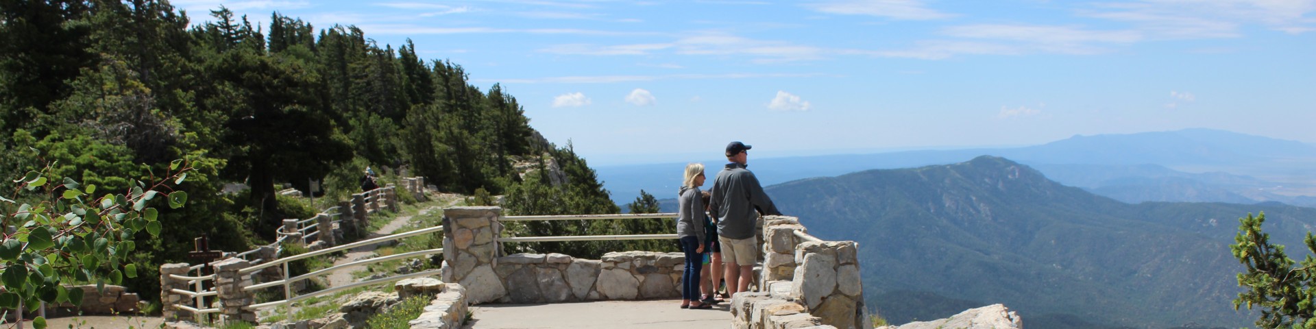
Easy access to Sandia Crest, via Sandia Crest National Scenic Byway, NM 536, or Sandia Peak Tramway, allows a visitor to reach this subalpine mountaintop in minutes. This high ridge offers commanding vistas in all directions, including a birds-eye view of the cliffs and spires of the west face, Albuquerque, the Rio Grande Valley below and a horizon filled with New Mexico’s mountains.

General Information

For a more detailed view of the Sandia Crest Trails click here.

Passes & Permits

Day Use Fees apply for use of trailheads and picnic areas. See posted information for more details. The New Mexico Enchantment Pass is accepted where amenity fees apply. Certain picnic areas have additional reservation opportunities. See Reservation.gov for more details.

Complexes

USDA Forest Service Logo
Site Open

Doc Long Picnic Site is named for Dr. William Henry Long. He was one of three forest pathologists in the USA who conducted pioneering research of tree diseases.

USDA Forest Service Logo
Site Open

Sulphur Canyon Picnic Site has picnic areas dispersed thoroughout the site. They are located along the paved lot and down into the trees.

USDA Forest Service Logo
Site Open

Trailhead includes a large turnaround suitable for horse trailers.

Recreation Sites

Showing: 1 - 10 of 15 results

10k Trailhead and 10K Trail 200

Site Open
Hiking Winter Sports Horse Riding and Camping Biking Picnicking Scenic Drives
10K North and 10K South Trailheads “meet” on Scenic Byway 536, on opposite sides of the highway.--10K Trailhead gives access to 10K Trail 200 going North, and ends at the Del Agua Overlook on…

Balsam Glade Nature Tr - La Madera Canyon Overlook

Site Open
Picnicking Hiking Scenic Drives
Balsam Glade Nature Trail Trailhead is within the Balsam Glade Picnic Site. The nature trail begins at an elevation of 8,620’ to 8,660’ for an elevation gain of 40 feet It is 0.3 miles one way…

Balsam Glade Picnic Site

Site Open
Hiking Picnicking Scenic Drives
The surrounding forest and mountains provide a perfect backdrop for photography, flower walks, bird watching, hiking, relaxing and enjoying nature.The group sheltered area must be reserved on…

Capulin Snow Play Site

Site Open
Scenic Drives Winter Sports
For information on current conditions, contact the Sandia Ranger District.Our first concern is public safety for recreationists using Capulin Snow Play Area. Please use plastic sleds or tubes only…

Capulin Spring Picnic Site

Site Open
Picnicking Hiking Biking Scenic Drives
Capulin Spring is a well-loved recreation spot. It accommodates fifty people. This picnic site is surrounded by heavily wooded land that affords shade to escape the heat of the day. It includes a…

Cienega Equestrian Trailhead

Site Open
Hiking Horse Riding and Camping Scenic Drives
Trailhead includes a large turnaround suitable for horse trailers. The trails associated with this trailhead are: Cienega Equestrian Bypass Trail 266 ; Armijo Trail 222; and Faulty Trail…

Doc Long Picnic Site

Site Open
Hiking Picnicking Scenic Drives
Doc Long Picnic Site is named for Dr. William Henry Long. He was one of three forest pathologists in the USA who conducted pioneering research of tree diseases."Doc" Long, worked in New Mexico from…

Ellis Trailhead, Ellis Trail 202 & FR 488

Site Open
Winter Sports Biking Hiking Horse Riding and Camping
The Ellis trail is 2.7 miles long and begins across the road from the lower parking area of Ellis Traihead. The trail is named for George Ellis who homesteaded Ellis Ranch, in the Sandia Mountains…

Kiwanis Cabin Interpretive Site

Site Open
Winter Sports Outdoor Science and Learning Hiking
The cabin of local limestone was built by the Civilian Conservation Corps (CCC) around 1930. The cabin was planned by a local Kiwanis group.Access the Kiwanis Cabin by walking the Kiwanis Cabin Trail…

Nine Mile Picnic Site

Site Open
Picnicking Hiking Scenic Drives
The entrance is located just off of NM 536 near the nine mile marker. The gate is to the left as you wind up NM 536. It’s surrounded by aspen, spruce and fir trees with a mixture of level and…

Last updated March 25th, 2025