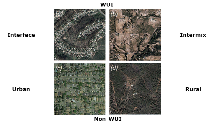
Interface Areas Are Critical to Wildfire Losses: Half of All Buildings Lost in These WUI Areas with Relatively Low Fuels

In California and the entire United States, wildfire management has become more complex, costly and dangerous. Research by a Northern Research Station scientist and her partners found that wildfire losses in California are most common in interface areas, which lack dense wildland fuels. Interface WUI, i.e. settled areas with little wildland vegetation that are near large blocks of wildland vegetation, contained over 50% of all buildings lost to wildfire while making up only 2% of all wildfire perimeters by area (fires from 1985-2013).
Residential development in the wildland-urban interface (WUI) is a major factor in the increased risk and costs of wildfire, and managing that risk falls primarily on local communities in fire-prone areas. Wildfire policy typically focuses on the WUI, where homes meet or intermingle with wildland vegetation, in an attempt to reduce building ignition from either nearby vegetation or from firebrands. A Northern Research Station scientist and her partners examined wildfires across California over the 28-year period between 1985 and 2013 to fully characterize the challenges wildfire poses to homes and buildings in this densely developed and fire-prone state. The study included the 2017 Tubbs fire as a recent case study of a notably destructive and urban wildfire. Researchers found that interface WUI areas (developed areas that have sparse or no wildland vegetation, but are within close proximity of a large patch of wildland) accounted for the majority of building destruction in California wildfires that destroyed at least one building. Interface WUI areas contained 50% of buildings destroyed by wildfire, but composed only 2% of the area burned by these wildfires. Intermix WUI contained 32% of buildings destroyed by wildfire, despite the fact that intermix areas are where homes are intermingled with fuels. This research highlights the need to incorporate non-wildland vegetation, buildings, propane tanks wood piles and vehicles that also fuel fire in the WUI in wildland fire behavior models. In the Tubbs fire, similar to other California wildfires, destruction was primarily in the WUI; however, the Tubbs was unique in having 25% of all destruction in urban areas (in comparison to 4% of destruction falling within urban areas for other California fires). Other recent and highly destructive fires including the 2018 Carr, Camp and Woolsey fires included no urban area within their perimeters, exemplifying the rarity of the Tubbs’ building destruction in urban areas.
Contacts
Publications
External Partners
- H. Anu Kramer and Volker C. Radeloff, University of Wisconsin-Madison
- Patricia M. Alexandre, University of Lisbon

