Research Highlights
Northern Research Station
Forest Disturbance Processes
Disturbances to the forest ecosystem structure can be caused by phenomena such as fire, extreme weather (drought, wind, and ice storms),deer overpopulation, and invasive non-native pest species (fungal diseases, insects, and weedy plants), as well as by anthropogenic factors such as global climate change, logging, development, and arson. These can damage or destroy trees and understory plants and change the species distribution and health of plants and animal populations in the forest. Disturbances can have negative or positive effects on the sustainability of various ecosystems, according to the long-term management goals of the land.
Fewer Pests Found in Wood Packaging Material Following New International Standards

Fewer Pests Found in Wood Packaging Material Following New International Standards
A new international standard for treating wood packaging material, now in use in international trade for items such as pallets and crating, was first adopted by the world community in 2002. This standard, known as International Standards for Phytosanitary Measures No. 15 (ISPM 15), stipulates how wood packaging material should be treated prior to use in packing goods for export. The United States started requiring foreign countries to comply with ISPM 15 when shipping goods to the United States in 2005. A Forest Service research entomologist and his colleagues found as much as a 52 percent drop in the infestation rate of wood packaging material associated with international imports entering the United States following implementation of ISPM 15. This is encouraging news given that many of our invasive bark- and wood-infesting insects, such as the Asian longhorned beetle and the emerald ash borer, likely entered the U.S. as stowaways in untreated wood packaging from foreign ports. The study – “Effectiveness of the International Phytosanitary Standard ISPM No. 15 on Reducing Wood Borer Infestation Rates in Wood Packaging Material Entering the United States” – was published online in the journal PLOS ONE.
- Contact:
- Products & Resources:
- Partners:
- Kerry O. Britton, USDA Forest Service, R&D, Arlington, VA (retired)
- External partners/collaborators: Eckehard G. Brockerhoff, Scion (NZ Forest Research Institute), Christchurch, New Zealand, and Mark Kimberley Scion, Rotorua, New Zealand; James Turner, AgResearch Ltd., Ruakura Research Centre, Hamilton, New Zealand; Joseph F. Cavey, USDA APHIS, Plant Protection and Quarantine, Riverdale, MD, and Lynn J. Garrett, USDA APHIS, Raleigh, NC; Frank Lowenstein, New England Forestry Foundation, Littleton, MA; Amelia Nuding, National Center for Ecological Analysis and Synthesis, University of California, Santa Barbara; Lars J. Olson, University of Maryland, Agricultural and Resource Economics, College Park; and Kathryn N. Vasilaky, Earth Institute and International Research Institute for Climate and Society, Columbia University, New York, NY
- Year: 2014
Ash at the Confluence of Two Threats: Emerald Ash Borer and Climate Change

Ash at the Confluence of Two Threats: Emerald Ash Borer and Climate Change
Black ash, a dominant tree species of forested wetlands in Minnesota, Wisconsin and Michigan, provides multiple ecosystem services. It is also a valuable resource for Native American crafters, especially basket-makers. The tree’s existence is threated by the emerald ash borer (EAB), which is killing virtually all ash throughout the Midwest. EAB is now threatening the vast black ash swamps of the Northwoods, and although efforts to slow its spread have been somewhat successful, EAB has not yet been stopped. In addition, climate change impacts models indicate that habitats for black ash will diminish in future decades. Forest Service researchers identified tree species that may be able to replace black ash, including species that could be planted now to ensure that forests remain after EAB damage and after substantial changes in climate have occurred. The models showed that many species currently dominating the Northwoods – quaking aspen, balsam fir, balsam poplar and paper birch – may lose substantial habitat due to warming and varied hydrological conditions, and thus are less suitable as long-term replacement species. Species including American elm, American basswood, red maple, bur oak, and boxelder may be able to colonize areas vacated by the loss of black ash.
- Contact:
- Products & Resources:
- Minnesota forest ecosystem vulnerability assessment and synthesis: a report from the Northwoods Climate Change Response Framework project
- Tree-species range shifts in a changing climate: detecting, modeling, assisting
- Potential replacements for northwoods black ash in a changing climate: the confluence of two challenges
- 0
- Partners:
- Year: 2014
Municipal Cooperation in Managing Emerald Ash Borer Increases Urban Forest Benefits
A regional plan for managing an EAB infestation of an urban forest greatly improves the percentage of healthy ash trees and the value of their services

Municipal Cooperation in Managing Emerald Ash Borer Increases Urban Forest Benefits
A regional plan for managing an EAB infestation of an urban forest greatly improves the percentage of healthy ash trees and the value of their services
A new analysis of emerald ash borer (EAB) spread in urban forests shows that a regional management and funding strategy would control the infestation more effectively than city-by-city responses or no response. A Forest Service scientist and partners analyzed EAB management plans and budgets for Minneapolis, St. Paul, and 15 Minnesota cities with recent EAB infestations. They projected tree mortality and the costs of tree removals, replacement trees, and pesticide treatments and calculated how trees increase property values. The first scenario assumed none of the cities committed funds and the EAB population spread unmitigated. The second scenario assumed the 17 cities managed the infestation independently with their own city budgets. The third scenario assumed the 17 cities pooled resources to manage the infestation on a regional scale. In the first scenario, removal and replacement costs far exceeded the amount the remaining trees improved property values. The second scenario returned a similar result. When the cities pooled resources in the third scenario, increased property value benefits of the surviving trees far exceeded the costs of treatments, removals, and replacement trees. Comparing the second and third strategies show definitively that regional cooperation and implementation of EAB management greatly improves urban forest benefits.
- Contact:
- Products & Resources:
- Partners:
- Kent Kovacs, University of Arkansas, Fayetteville; Rodrigo Mercader, Washburn University, Topeka, KS; Deborah McCullough, Michigan State University
- Year: 2014
Identifying Policy Tools That Encourage Community-Level Defensible Space in Six U.S. Communities

Identifying Policy Tools That Encourage Community-Level Defensible Space in Six U.S. Communities
Numerous factors contribute to whether or not an individual will take action to reduce his or her wildfire risk. When an individual opts to not implement risk mitigation measures, community leaders can use a variety of policy tools to encourage that person to adopt an action or change behavior. These tools included passing rules or regulations, building capacity to act, providing incentives, and establishing community norms. A Forest Service scientist and partners reviewed approaches used by six communities in Idaho, Oregon, and Utah that have been effective at encouraging homeowners to adopt and maintain mitigation activities. Each community’s approach was different. Each was tailored to meet specific community needs, and ranged from collective efforts organized locally to efforts developed externally to provide incentives or potential punishments for not adopting treatments. The most consistent policy tool across communities was capacity building, primarily raising awareness of the fire hazard and potential mitigation behaviors and leveraging external resources, generally obtaining grant funding to assist with vegetation reduction efforts. Another commonality was the involvement of a central group or individual that provided leadership by initiating and championing the mitigation effort and serving as a link to external resources.
- Contact:
- Products & Resources:
- Partners:
- Eric Toman and Melanie Stidham, Ohio State University; Bruce Shindler, Oregon State University
- Year: 2014
Restoration of Degraded Northern Forest Stands
Forest Service research informs returning stands with a history of exploitative cutting to sustainable forest management

Restoration of Degraded Northern Forest Stands
Forest Service research informs returning stands with a history of exploitative cutting to sustainable forest management
Many forests throughout the United States have a long history of commercial timber extraction. Although forestry research provides a basis for sustainable management, a focus on short-term financial gain often leads to exploitative harvesting in which valuable trees are removed without attention to residual stand condition, often leading to degraded forests with poor composition and vigor. As a consequence, landowners are faced with the difficult task of trying to restore desired attributes to stands with limited production potential. Forest Service scientists are working with researchers and managers in the northeastern U.S. and adjacent parts of Canada to study management alternatives for rehabilitation of degraded stands. Working with university and government partners in the U.S. and Canada, they developed a coordinated program of research and application that informs the restoration of functionality and productivity to forests throughout the region. In addition to workshops, field tours, and webinars in Maine, New York, and Quebec, the group’s work recently served as the basis for a special section on Restoration Silviculture in the Journal of Forestry.
- Contact:
- Products & Resources:
- Partners:
- Ralph Nyland, State University of New York: Jeremy Wilson, Harris Center, NH (formerly University of Maine); Mohammad Bataineh, University of Arkansas (formerly University of Maine); Steve Bedard, Francois Guillemette, Patricia Raymond, Stephane Tremblay, and Catherine Larouche, Quebec Ministry of Natural Resources; Jean-Martin Lussier, Canadian Forest Service; Roger Greene at Mason, Bruce, & Girard, Inc., ME.
- Year: 2014
Urban Natural Resource Stewardship
More than 80% of the U.S. population lives in urban and suburban areas. The urban forests---street and park trees as well as landscape plantings on private lands---provide important ecosystem services to urban residents and workers. A healthy urban forest can help reduce air pollution and urban core temperatures and thus make cities more livable. Mitigation of past declines of urban forests and open space; maintenance of the health of street trees and open spaces; revitalization of neighborhoods and righting of past environmental injustices are important issues for urban forest managers.
Air Pollution as a Psychosocial Stressor

Air Pollution as a Psychosocial Stressor
Exposure to air pollution and its sources is increasingly viewed as a psychosocial stress, but its nature is not well understood. A Forest Service scientist, with partners from Drexel University, University of Pennsylvania and organizations in South Philadelphia, explored the role of the concept of “place” on risk perception and community stress within data collected from eight focus groups in Philadelphia, Penn. Discussions focused on air pollution, a nearby oil refinery, health, and a proposal for air monitoring. The framework of place-based elements of risk perception includes place identity, stigma, and social control. The findings indicate that air pollution contributes to physical and psychosocial conditions that act as community-level social stressors. Findings also suggest that programs that seek to change behaviors and gather or spread information on issues such as pollution and other environmental concerns will be challenged unless they directly address: (1) the public's identification with a place or industry; (2) immediate environmental stressors such as abandonment, waste, and odors; and (3) public perceptions of lack of social control and fear of displacement.
- Contact:
- Products & Resources:
- Partners:
- Year: 2014
Trees Improve Human Health and Save Lives
Computer modeling shows that trees’ removal of air pollution reduces human mortality by about 850 people per year nationally
 of all pollutants (NO2, O3, PM2.5, SO2) by trees per county in 2010. Map by USDA Forest Service")
Trees Improve Human Health and Save Lives
Computer modeling shows that trees’ removal of air pollution reduces human mortality by about 850 people per year nationally
Air pollution is a serious health concern. Trees remove air pollution by intercepting particulate matter on plant surfaces and absorbing gaseous pollutants through the leaf stomata. Forest Service and Davey Institute scientists developed and ran computer simulations with local environmental data showing that trees and forests in the conterminous United States removed 17.4 million metric tons of air pollution in 2010 with human health effects valued at 6.8 billion dollars. This pollution removal equated to an average air-quality improvement of less than 1 percent. Most of the pollution removal occurred in rural areas, while most of the health impacts and values were within urban areas. Health impacts included the avoidance of more than 850 incidences of human mortality and 670,000 incidences of acute respiratory symptoms.
- Contact:
- Products & Resources:
- Partners:
- Year: 2014
Jamaica Bay Social Assessment
A rapid social assessment of urban parkland: Analyzing park use and meaning to inform adaptive management and resiliency planning in New York City’s Jamaica Bay region

Jamaica Bay Social Assessment
A rapid social assessment of urban parkland: Analyzing park use and meaning to inform adaptive management and resiliency planning in New York City’s Jamaica Bay region
New York City’s socially and ecologically diverse Jamaica Bay region, population approximately 900,000, became a focus of resiliency planning and adaptive management efforts following Hurricane Sandy in October 2012. Working in partnership with the Natural Areas Conservancy (NAC) and NYC Department of Parks and Recreation (NYC Parks), Forest Service scientists developed a rapid assessment methodology to understand the public use, social meaning, and stewardship potential of parks in the region. This study assessed the 2,140 acres of public parkland adjacent to the Bay that are managed by NYC Parks. The assessment is spatially explicit, scalable, and replicable so that natural resource managers can use it in adaptive management. The focus on speed and replicability enables managers to examine change in socio-cultural ecosystem services over time in the wake of both acute, large-scale disasters and other chronic forms of disturbance. This study will lead to park profiles, white papers, presentations, and datasets for managers. The pilot has been scaled up to a citywide study exploring the use and meaning of ‘natural areas’ in parks. In the future, social data will be combined with citywide ecological assessment data to inform the conservation and management priorities of the NAC and NYC Parks.
- Contact:
- Products & Resources:
- Partners:
- Bram Gunther, NYC Department of Parks and Recreation; Sarah Charlop-Powers, Helen Forgione, Clara Pregitzer, Natural Areas Conservancy
- Year: 2014
Cold Winter Temperatures Set Emerald Ash Borer Back in Minnesota
, killed during the winter of 2013-14. Photo by Rob Venette, USDA Forest Service")
Cold Winter Temperatures Set Emerald Ash Borer Back in Minnesota
Emerald ash borer has devastated urban and natural forests in most states where it occurs, causing 100 percent mortality of susceptible ash species. Although emerald ash borer has been in Minnesota since 2009, little mortality has been observed and spread has been slower than in other states. Forest Service researchers have been evaluating the role cold temperatures might play in regulating populations of this insect. In general, the insect survives exposure to temperatures from 0 to -20°F by producing cryoprotectants, so in many places, cold temperatures may not have an impact on this insect. However, as within-tree temperatures fall below -20°F, mortality rates begin to increase. With the Polar Vortex in January 2014, air temperature in the Twin Cities fell to -23°F, a temperature that could cause up to 80 percent mortality. Samples taken from cut logs and standing trees that had been outdoors during the winter showed that 60 to 70 percent of larvae had been killed in most locations. Winter mortality of emerald ash borer is unlikely to eliminate this insect but may give natural resource managers more time to respond to this insect in areas where extremely cold winter temperatures (less than -30°F) are common.
- Contact:
- Products & Resources:
- Partners:
- Year: 2014
Sustaining Forests
The Northeastern and Midwestern forests are the defining elements of much of the natural environment in their region. This region is the most heavily forested region of the United States, and 76 percent of the forested lands are privately owned, mostly by non-industrial, family landowners. Sustaining this mix of privately owned and public forests involves understanding their ecology (at scales ranging from individual organisms to broad landscapes); their relationships to people and communities; and developing appropriate management strategies in the face of changing environmental conditions (climate) and of changing social conditions (economics and demographics).
Scientists Collaborate to Deliver Best Science on Climate Change and Forests
More than 130 scientists and natural resource managers collaborated to provide high-quality information on the effects of climate change on forest ecosystems

Scientists Collaborate to Deliver Best Science on Climate Change and Forests
More than 130 scientists and natural resource managers collaborated to provide high-quality information on the effects of climate change on forest ecosystems
USDA Forest Service scientists are working with a diverse network of partners to develop and deliver key information about climate change impacts to forest ecosystems. Forest managers working on public, private, and tribal lands are most interested in specific, local information, that helps them understand the effects of climate change on the places where they work. Until recently, this information was not easily accessible to managers because it was dispersed across many complex scientific papers and studies. Forest Service scientists and their partners hosted a series of workshops that interpreted the latest information on climate change impacts and assessed the vulnerability of different ecosystems to climate change. The result is a series of vulnerability assessment reports summarizing current scientific knowledge about climate change in different forested regions of the Midwest and Northeast. Each assessment provides information on past and projected climate change, as well as expected changes in forests based on modeling studies and other research. Most important, information is provided for individual forest communities, increasing relevance and usefulness for forest managers. This assessment series will also form a core product for the newly created USDA Regional Climate Hubs, which are designed to aid forest managers in making climate-informed decisions.
- Contact:
- Products & Resources:
- Central Hardwoods ecosystem vulnerability assessment and synthesis: a report from the Central Hardwoods Climate Change Response Framework project
- Michigan forest ecosystem vulnerability assessment and synthesis: a report from the Northwoods Climate Change Response Framework project
- Minnesota forest ecosystem vulnerability assessment and synthesis: a report from the Northwoods Climate Change Response Framework project
- 0
- Partners:
- National Forest System, Eastern Region
- Northeastern Area, State & Private Forestry
- Central Hardwoods Joint Venture; Gulf Coast Plains and Ozarks Landscape Conservation Cooperative; Upper Midwest & Great Lakes Landscape Conservation Cooperative; The Forestland Group; The Nature Conservancy; Trust for Public Land; Fond du Lac Tribe, Cloquet, Minn.; Keweenaw Bay Indian Community, Baraga, Mich.; Sault Ste. Marie Tribe, Sault Ste. Marie, Michigan
- Illinois Department of Natural Resources; Maryland Department of Natural Resources, Michigan Department of Natural Resources; Natural Features Inventory; Michigan Technological University; Minnesota Department of Natural Resources; Forest Resources Council; University of Minnesota; UPM-Blandin Forestry, Grand Rapids; Rajala Companies, Deer River; Missouri Department of Conservation; University of Missouri
- Year: 2014
Building Forests That are Adapted to Drought
A nation-wide operational-scale management experiment shows that silvicultural treatments can reduce the vulnerability of forests to drought

Building Forests That are Adapted to Drought
A nation-wide operational-scale management experiment shows that silvicultural treatments can reduce the vulnerability of forests to drought
In much of the United States, summer droughts are expected to become more frequent and intense, and longer in duration due to climate change. Soil moisture deficits will cause declines in tree vigor and loss of forest growth, resulting in degraded wildlife habitat, reduced carbon uptake, and loss of forest productivity. Researchers with the Forest Service, the USGS, and the Universities of Minnesota and Maine have implemented an experiment on USFS experimental forests to examine forest growth response to past droughts as influenced by different levels of tree stocking (basal area) and regeneration methods. The study capitalizes on Forest Service R&D’s unique research infrastructure on Experimental Forests, which maintains long-term silvicultural experiments with different stand structures that are 50 years old or older, across several past drought events in a wide range of forest types. Results show that stocking levels can minimize growth losses during and after drought in a range of forests, including red pine, ponderosa pine, and northern hardwoods. This project is unique in scope and scale and is helping managers understand how to adapt forests to a changing climate so the effects of drought are minimized and ecosystem goods and services continue.
- Contact:
- Products & Resources:
- Partners:
- Year: 2014
Private Forest Landowner Attitudes Towards Forest Carbon Management and Carbon Credit Trading
Opportunities to meet landowner goals for their forestland

Private Forest Landowner Attitudes Towards Forest Carbon Management and Carbon Credit Trading
Opportunities to meet landowner goals for their forestland
If forest carbon management activities are to have a meaningful role in national carbon sequestration efforts, private forest landowners will likely need to play a significant role. Forest Service scientists and university partners conducted focus groups with private forest landowners in Minnesota, Michigan and Wisconsin to gain greater understanding into landowner attitudes toward carbon management and carbon market participation. Results suggest that landowners prefer higher carbon credit payments and shorter contract lengths than those currently offered in carbon market platforms. Landowners with the greatest interest in participating in carbon markets see carbon management as way to make changes that would improve the quality of their forestland. Conversely, landowners who are satisfied with the quality of their forestland or the way in which it is currently managed are less interested in participating in forest carbon markets. Overall, scientists found greater interest in the personal benefits that landowners might attain from carbon management, rather than the public good of reducing carbon levels. Research suggests that carbon market participation may not be the most effective means of encouraging forest landowners to sequester carbon, and that opportunities may exist to promote carbon management through existing forest landowner assistance programs.
- Contact:
- Products & Resources:
- Partners:
- Year: 2014
Uneven-Aged Management: Is It Sustainable?

Uneven-Aged Management: Is It Sustainable?
In North America, interest in uneven-aged management grew in the second-half of the twentieth century after most of the old-growth forests had been harvested. In the uneven-aged management style, trees from all size classes are periodically removed to mimic the patterns of older, unmanaged forests. To investigate this management style, Forest Service scientists set up long-term experiments on the Fernow Experimental Forest in West Virginia. In the ensuing half-century, almost all of foresters’ original beliefs about forest management were partially or wholly invalidated. Findings from the Fernow EF illustrate that the original value-laden assumptions were faulty and there is a need to test commonly held beliefs. Long-term forest research data also have many useful benefits; what were originally experiments in silviculture for sustained yield of forest products now yields information about carbon storage, forest restoration, wildlife habitat, rare species, water quality, and forest response to climate change.
- Contact:
- Products & Resources:
- Partners:
- Year: 2014
Providing Clean Air and Water
Northeastern and Midwestern forests are vital for providing abundant clean water and air for the regions' many rural and urban inhabitants. For example, water that has passed through forests is cleaner than water than that has drained from roads or disturbed lands. By taking up carbon dioxide for use in photosynthesis, trees help reduce greenhouse gases and improve the local and global environment. Forests also receive harmful atmospheric pollutants such as acid precipitation and mercury, which alter the soil and harm tree health and alter lake ecosystems.
New Tool for Predicting Smoke Dispersion During Low-Intensity Fires
Anticipating effects of prescribed fires on air quality enhances safety

New Tool for Predicting Smoke Dispersion During Low-Intensity Fires
Anticipating effects of prescribed fires on air quality enhances safety
The effects low-intensity prescribed fires used for fuels management have on air quality are a particular concern for fire and air-quality management communities throughout the United States. Smoke from prescribed fires, which are often used in wildland-urban-interface (WUI) areas and in areas where forest vegetation has a significant impact on the local meteorology, can linger for relatively long periods of time and adversely affect human health and safety. The planning and tactical management of low-intensity prescribed fires can be enhanced with models and decision-support tools that are able to predict the ambient and fire-induced meteorological environment at forested burn sites and the effect of that environment on local smoke transport. Forest Service researchers collaborated with colleagues at Michigan State University to develop and evaluate a coupled meteorological/particle-dispersion model suitable for predicting local meteorological and air-quality impacts of low-intensity wildland fires in forested environments. The modeling system was tested using meteorological and air-quality data collected during prescribed fires conducted by the New Jersey Forest Fire Service in the New Jersey Pine Barrens and is now being evaluated as a potential real-time operational tool for fire and smoke management.
- Contact:
- Products & Resources:
- Partners:
- Year: 2014
Estimating Greenhouse Gas Fluxes in Managed Forests

Estimating Greenhouse Gas Fluxes in Managed Forests
Farms and forests are sources and sinks of greenhouse gases (GHGs), and land management practices can reduce GHG emissions and increase carbon storage. The 2008 Farm Bill directed USDA to develop technical guidelines to help forest, farm, and ranch managers quantify the changes in their GHG footprint that could result from a change in management practices. Forest Service scientists played key roles in developing the methods recommended for measuring changes in GHG emissions and carbon storage in managed forests. The team’s goal was to produce transparent and scientifically sound guidelines, and these methods were reviewed by federal GHG specialists, academic experts, and the public. The report, “Quantifying Greenhouse Gas Fluxes in Agriculture and Forestry: Methods for Entity-Scale Inventory,” was published in July 2014 and will serve as the blueprint for the development of user-friendly web-based GHG inventory tools. These tools will enable landowners to estimate changes in GHG emissions and carbon stocks that result from changes in forest management practices, allowing them to participate in emerging markets for carbon and other ecosystem services.
- Contact:
- Products & Resources:
- Partners:
- Pacific Southwest Region
- Fire and Aviation Management
- USDA Office of the Chief Economist; Appalachian State University; Virginia Polytechnic University; Michigan State University
- Year: 2014
Linking Land Use to Water Quality
 and turbidity (NTU) for watersheds with observed values (gauged) and based on landscape variables only (unguaged) for Lake Michigan. Gray areas are the portions of the basin not modeled. Map by USDA Forest Service")
Linking Land Use to Water Quality
The Great Lakes Restoration Initiative is investing hundreds of millions of dollars to improve the quality of the Great Lakes. One of the projects promotes nearshore health and prevention of harmful algal blooms. But might these problems be minimized through wise management and stewardship of the lakes’ watersheds? Forest Service scientists demonstrated that sediment and phosphorus delivery to the lakes is influenced by land use and land cover and their change over time. For example, phosphorus levels in Lake Superior increased with the proportion of persisting forest, forest disturbed during 2000-2009, and agricultural land; sediments (turbidity) increased with the proportion of persisting forest, forest disturbed during 2000–2009, agricultural land, and urban land. In both cases, agriculture and forest disturbance were the most important predictors of water quality impairment. However, water quality is not measured everywhere. Forest Service scientists developed models to predict likely water quality problems in streams that are not monitored. This will allow land managers to prioritize restoration investments and management activities across the entire basin, monitored and not monitored. The supporting inventory and forest canopy cover change data were published for the public’s use in their own assessments.
- Contact:
- Products & Resources:
- Partners:
- Year: 2014
Contrasting Effects of Invasive Insects and Fire on Forest Carbon Dynamics
Oak- and pine-dominated forests in the New Jersey Pinelands can recover more rapidly from prescribed fires than from invasive insect damage

Contrasting Effects of Invasive Insects and Fire on Forest Carbon Dynamics
Oak- and pine-dominated forests in the New Jersey Pinelands can recover more rapidly from prescribed fires than from invasive insect damage
Forest Service scientists quantified changes in forest structure and measured water use and net carbon dioxide (CO2) exchange from towers in forest stands that were burned in prescribed fires or defoliated by invasive insects. Prescribed burns resulted in little change to nitrogen in foliage during the following growing season, while insect defoliation and subsequent tree mortality reduced canopy nitrogen pools. Ecosystem Water Use Efficiency (WUEe) was reduced to 60 percent and 46 percent of pre-disturbance values in oak-dominated and mixed stands during defoliation; prescribed fire had little effect. Over a decade, carbon sequestration by an intensively studied defoliated stand totaled about 5.4 tons C per hectare, while a burned stand sequestered 10.6 ton carbon per hectare. These results indicate that forest carbon dynamics, and especially rates of net CO2 exchange, are more sensitive to disturbance than hydrologic fluxes, and disturbances that result in large nitrogen transfers within stands may have long-term effects on rates of carbon sequestration. This work improves scientists’ ability to predict interactions between carbon and water cycles under climate change scenarios that result in a greater probability of insect invasions, wildfire, or other disturbances.
- Contact:
- Products & Resources:
- Partners:
- Year: 2014
Best Management Practice Monitoring Training Delivered to National Forests

Best Management Practice Monitoring Training Delivered to National Forests
Best management practices (BMPs) include planning and field techniques to control pollutants attributable to diverse types of land uses. For the Forest Service, the largest land management agency in the United States, BMPs are fundamental to protecting water quality and aquatic health. The National BMP Monitoring Protocols were developed to monitor BMP use and effectiveness for all of the major types of land-disturbing activities and features managed by the Forest Service. As the result of several directives, including the new planning rule, all agency units are now required to conduct monitoring annually. National Forest System field personnel identified training as a priority need to implement BMP monitoring. Forest Service scientists who played a lead role in the development of the monitoring protocols, are also leading the training efforts. A Forest Service scientist worked with a soil scientist from the Kaibab National Forest to conduct 2-day training sessions during summer 2014 at more than a dozen locations, from Georgia to California and from Alaska to Louisiana. Each training session was followed by field site monitoring at locations chosen by the host unit. Overall, more than 150 Forest Service employees participated in the training, and some of those individuals will help train others in future sessions.
- Contact:
- Products & Resources:
- Partners:
- Year: 2014
Natural Resources Inventory, Monitoring, and Assessment
Ensuring the health and sustainability of the nation's forests requires scientifically credible and timely information about the extent, location, health, and ownership of these forests and the possible effects of global climate change. Forest managers and policy makers need detailed data to assess sustainability, to make important business decisions, to evaluate wildlife habitat, and for many other things. The Northern Research Station's Forest Inventory and Analysis (FIA) team is an important part of the national FIA network, which provides information on northeastern, Midwestern, and Great Plains forests.
If a Tree Falls in a Forest, How Long Does It Lie There?

If a Tree Falls in a Forest, How Long Does It Lie There?
Downed and dead woody material (DWM) is created when trees fall or shed branches, and DWM is a substantial pool of carbon. The removal of DWM during harvests has raised questions regarding how long it would normally reside in forests. If DWM is determined to be a long-term store of carbon, then its conservation during harvests might be considered “carbon friendly.” Forest Service scientists developed a technique for matching measured DWM pieces over short periods of time. Instead of waiting for DWM to decay (possibly a 100-year wait), a model was created to predict the probability of DWM moving from one stage of decay to the next. The decay model was applied to a DWM inventory across the eastern United States to estimate the residence time of DWM. For hardwood species, especially small DWM in warm/humid climates, over half of the DWM biomass is lost to the atmosphere or other carbon pools within 10 years. For coniferous DWM in cold/dry climates, it may take over 100 years for carbon to be emitted or transferred to other pools. If a tree falls in a forest, how long does it lie there? In eastern U.S. forests, the answer is between 30-100 years.
- Contact:
- Products & Resources:
- Residence times and decay rates of downed woody debris biomass/carbon in eastern US forests
- Estimates of downed woody debris decay class transitions for forests across the eastern United States
- Tracking downed dead wood in forests over time: Development of a piece matching algorithm for line intercept sampling
- Partners:
- Year: 2014
Forest Ownership Map of the Conterminous United States

Forest Ownership Map of the Conterminous United States
Nearly two-thirds of the forests of the conterminous U.S. are privately owned, not publicly owned, as many assume. To help clear up this understanding, Forest Service scientists have created a map and a spatial data product to help illustrate the distribution of forest ownership across the nation. The data product contains raster data depicting the spatial distribution of forest ownership types in the conterminous United States circa 2009. The data are a modeled representation of forest land by ownership type, and include three types of public ownership: federal, state, and local, as well as three types of private: family (includes individuals and families), corporate, and other private (includes conservation and natural resource organizations, unincorporated partnerships and associations, and Native American tribal lands).
- Contact:
- Products & Resources:
- Partners:
- Year: 2014
Nationwide Datasets of Tree Species Distributions
Traveling the full path from research creation to educational outreach

Nationwide Datasets of Tree Species Distributions
Traveling the full path from research creation to educational outreach
Forest composition, as characterized by tree distribution and abundance, provides essential information for understanding and studying forest processes and services. Datasets depicting the distribution and basal area of 323 individual tree species have been developed by Forest Service scientists for the lower 48 United States by integrating the Forest Service’s extensive forest inventory database with vegetation phenology from satellite imagery and relevant environmental parameters, such as topography and climate. Each of these datasets was examined for accuracy using a suite of assessment procedures developed to characterize errors by their location, type, and magnitude across a range of scales. Assessment revealed that these 250-m resolution datasets can provide information on individual tree species that are at a sufficient level of spatial detail and accuracy to be useful for many purposes, particularly for common species. The documented datasets and assessment results have been archived and are available on the web for download. Finally, state-level posters are available that are attractive and technically informative for both adults and students. These posters provide visual maps and numeric information for comparing and contrasting multiple tree species within each state, and inspire awareness of and increased access to the geospatial datasets and the science behind them.
- Contact:
- Products & Resources:
- Partners:
- Year: 2014
Bird Monitoring in the Western Great Lakes National Forests Shows Stabilized Breeding Bird Populations
 has had significantly increasing numbers on western three Great Lakes national forests since 1995. Photo by Jon Swanson")
Bird Monitoring in the Western Great Lakes National Forests Shows Stabilized Breeding Bird Populations
Systematic annual and habitat-specific surveys of breeding birds were conducted by Forest Service scientists and their university partners in the Chequamegon-Nicolet, Chippewa, and Superior National Forests over the last two decades. They studied population trends from 1995 to 2011 for 97 species of forest birds. Their results suggest that, overall, breeding bird populations of many species were stable or increasing over the past 17 years, which is a positive reflection of forest condition within these national forests. Only a few species showed a declining trend over this recent time period. Results illustrate the relative importance of habitat, climate, geography, and human development as drivers of bird species distributions in the study area. Their data on trends from the past two decades suggest that populations of forest breeding bird populations within these four national forests of the region have stabilized – a result with important implications about the regional health of forest communities in this hotspot of avian diversity.
- Contact:
- Products & Resources:
- Partners:
- Year: 2014
Environmental Literacy
The Northern Research Station is committed to advancing environmental literacy in learners of all ages. Station scientists have worked with students and educators in the classroom, support development of science-based investigations and lesson plans, and participate through science fairs and career days across the Northeast and Midwest. With researchers in Ohio, middle school students are even hatching and rearing parasitic wasps that may help control emerald ash borer in the future. We've co-published The Investigator, a new science education journal for upper elementary school students, and contributed to the development of i-Tree Learning Lab, a lesson plan for high school students to learn the benefits of urban forests.
Forest Management Guidelines for Improving and Sustaining Missouri's Forest Resources
Ensuring the quality of life and well-being of Missouri residents and visitors through productive, healthy, and resilient forests

Forest Management Guidelines for Improving and Sustaining Missouri's Forest Resources
Ensuring the quality of life and well-being of Missouri residents and visitors through productive, healthy, and resilient forests
With the publication of “Missouri Forest Management Guidelines,” for the first time Missouri landowners have comprehensive guidelines and best management practices to improve and sustain high-quality forests. Northern Research Station scientists were key contributors to the production of these guidelines, which were published by the Missouri Department of Conservation. Over the past 18 months, these scientists drew upon their more than 80 years of forest research expertise to contribute to the guidelines. Most forest lands in Missouri (84 percent) are privately owned, and currently less than 10 percent of Missouri’s 15.5 million acres of forestlands are managed according to any type of forest plan. “Missouri Forest Management Guidelines” provides (1) an awareness of forest resources and their importance to the quality of life in Missouri, (2) an understanding of forest sustainability and the foundation of good forest management through planning and silviculture, and (3) a synthesis of current science that is embodied in standards, guidelines and best management practices. The ultimate value of forest research is fully realized when it is adopted by owners and managers of forestlands.
- Contact:
- Products & Resources:
- Partners:
- Mark Twain National Forest
- National Wild Turkey Federation; Forest and Woodland Association; Natural Resources and Conservation Service; U.S. Fish and Wildlife Service; The Nature Conservancy. Missouri Department of Conservation; Missouri Department of Natural Resources; Missouri Consulting Foresters Association; Tree Farm System; University of Missouri; Mark Twain Forest Watchers; Missouri Forest Products Association
- Year: 2014
PBS Kids Partnership Helps Kids Explore Nature "One Mission at a Time"

PBS Kids Partnership Helps Kids Explore Nature "One Mission at a Time"
Urban forests and the Forest Service are featured in two live-action videos on PBS Kids’ newest multi-media environmental science learning program, “PLUM LANDING.” The program brings a space traveler, PLUM, from the planet Blorb to investigate the incredible ecosystems on Earth. Children, families, and educators can learn about nature around the world and in their backyards through animated and live-action videos, online games and outdoor explorations, and a full curriculum linked to the Next Generation Science Standards for nonformal educators. An associated app, “PLUM’s Photo Hunt,” sends kids on missions to find weird things in nature, signs of animal life, cool trees or flowers, and more. In its first 3 months, the PLUM LANDING website received more than 11 million page views through more than 2 million separate website visits; and more than 110,000 photos and drawings were submitted online. Future outreach efforts will include community service learning opportunities in partner cities across the country to engage families where they live.
- Contact:
- Products & Resources:
- Partners:
- Year: 2014
Woodpeckers Capitalize on an Invasive Forest Pest

Woodpeckers Capitalize on an Invasive Forest Pest
To understand how woodpeckers respond to emerald ash borer (EAB) and whether there is potential for woodpeckers to control EAB, Forest Service scientists and partners conducted surveys and dissected infested ash trees at Dempsey Middle School’s forest in Delaware, OH. They observed external signs of woodpecker feeding on ash and non-ash species. The seventh- and eighth-grade advanced science classes worked with scientists to mark holes and dissect infested ash trees to determine how many EAB larvae lived in the ash trees and how many were eaten by woodpeckers. Scientists found that woodpeckers specifically targeted ash trees, creating 14 times more feeding holes in ash trees than in other tree species. When feeding on ash trees, woodpeckers specifically targeted trees more highly infested by EAB. Woodpeckers consume a significant proportion of EAB larvae: of the 7,098 EAB larvae that were evident in these dissected trees, 2,624 (37 percent) had been eaten by woodpeckers. In some highly infested trees, up to 85 percent of the EAB larvae were consumed.
- Contact:
- Products & Resources:
- Partners:
- Deb Bogard, Dempsey Middle School, Delaware, OH; Joel S. Brown, Charles E. Flower, and Miquel A. Gonzalez-Meler, University of Illinois at Chicago
- Year: 2014
Woodland Ecology Research Mentorship in New York City
New York City high school students learned to assess urban forest plots and evaluate tree health through a Forest Service mentorship program

Woodland Ecology Research Mentorship in New York City
New York City high school students learned to assess urban forest plots and evaluate tree health through a Forest Service mentorship program
Wave Hill, a public garden and cultural center in the Bronx, New York, selects academically-achieving teens from low-income households to participate in a 15-month Woodland Ecology Research Mentorship (WERM) program. Funded by the Pinkerton Foundation, this innovative internship provides a stipend to students as they take college-level environmental science coursework, learn urban forestry survey techniques, and develop an individual research project with the help of a local scientist mentor. This past year, a Forest Service scientist became a mentor, teaching workshops about urban tree health, park-user rapid assessment techniques, and statistical analysis. The scientist also helped lead a field trip to a nearby rural forest to discuss long-term ecosystem change and compare urban and rural forest dynamics.
- Contact:
- Products & Resources:
- Partners:
- Year: 2014
2014 Research Highlights
It is the privilege of the Northern Research Station, and all of Forest Service Research and Development, to produce science that is improving people’s lives and the health and resilience of the natural resources on which they depend. This year, we made incredible gains in redeeming our mission.
The Northern Research Station led the way in reaching out to urban America so we could better “…care for the land and serve people, where they live.” Our urban field stations in Evanston, Illinois; New York City; Philadelphia and Baltimore are illustrating how the Forest Service has a vital role in land stewardship across a complex gradient of forests, from deep wilderness to urban parks. With over 83 percent of Americans living in urban areas, our contributions to science, management, and technology transfer enable us to meet the contemporary conservation challenges that people strive to achieve.
Our scientists and support staff continued addressing the national emphasis on forest disturbances. From establishing the USDA Climate Change Hubs in Durham, New Hampshire and Houghton, Michigan to combating the emerald ash borer to striving to save bats from the White-nose Syndrome, our scientists are finding answers to pressing questions of today and the decades ahead.
These featured highlights offer you a glimpse of the full array of research underway at the Northern Research Station. I hope what you find here inspires your curiosity and enthusiasm to learn more. Our website, www.nrs.fs.fed.us, offers publications, data, maps and many other resources to explore your interests. Or you can follow our latest findings via Twitter; @usfs_nrs.
For me, it is an honor and privilege to be associated with this great organization. The US Forest Service continues to make important differences for today’s American citizens and future generations.
Michael T. Rains
Director
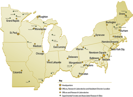
- Research Work Units: 14
- Research Locations: 25
- Experimental Forests: 24
- Employees: 403
- Web: www.nrs.fs.fed.us
- Twitter: @usfs_nrs
You can also view our Research Highlights from 2013