
Official websites use .gov
A .gov
website belongs to an official government organization in the
United States.
Secure .gov websites use HTTPS
A lock
(
) or https:// means you've safely
connected to the .gov website. Share sensitive information only
on official, secure websites.


Maps & Publications
 Maps
Maps
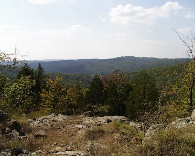
Whether you "hit the trail" on foot, horseback, or mountain bike, it's a good idea to do a little homework first. One excellent planning tool is a good map.
Mark Twain National Forest has different map products available;
- USGS Topographic Maps - Scale of these maps is approximately 2.4 inches per mile. There are 168 Topographic Maps covering the Mark Twain National Forest. See below info on ordering.
- Forest Visitor Maps - at 1/2" = one mile scale, depict entire Ranger Districts. A set of four Forest Visitor Maps covers all six administrative units. Maps are sold at the Supervisor's Office and at all District Offices. See below info on ordering. Currently the ACW Ranger District Visitor Map is also available electronically for purchase for $4.99 in the Avenza app.
- Motor Vehicle Use Maps - shows the roads and trails that are open to vehicular traffic. This map contain only roads information, with limited key features. These are large files.
- Trail Maps - Electronic files which are available for download and are geo-referenced.
- Walk-in Turkey Hunting Maps - Each year the Mark Twain National Forest sets aside special walk-in turkey hunting areas that are closed to motor traffic.
Ordering Maps
To order maps by mail, please print the order form and mail it with check or money order for exact amount. Credit card sales are accepted over the phone.
Recreation Maps
Interactive Visitor Map
Interactive Visitor Map shows recreation areas and roads on all national forests. The map is now available for mobile download, look for "Visitor Map: Map of Forest Service Lands".
Discovery Agents
Discovery Agents is a mobile game visitors of all ages can play at the Caney Picnic Area on the Ava unit of the Ava/Cassville/Willow Springs Ranger District of the Mark Twain National Forest. The game is designed for visitors to get outside, move and engage. Discovery Agents can be compared to Pokemon GO, but with an educational twist. The Glade Top Trail – Caney Picnic Area mission site has 10 stops where Agent District Ranger Roadrunner escorts you to challenges to answer and receive tokens for correct answers. Along with the challenges, there is educational information to read and learn about Forest Service management and history of the area. Discovery Agents is an application that can be downloaded to mobile devices and should be downloaded before you come to the site. Once at the site, GPS is all that is needed. A tutorial to learn about Discovery Agents is included after it is downloaded.

OnCell
This App is meant to help you get out in the field and start exploring the Mark Twain National Forest.
Decide whether you want to Explore an area to see what it has to offer, or if you want to Explore by activity to hit the ground running (or paddling, or camping, etc.)!
We recommend that you also download the Avenza Application before venturing out, so you can open maps within this program and find out where you are located.
This app is meant to be an introduction to the Forest--there are many hidden gems across the 1.5 million acre forest not highlighted in this app. Please visit our website at to see all the recreation opportunities available.
No cell service is required to use most functions of this application, so this can make a handy pocket guide when in the field for visiting site locations highlighted within the app. Note: Some devices require cell service to track location, so GPS functions may not work in areas without cell coverage unless your device has a GPS antenna built in.
Motorized Trails
- Chadwick Area
- Trail System Map (pdf)
- Brochure (pdf)
- Sutton Bluff ATV, UTV and Motorcycle Trail Map (pdf)
National Scenic Byways
- Audubon Trail - GeoPDF map available through the Avenza app.
- Bateman Trail
- Berryman Trail - GeoPDF map available through the Avenza app.
- Blue Ridge Trail
- Brochure
- Kiosk Map (pdf)
- Detailed Trail Map - PDF | Avenza Map
- Cedar Creek Trail
- Cole Creek Trail
- Council Bluff Trail
- Crane Lake Trail
- Kaintuck Hollow Trail
- Ridge Runner Trail
- Swan Creek Trails
- Wolf Creek Trail
(1 page info sheet with location map)
*Not Georeferenced
- Bell Mountain Wilderness and Trails
- A printable brochure is available for download
- Trail System Map (printable)and Trail System Map available on the Avenza app.
- Devil Backbone Wilderness and Trails
- Hercules Trail Wilderness and Trails
- Irish Wilderness and Trails
- A printable brochure is available for download
- Trail System Map (printable)and Trail System Map available on the Avenza app.
- Paddy Creek Wilderness and Trails
- Piney Creek Wilderness and Trails
- Rockpile Mountain Wilderness and Trails
- A printable brochure is available for download
- Trail System Map (printable)and Trail System Map available on the Avenza app.
Topographic Maps
18 separate maps: Selmore, Chadwick, Keltner, Day, Garrison, Bradleyville, Brownbranch, Smallett, Wasola, Forsyth, Hilda, Protem NE, Thornfield, Wilhoit, Protem SW, Protem, Theodosia, Isabella

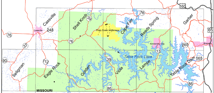
11 separate maps: Cassville, Shell Knob, Cape Fair, Reeds Spring, Garber, Seligman, Eagle Rock, Golden, Viola, Lampe, Table Rock Dam
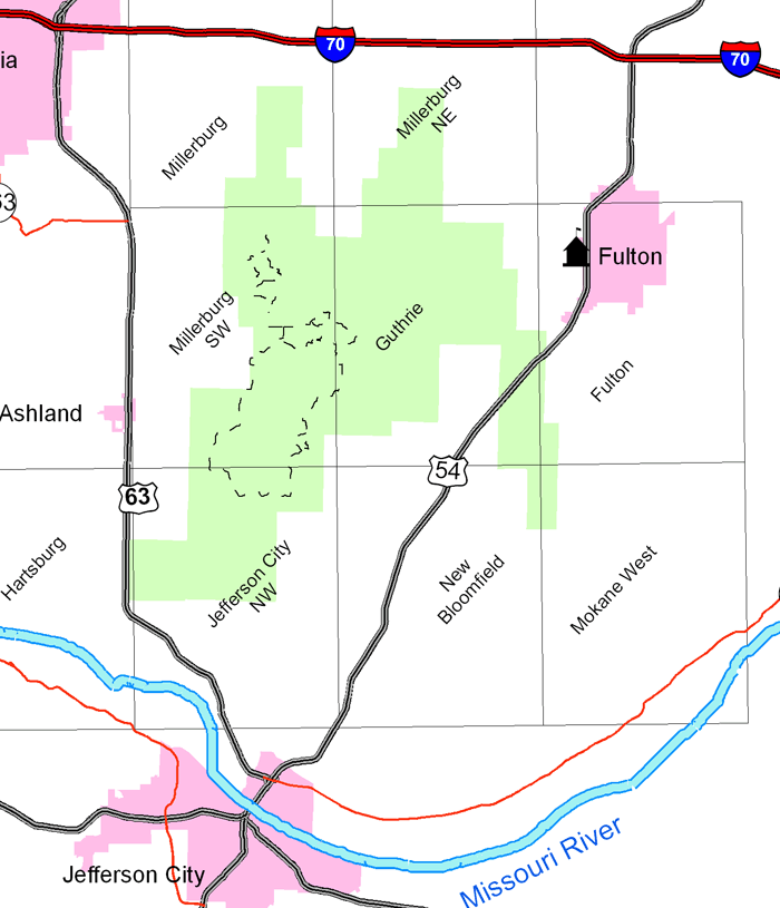
9 separate maps: Millersburg, Millersburg NE, Millersburg SW, Guthrie, Fulton, Harsburg, Jefferson City NW, New Bloomfield, Mokane West
17 separate maps: Coffman, Minnith, Iron Mountain Lake, Womack, Parker Lake, Ironton, Lake Killarney, Rhodes Mtn, Fredericktown, Higdon, Patton, Glover, Des Arc NE, Rock Pile Mtn, Cherokee Pass, Marquand, Hurricane

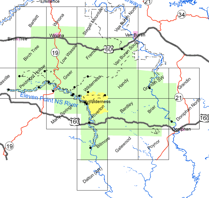
23 separate maps: Bartlett, Winona, Stegall Mtn, Van Buren North, Birch Tree, Low Wassie, Fremont, Van Buren South, Thomasville, Piedmont Hollow, Greer, Wilderness, Handy, Grandin SW, Grandin, Many Spring, Riverton, Bardley, Briar, Doniphan North, Billmore, Gatewood, Poynor
25 separate maps: Dixon, Newberg, Rolla, Ozark Springs, Waynesville, Devils Elbow, Kaintuck Hollow, Yancy Mills, Drynob, Brownfield, Bloodland, Big Piney, Flat, Edgar Springs, Drew, Winnipeg, Roby, Slabtown Springs, Beulah, Competition, Manes, Roubidoux, Success, Prescott, Dawson

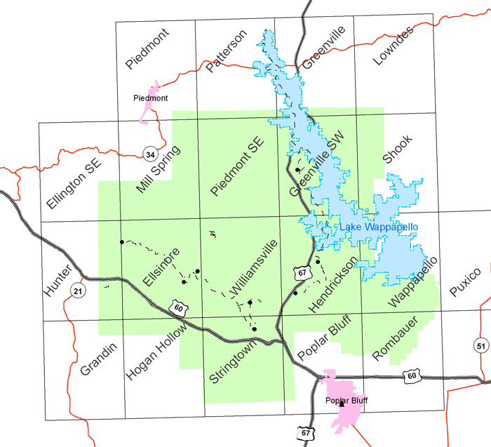
19 separate maps: Piedmont, Patterson, Greenville, Lowndes, Ellington SE, Mill Spring, Piedmont SE, Greenville SW, Shook, Hunter, Ellisnore, Williamsville, Hendrickson, Wappapello, Grandin, Hogan Hollow, Stringtown, Poplar Bluff, Rombauer
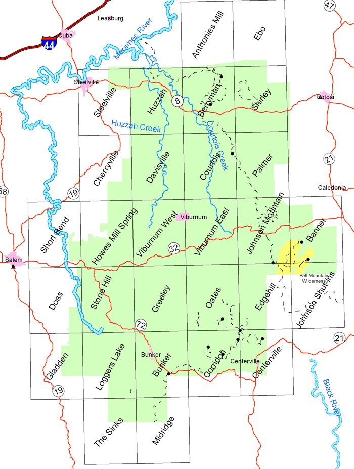
33 separate maps: Leasburg, Onondaga Cave, Anthonies Mill, Ebo, Steelville, Huzzah, Berryman, Shirley, Potosi, Cherryville, Davisville, Courtois, Palmer, Belgrade, Short Bend, Howes Mill Spring, Viburnum West, Viburnum East, Johnson Mountain, Banner, Doss, Stone Hill, Greeley, Oates, Edgehill, Johnson Shut-ins, Gladden, Loggers Lake, Bunker, Corridon, Centerville, The Sinks, Midridge
13 separate maps: Mtn Grove South, Cabool SW, Cabool SE, Willow Springs North, Vanzant, Nichols Knob, Dyestone Mtn, Willow Springs South, Dora, Siloam Sprs, Pomona, Cureall NW, Potterville

Motor Vehicle Use Maps
These 9 maps are legal documentation displaying the roads and trails that are open to public motor vehicle use. If a road or trail you see on the ground does not appear on the maps, it means that it is not open to public vehicular use. The maps are reviewed and updated annually.
All 9 of the Motor Vehicle Use Maps (MVUMs) for the Mark Twain National Forest are available for review at the Supervisor’s Office in Rolla. Copies of individual unit maps are available, free of charge, at the district office for that unit.
Please contact the Ava Ranger District Office for maps of the Ava, Cassville, and Willow Springs units; the Eleven Point Ranger District Office in Doniphan for maps of the Eleven Point unit; the Houston Ranger District Office in Houston for maps of the Houston, Rolla, and Cedar Creek units; the Potosi Ranger District Office in Potosi or the Salem Ranger District Office in Salem for maps of the Salem/Potosi and Fredericktown units; and the Poplar Bluff Ranger District Office in Poplar Bluff for a map of the Poplar Bluff unit.
The motor vehicle use maps are black and white single-purpose maps, and they do not provide much detail. They are not appropriate maps for most recreation orientation use (hunters, hikers, etc.). The maps only show open roads, county lines, and a few other important features.
There are no major changes to where motorized vehicles are permitted in the Mark Twain National Forest – motor vehicles have been restricted to using only open Forest System roads and the designated motorized trail systems (Chadwick and Sutton Bluff) since the 1980s. Vehicles on roads must be in compliance with Missouri state motor vehicle regulations; motorcycles and ATVs ridden on the Chadwick and Sutton Bluff Trails must have a valid Mark Twain National Forest permit.
Existing national forest maps that show both open and closed roads, trails (hiking, biking, horseback riding, as well as the two trail systems open to motorcycles and ATVs), recreation sites, and some features outside of the National Forest boundaries are available for purchase. These maps show much greater detail than the MVUMs do.
- Ava Unit
- Cassville Unit
- Cedar Creek Unit
- Eleven Point Unit
- Fredericktown Unit
- Houston/Rolla Unit
- Poplar Bluff Unit
- Salem/Potosi Unit
- Willow Springs Unit
Please Note: The downloadable Adobe 10 PDF files are quite large.
Printing Tip: To print a section of the PDF files, zoom in to the area. Next select file, print, current view and ok.
Walk-in Turkey Hunting Maps
Forest Service Motorized Vehicle Use Maps (MVUM) lists specific Forest Service roads open to vehicle traffic and the dates the road is open/closed to vehicle traffic.
Hunting is allowed on most of the 1.5 million acres of the Mark Twain National Forest, which is located in central and southern Missouri. The National Forest and private land are intermingled, hunters must be sure they are either on national forest land or have permission from the private land owners to hunt on private land.
All hunters must have a valid Missouri hunting license and follow all state hunting laws and regulations.
Walk-In Hunting Areas Maps and Wilderness Areas
Some areas are located in multiple counties, so will show under each county they are located in.
Barry County
Christian County
Douglas County
Howell County
Ozark County
Stone County
Taney County
Boone and Callaway Counties
Carter County
Oregon County
Ripley County
Shannon County
Pulaski County
Phelps County
Texas County
Iron County
Madison County
Washington County
Dent and Reynolds Counties
