
Official websites use .gov
A .gov
website belongs to an official government organization in the
United States.
Secure .gov websites use HTTPS
A lock
(
) or https:// means you've safely
connected to the .gov website. Share sensitive information only
on official, secure websites.


Maps & Publications
The US Forest Service provides several types of publications for the public. The material is available as brochures, maps, and Recreational Opportunity Guides (ROGs) on subjects such as recreation, sightseeing, wilderness, travel management, and vegetation.
Forest Maps
 Forest Service maps are available to help you plan your next adventure and enjoy your next visit. The maps are available to purchase online at the U.S. Geological Survey Store and at the Klamath National Forest Headquarters and District Offices.
-
National Forest Visitor Maps provide an overview of recreational uses, trails, roads, streams, lakes, landforms, land administration, visitor centers, facilities, campgrounds and picnic areas. The map also displays color photographs of points of interest and activities. The National Forests are mapped at the scale of 1/2 inch per mile (1:126,720) and are available online at the U.S. Geological Survey Store. Maps available in our offices include Klamath, Shasta-Trinity, and Modoc National Forests.
-
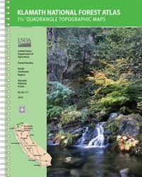
The Klamath National Forest Atlas has full-color, 8.5-inch by 11-inch topographic quadrangle maps at the 1 inch to a mile scale (7.5 minute) in a spiral-bound book for convenience (no refolding!)
-
Wilderness Maps are topographic maps that show natural features such as mountains, valleys, plains, lakes, rivers, and vegetation with contour lines depicting elevation gains and losses. Each map covers all or part of the wilderness area. Maps available in our offices include the Marble Mountain and Russian Wildernesses, Trinity Alps Wilderness, and the Siskiyou Wilderness.
-
Pacific Crest National Scenic Trail Maps provide a detailed view of the trail running from Mexico to Canada through California, Oregon, and Washington. The maps are in sections, and show the trail, access roads, streams, lakes, landforms, horse facilities, campgrounds, and trailheads for each area, as well as color photographs of points of interest and activities. The maps scale are 1 inch to a mile (1:63,360). Maps available in our offices include #6 - Klamath/South Cascades (Old Station to Seiad Valley), and #7 - Southern Oregon (Seiad Valley to Willamette Pass).
-
Other useful maps and information
Digital Maps for Mobile Devices

The Avenza Maps Mobile App, developed by Avenza Systems, Inc., is available as a free download for both Apple and Android operating systems. The app provides access to Forest Service maps, such as Motor Vehicle Use Maps (which are free), national forest atlas pages ($.99 each), and forest visitor maps ($4.99 each).
After downloading your choice of maps, the app shows your location using the GPS in your phone. Cell service is not required.
Motor Vehicle Use Maps (MVUM)
Motor Vehicle Use Maps display National Forest System routes (roads and trails) or areas designated open to motorized travel. The Motor Vehicle Use Map also displays uses allowed by vehicle class (highway-legal vehicles, vehicles less than 50 inches wide, and motorcycles), and seasonal allowances.
Smaller "2016 Color Travel Maps" are also available.
Forest Publications

Our publications fall into a few broad categories: administrative, general, recreation and research publications.
Recreation Opportunity Guides
Campgrounds
- Klamath National Forest Campgrounds
- Campgrounds on the Salmon River
- Campgrounds on the Scott River
- Campgrounds on the Goosenest Ranger District
- Campgrounds on the Happy Camp/Oak Knoll Ranger District
Wilderness
- Marble Mountain Wilderness Lakes
- Marble Mountain Wilderness Trails
- Russian Wilderness
- Trinity Alps Wilderness Trails
Hiking
Personal Use Firewood Maps
- Goosenest Ranger District
- Happy Camp and Oak Knoll Ranger Districts
- Salmon River and Scott River Ranger Districts
Miscellaneous
These are just a sampling of the types of handouts that are free at your local forest office.