
Official websites use .gov
A .gov
website belongs to an official government organization in the
United States.
Secure .gov websites use HTTPS
A lock
(
) or https:// means you've safely
connected to the .gov website. Share sensitive information only
on official, secure websites.


About the Trail
What is the Florida National Scenic Trail?
The Florida National Scenic Trail (also known as the Florida Trail or FT for short) is a congressionally-designated, long-distance hiking trail that weaves its way across Florida from Big Cypress National Preserve in the south to Gulf Islands National Seashore in the western end of Florida’s panhandle.
The Florida Trail is a national treasure, being 1 of only 11 National Scenic Trails in the country, and 1 of 3 contained entirely within a single state. The Forest Service administers five other National Scenic Trails throughout the country as part of the National Trails System. National scenic and historic trails were established as part of the National Trail System to preserve the country’s scenic, historic, cultural and natural wonders. The Florida National Scenic Trail provides the opportunity to see unique features in each of these categories.
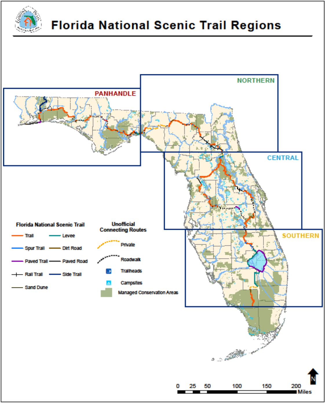
The Florida Trail is currently about 1,500 miles long. The USDA Forest Service has it divided into four main geographic regions: the Southern region, the Central region, the Northern region and the Panhandle region.
The USDA Forest Service is the official administrator of the Trail, though the FT is managed and maintained by over 30 different land managers and many dedicated volunteers, including those from the Florida Trail Association.
History
In the 1960s, the Florida National Scenic Trail was just a dream. A group of dedicated volunteers created the Florida Trail Association, whose member recognized the need for long distance hiking opportunities in Florida. These volunteers came together to create, improve, and steward what is now the Florida Trail. The first blaze of the Florida National Scenic Trail was marked in the Ocala National Forest in October of 1966, but the Trail was not officially designated as a National Scenic Trail until 1983.
Overview
To learn a little more about the trail, check out the FTA's 4-minute video that covers everything from the Florida Trail history, its goals and objectives, how it's administered and maintained, and even what the trail looks like today!
You can also explore Your Florida Trail Story Map, which takes a deeper look at where the Florida Trail really is, our Gateway Communities Program, the Junior Explorer Program, and a bit of our history. Be sure to explore both to learn everything you can about the Florida Trail!
How to Find and Use the Trail
The Florida National Scenic Trail is within one hour’s drive of most Floridians, and there are many great resources available to help you use and locate the Trail! While the FT is mostly a hiking trail, users can also camp, swim, bike, horseback ride, paddle, and picnic on some sections of the Trail. FT visitors can check with local land managers to see which uses are allowable near them.
There are many resources available to help you find and use the Florida Trail, such as the FT ArcGIS map, Forest Service kmz files, and the Florida Trail Association.
ArcGIS
You can find the Florida National Scenic Trail using your computer or smartphone via ArcGIS! The US Forest Service continually updates the ArcGIS map with current data for trail management and planning purposes. The ArcGIS map allows you to explore the trail and trail features, such as campsites and trailheads.
The ArcGIS map is available online or through the ArcGIS Explorer app.
The Florida Trail Association
For printed navigational maps, tips, and more information on hiking the Florida National Scenic Trail, you can visit the Florida Trail Association.
Visit our Maps & Publications page to learn more about how you can locate the Florida National Scenic Trail.
Recreation Opportunities on the FNST
One of the greatest aspects of the Florida National Scenic Trail experience is that it can vary greatly depending on the user’s location. From the swamps of Big Cypress to the beach walks of Gulf Islands National Seashore to the dikes and levees around Lake Okeechobee, there are vastly different environments to be found. Check out the Florida Trail brochure for some trail highlights.
FNST Activities
While hiking is the primary activity taking place on the Trail, there are many other recreation opportunities for FT visitors.
- Activities that are always acceptable on the FT:
- Hiking & wildlife viewing
- Allowed in some sections:
- Biking
- Horseback riding
- Paddling
- Camping
- Hunting
- Swimming
- Leashed dogs
It is always a good idea to check with the local land manager (i.e. the State Park Service, water management district, FWC, etc.) to find out what uses are allowed on and around your local sections of the FT. Sorry, pack animals such as goats or mules are not allowed on the trail. Florida has one of the highest rates of biodiversity in the nation, and many sensitive species call it home. Help us preserve these important habitats by following the rules set by local land managers and the US Forest Service.
Common Plants & Wildlife by Region
The flora & fauna on the FT can also vary greatly by sections of trail. Florida is home to unique environments, some of which are not seen anywhere else in the world. This means that FT users have prime access to some of the best nature and wildlife viewing opportunities in the country.
- Southern Region: Swamplands, pine flatwoods, scrub, and saw palmetto are frequently seen on the southern portions of the FT. Some of the common types of wildlife seen in this region include: alligators, cattle, panthers, Florida black bears, and many different bird species.
- Central Region: Wildlife common to this region include sandhill cranes, white-tailed deer, feral hogs, wild turkey, cattle, the Red Widow spider, Florida pine snake, black bear, and gopher tortoises. Palmetto prairies, ranch land, scrub, oak hammocks, and pine flatwoods can all be seen in the central region.
- Northern Region: Wiregrass, longleaf pine, pine plantations, hardwoods, and oak hammocks are commonly found in this region. Additionally, users can find red-cockaded woodpeckers, black bears, rabbits, wild turkey, deer, red-tail hawks, and gopher tortoises.
- Panhandle Region: Pitcher plants, hardwood hammocks, salt marsh, pine flatwoods, orchids, and dune grasses can all be found in the northern region. Users can spot bald eagle, osprey, black bears, otters, sea turtles, and piping plovers in this region.
For more information about Florida's natural flora and fauna, explore the Natural Community Ecology on the Florida Trail story map, produced in partnership with the Florida Natural Areas Inventory. The collection offers an in-depth review of each of Florida's four region's natural ecosystems and what makes them special.