
Official websites use .gov
A .gov
website belongs to an official government organization in the
United States.
Secure .gov websites use HTTPS
A lock
(
) or https:// means you've safely
connected to the .gov website. Share sensitive information only
on official, secure websites.


Maps & Publications
Forest Visitor Maps
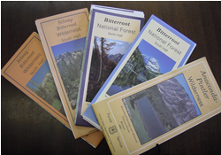 The Bitterroot National Forest offers a set of Visitor and Travel Plan maps, one for the north half of the Forest (includes the Stevensville and Darby Ranger Districts) and one for the south half (includes the Sula and West Fork Ranger Districts). These maps are printed with topographic lines at a scale of 1" to a mile and combine general forest and travel opportunity information such as roads, trails, trailheads, streams, rivers, lakes, and major peaks, as well as recreation facilities such as campgrounds, fishing access sites, cabin rentals, and picnic areas. Additionally the Bitterroot National Forest includes parts of three designated wilderness areas each with their own separate map(s): the Anaconda Pintler Wilderness, the Selway Bitterroot Wilderness, and the Frank Church River of No Return Wilderness.
Obtaining Forest Visitor Maps
Bitterroot National Forest maps, as well as many other National Forest, Grassland, and Wilderness maps, may be purchased at any of our local forest office's or online at the USGS Store.
Motor Vehicle Use Maps (MVUM)
Motor Vehicle Use Maps (MVUM) for the Stevensville, Darby/Sula and West Fork Ranger District are available. Paper copies are available at District Offices. These maps are free to the public.
The MVUM display National Forest System routes including roads, trails and areas designated open to motorized use. If the route or area is not shown on the MVUM, the route or area is closed to motor vehicles.
Printed copies of the MVUM are available at the corresponding District Ranger's and National Forest or Grassland Supervisor's Offices.
To view a MVUM Map online, click on a link below. These are large .pdf files, so they may take several minutes to load.
- Bitterroot NF MVUM Stevensville RD - updated May 2022 (3.9MB)
- Bitterroot NF MVUM Darby RD - updated May 2022 (4.7MB)
- Bitterroot NF MVUM West Fork RD - updated May 2022 (5.6MB)
- Bitterroot NF MVUM Sula RD - updated May 2022 (6MB)
- 2016 Bitterroot NF Over-Snow Motor Vehicle Use Map (OSMVUM) North (6,206 KB)
- 2016 Bitterroot NF Over-Snow Motor Vehicle Use Map (OSMVUM) South (5,512 KB)
Avenza
 If you own a mobile device such as an iPad, iPhone, iPod Touch or Android (4.0.3 or newer), you can take the Bitterroot National Forest MVUMs with you.
1. Download the free Avenza PDF Maps app to your mobile device.
2. Once you have Avenza on your mobile device, use your device to download the maps at pdf-maps.com while running the App. Select 'Get Maps' and search for "Bitterroot MVUM" or "Bitterroot OSVUM". There are 4 MVUM maps (Stevensville, Darby, West Fork, and Sula) and 2 OSVUM maps (North Half, South Half). QR codes are also available to take users directly to each MVUM district map in the Avenza map store. Click here for the QR codes.
With the app and maps installed on your mobile device, you will be able to:
- View your location on the PDF MVUM using the built-in GPS device
- Measure distances and areas
- Plot waypoints
- View maps offline
- And more…
Through a no-cost contract with Avenza Systems, Inc., the USDA Forest Service has made electronic versions of its Motor Vehicle Use Maps (MVUMs) available as free downloads for smartphones and tablets.
USGS Maps
The USGS's most familiar product is the 1:24,000-scale Topographic Quadrangle Map. This is the primary scale of data produced with the greatest detail for an area. USGS Topo Quad Maps are 22"x27". Each Ranger District on the Forest carries the USGS topographical maps located on their respective districts. They are also available for purchase from the USGS Store.
Forest Publications
- Bass Creek Recreation Area Day Use Trail
(PDF 661Kb) - Bitterroot - Big Hole Road - A Driving Guide to the old Gibbons Pass Road
(PDF 133Kb) - Lick Creek Interpretive Auto Tour Brochure - A seven mile drive thru the Lick Creek Demonstration/Research Forest
(PDF 2.22MB) - Magruder Road Corridor - A guide to the historic Magruder Road
(PDF 5.35MB) - Saddle Mountain - A 360�View
(PDF 6.14MB) - Wildland Fire Use - Bitterroot National Forest
Regional Publications
- Recreational Prospecting - Rockhounding and Fossil Hunting in the Montana National Forests of the Northern Region
Other Publications
- After the Fire - A Landowners Guide to Programs and Services for Assistance; A publication of the Montana DNRC - January 2005
