
Official websites use .gov
A .gov
website belongs to an official government organization in the
United States.
Secure .gov websites use HTTPS
A lock
(
) or https:// means you've safely
connected to the .gov website. Share sensitive information only
on official, secure websites.


Fire Management
For Current Wildfire Activity
For more information about current wildfires, please see: InciWeb.
 The Beaverhead-Deerlodge National Forest has a large and diverse fire program. With a variety of fuel types and well-established historical fire patterns, the forest has proven to be a challenging environment to manage.
The Beaverhead-Deerlodge National Forest lies within a forest system where natural fire occurrence is common. The Forest also provides for a variety of recreational and management activities which sometimes result in unwanted human-caused fires.
Fire management is an integral part of Land and Resource Management on the Beaverhead-Deerlodge National Forest. Fire plays a natural role in achieving long-term goals of ecosystem health.
Wildland fire management decisions and resource management decisions go hand in hand and are based on approved Fire Management and Land and Resource Management Plans. Wildland fire, as a critical natural process, may be reintroduced into the ecosystem where human life, property, or resource values are not at risk.
In all cases, protection of human life is the first priority in wildland fire management. Property and resource values are the second priority, with management decisions based on values to be protected. For more information regarding fire management on the Beaverhead-Deerlodge National Forest:
Fire Prevention
Firefighters count on you to do your part to reduce the risk of wildfires.
YOU can make all the difference in reducing the risk of unwanted wildland fires!
It may be as simple as NOT lighting that campfire when conditions are dry and windy,
or NOT throwing your cigarette butt out the car window,
or NOT leaving a pile of burning trash unattended.
Pay attention to current camp fire or brush burning restrictions.
More information about fire prevention and education visit Smokey Bears Website
If you are a property-owner, there are several steps you can take to reduce fire risks.
Thousands of communities are located in fire-prone areas. Residents must take action to adapt their communities to fire. These actions will help to reduce risks to their homes and improve the safety of the public and firefighters.
It is the responsibility of property owners to clear brush, trees and other flammable material away from your house BEFORE a wildfire occurs.
The Forest Service partners with several other agencies to promote the FireWise Program which teaches property owners how to be proactive about reducing potential losses in wildfire-prone areas. For more information, see National Fire Protection Association - Firewise Website
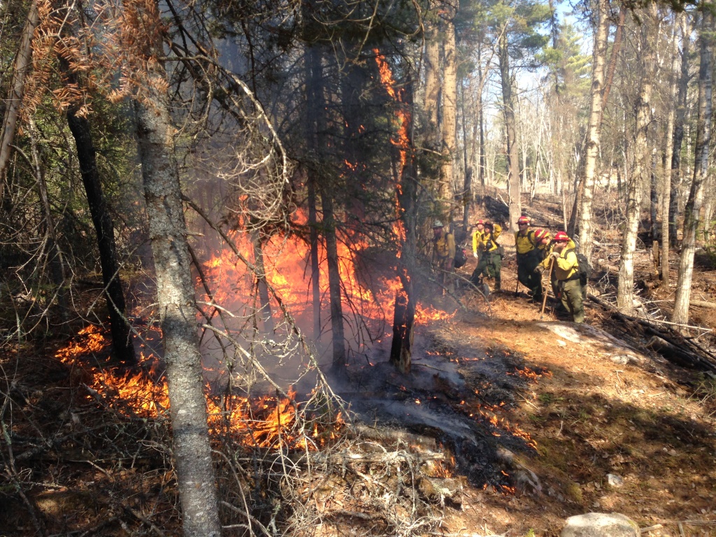
Prescribed Fire
Prescribed Fire is any fire ignited by management actions to meet specific objectives. Prescribed fire is used as a tool for fuels reduction, vegetation management, and wildlife habitat maintenance on the Beaverhead-Deerlodge National Forest. Planning a prescribed burn begins months in advance. A written, approved prescribed fire plan must be completed, control measures such as firelines must be established, notification to the public must be made, and mitigation measure to protect values at risk must be set prior to ignition. Visit the national website for more information on prescribed fire within the Forest Service. The below table details units that may be ignited in spring of 2024, and additional information on these prescribed burns can be found in this year's press release under 'News".
|
Prescribed Fire Unit |
Acres |
Project Location |
|
French Creek Units 5 and 6 |
250 |
Dillon RD: 6 miles northwest of Argenta by Kelly Reservoir |
|
Black Mountain |
203 |
Dillon RD: 5 miles northwest of Argenta |
|
Virtual Lost Unit 24 |
120 |
Dillon RD: 10 miles north of Dillon |
|
Wisdom Administrative Site |
62 |
Wisdom RD: Local FS workstation compound |
|
Steel Creek Administrative Site |
80 |
Wisdom RD: Local FS admin site/compound |
|
Jackson Administrative Site |
130 |
Wisdom RD: Local FS admin site/compound |
|
Basin Creek |
571 |
Butte RD: 5 miles south of Butte, around the Basin Creek Reservoir watershed. Along Roosevelt Drive and on Moose Creek Road (FS RD 84) in the Highland Mountains. |
|
Blacktail Headwaters |
945 |
Butte RD: 7 miles southeast of Butte, along Limekiln Road. |
|
Red Rocks Units 406, 407, 427, 438, 439, 501, 502, 503, 504, 505, 506, 507, 509, and 510. |
880 |
Butte RD: North of Butte in Red Rock Creek and Boulder River area. West of the Bernice Exit off I-15. Smoke from the 400-series units may be visible from the Interstate. |
|
Gravelly Mountain Range - piles |
|
Madison RD: south of Ennis, including Johnny Gulch NFS Road 324, Warm Springs NFS Road 163/Gravelly Range NFS Road 290, and Jackpine Gulch NFS Road 1209. |
|
Conklin Aspen |
1,302 |
Madison RD: 53 miles south of Ennis in the Antelope Basin area near Conklin Lake and NFS Road 3931. |
|
Spring Branch Aspen |
815 |
Madison RD: 53 miles south of Ennis in the Antelope Basin area near Conklin Lake and NFS Road 3931. |
|
Idaho Creek |
481 |
Madison RD: 11 miles south of Alder and 5 miles east of Ruby Reservoir, along NFS Road 8321. |
|
Flint Foothills Units 1, 5, 30, and 32 |
206 |
Pintler RD: 10 miles southeast of Drummond |
|
Flint Foothills Units 7B and 8B |
1,650 |
Pintler RD: 10 miles southeast of Drummond |
|
Lone Pine Unit Rally Way |
144 |
Pintler RD: 12 miles southeast of Philipsburg |
|
Gold Coin Units 6, 9, and 10 |
477 |
Pintler RD: 2 miles southwest of Maxville |
Burn Preperation Information
Site-specific burn plans are developed for each prescribed burn. Burn plans must be developed according to national standards.
During the planning phase, specialists conduct resource surveys to identify areas with cultural or natural resources that could be affected and need to be protected during burns. The burn plan includes measures to protect sensitive resources including threatened, endangered, or sensitive species. For example, if an eagle’s nest is present near or within a prescribed fire area, vegetation may be cleared around the nest and sprinkler systems may be set up to protect the nest. Specialists also evaluate fuel characteristics, topography, the location of buildings, and ways to mitigate undesirable impacts such as smoke. Ideal weather conditions are also identified. A step-by-step plan to light the fire and then hold the control line by reinforcing it with, for instance, water from hose lines or water dropped from helicopters. Burn plans are finalized with reviews from other resource specialists and line officers.
Part of the preparation for a prescribed burn may include clearing control lines, establishing helispots (temporary landing places for helicopters), and scheduling back-up crews and equipment. Public notification and coordination with other agencies is also part of preparation.
Prescribed burns are usually ignited by either hand crews on the ground with drip torches or explosives or by air with a helicopter or airplane or a combination of these methods. Following ignition, fire crews monitor the progress of the burn, patrol to observe behavior of the fire and take actions, when needed, to make sure that the fire stays within the predetermined unit boundaries. After the unit has burned, fire crews mop-up (put out hot spots) and patrol the area to make sure the fire is out.
Prescribed Fire Plans identify weather and fuel conditions appropriate for conducting prescribed fire. These conditions are a balance of the fire behavior need to meet objectives and the ability for holding resources to control the fire. Fire behavior modeling programs are used to identify the weather and fuel conditions that produce the fire behavior necessary to meet those conditions. Weather and fuel parameters that are given additional consideration include:
- Wind: Most large fires are a result of high wind conditions. Eye level wind speeds in excess of 25 miles per hour have been found to be problematic at times. Therefore, when planning a prescribed burn wind conditions are continually monitored.
- Drought: The other variable that has been present during large fire events is dry fuel conditions. Prolonged lack of moisture produces drought conditions which results in dry fuel conditions. Drought codes are monitored to ensure fuel conditions are not too dry. For more information on drought indices visit the NOAA website.
There are a limited number of days each year that meet the conditions appropriate to conduct prescribed burning. On a give year there are 10-20 days which prescribed fire can be conducted.
Typically, prescribed fire conditions are most appropriate in early spring and fall. In early spring, fuel conditions are drier because vegetation is coming out of dormancy. Once green-up occurs, vegetation is at full water content and holds moistures making it difficult to burn. In the fall, vegetation is beginning to go into dormancy and water content is beginning to drop off. Also in the fall time, the shorter days create condition which do not support high intensity fire or prolonged burning which can be problematic from a control stand point.
The following list summarizes the steps taken to keep the public informed of planned prescribed burns in the BWCAW. Most of these steps are followed for all prescribed burns.
- Burn Plan: Site-specific public notifications are identified for each prescribed burn unit during the preparation of the burn plan.
- Yearly: A summary and map of planned prescribed burns is prepared annually. The summary and map are posted on the forest website, and provided via a network that includes Forest Service personnel, Reserve America, cooperators, other businesses, partner agencies, media, private organizations, community contacts, and the tourism industry. Meetings are held with residents, businesses, and organizations in advance of prescribed burns to present information and answer questions.
- Week Prior to Burning: Advisories will be posted via the notification network, in campgrounds, entry points and at all permitting offices.
- 1-2 Days Prior to Burning: local residents, business, and cooperators are notified.
- During a Prescribed Burn: Updates will be provided to the public as available.
Wildfires
The Forest Service has managed wildland fire for more than 100 years. But how we do it - why, when, and where we do it - has changed. Fire managers have the ability to choose from the full spectrum of fire management options, from prompt suppression to allowing fire to function in its natural ecological role. There are Forest Service-specific and interagency policies and study recommendations that guide fire management decisions.
What hasn't changed is close collaboration with Tribal, state, local, and other federal agencies as well as work with our local communities to reduce risks and protect lives.
Learn more from our National Office
Wildland fire knows no boundaries. Local, state, tribal and federal firefighters all work together to manage wildfires. Pooling our strengths and resources helps us to be more effective and keeps our costs down.
The Incident Command System is an interagency group with state and federal partners that cooperate in management of wildfire and all risk incidents and provide standard procedures, practices and information to facilitate, coordinate and support actions on incidents.
Community Wildfire Protection Plans (CWPPs) reduce wildland fire risks across larger areas in a shorter amount of time by prioritizing and coordinating efforts across jurisdictions.
Please visit the following links for more information:
- St Louis County Wildfire Protection Plan
- Cook County Wildfire Protection Plan
- Lake County Wildfire Protection Plan
The National Interagency Fire Center (NIFC) is the focal point for coordinating the mobilization of resources for wildland fire and other incidents throughout the United States.
About Balsam Fir:
Fire and the Wildland Urban Interface:
Forest Management and Fire:
- Difference Engine: Fire on the Mountain (Babbage, Science and Technology)
- "Let it burn" - Prescribed Fires Pose Little Danger to Forest Ecology, Study Says (UC Berkely study)
- The Effects of Forest Fuel Reduction (USDA Forest Service)
- Science Basis for Changing Forest Structure to Modify Wildfire Behavior and Severity (USDA Forest Service)
Smoke Management:
-
Fire

Learn more about ______.
-
Closures and Alerts

Current Forest Orders can be viewed below under Alerts and Closures.
-
Maps

The Beaverhead-Deerlodge offers a variety of map products to help you plan your next adventure.