
Official websites use .gov
A .gov
website belongs to an official government organization in the
United States.
Secure .gov websites use HTTPS
A lock
(
) or https:// means you've safely
connected to the .gov website. Share sensitive information only
on official, secure websites.


Planning
4FRI Planning
- 4FRI Rim Country Project
- Status: Complete (2022)
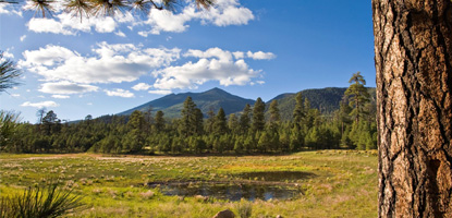
- Location: Lakeside and Black Mesa Ranger Districts on the Apache-Sitgreaves National Forests, Mogollon Rim and Red Rock Ranger Districts on the Coconino National Forest, Payson and Pleasant Valley Ranger Districts on the Tonto National Forest
- 1St 4FRI Environmental Impact Statement
- Planning (NEPA) Status: Complete (2010 to 2015)
- Location: Williams and Tusayan Ranger Districts (Kaibab NF) and Flagstaff Ranger District (Coconino NF)
- Analyzed 1 million acres; approved restoration activities in 580,000 acres
- 4FRI Rapid Assessment Report
- GIS data available under the GIS section
- Other restoration projects within 4FRI
- Planning (NEPA) Status: Complete, Underway, and Future
- Location: various locations throughout the four forests
4FRI Projects Map - a footprint of NEPA projects within the 4FRI project area.
All of the above are part of 4FRI. Within the 2.4 million-acre footprint of the Initiative are multiple projects, which propose a suite of restoration activities, to be implemented through a variety of methods.
Features
FEIS Story Map
This story map is designed as a supplement to the final environmental impact statement (FEIS) for the Rim Country project.
Geospatial Data
Geospatial data for used in the development of the 4FRI Rim Country Project analysis.

