Back | Next | Home
Missoula Technology &
Development Center
|
Table
of Contents Back | Next | Home |
Missoula Technology & Development Center |
Trail Foundation (continued)
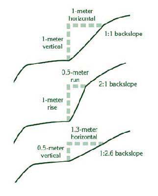
BackslopeThe backslope is the excavated, exposed area of the trailway above the tread surface. Backslopes range from near vertical (in rock) to 1:2 in soils having little cohesion. Backslopes cannot be steeper than the exposed material's ability to stay put during typical climatic conditions. Most inexperienced crews construct backslopes that exceed the parent material's angle of repose. Translation? The slope usually fails within a year, blocking the tread. A second option is to construct a crib wall and use fill to support the entire tread surface. This can be less obtrusive than huge backslope excavations and more stable, if the wall is well constructed. Much less backslope, if any, may be needed.
FillslopeThe fillslope is that area of the trail below (downslope from) the tread surface. A full–bench tread, of course, will not have any fill associated with this side of the trail. Fillslopes are critical. If you take care of the downhill side of the trailway, you'll avoid the vast majority of problems associated with trail maintenance. Borrow PitsOften you will need fill material. The hole you dig is called a borrow pit. It should be as close to the work site as possible, but screened from view. The material in the pit also needs to be suitable for the desired use. Good choices are soils with a balanced mixture of different size particles. Sand and gravel work well. So do small, well–graded angular rocks. Compare existing trail tread materials with borrow sources. Consider the proportions of gravel, sand, and fines. Individual "fine" particles are not visible to the naked eye and are classified as silt or clay. If the proportions of gravel, sand, and fines are similar, you can expect the borrow materials to perform as well as the existing trail tread materials. If the borrow source has a smaller proportion of fines, you can expect better performance under wet conditions. Soils from bogs are normally not suitable for tread fill because they lose strength when they become wet. These dark organic soils are identified by musty odor when damp. In temperate parts of the country you'll want to avoid organic soils. In the arid Southwest, however, organic material can be added to dry clay to keep it from blowing away. Creek bottoms that are replenished by storms and seasonal water flow, and the base of slopes or cliffs where heavy runoff or gravity deposit sand and gravel, are good places to look. Don't destroy aquatic or riparian habitat with your pit. Save all squares of vegetation removed from the top of the pit. You'll need them for restoration. Place them in the shade and keep them moist by covering them with wet burlap. To rehabilitate, grade the pit out to natural contours with topsoil and debris, then revegetate. Camouflage the area and access trails with boulders and dead wood. |
|||
|
|
|||
|
|
Missoula Technology & Development Center |
||
|
|
|||
|
|
|||
|
Visitor |
|||