
Official websites use .gov
A .gov
website belongs to an official government organization in the
United States.
Secure .gov websites use HTTPS
A lock
(
) or https:// means you've safely
connected to the .gov website. Share sensitive information only
on official, secure websites.


Marble Mountain Wilderness
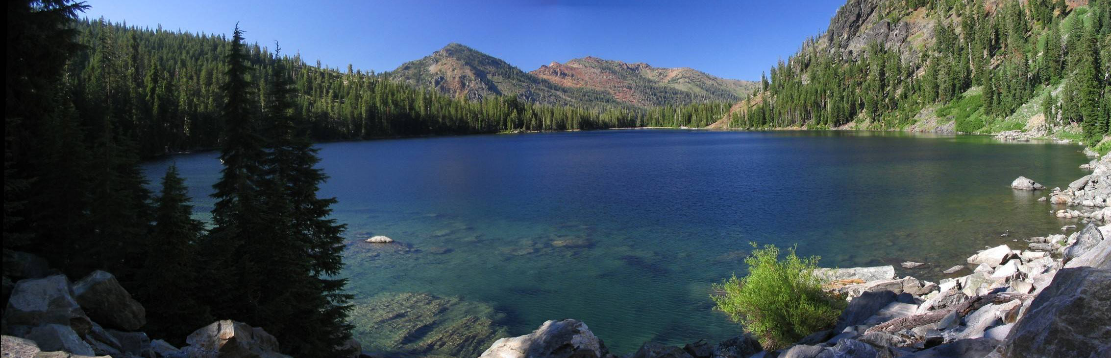
Photo of Cliff Lake copyrighted, used by permission of Deems Burton
The Marble Mountain Wilderness has been recognized for its wild values for generations. This area was originally designated as a Primitive area in 1931 and is one of the original Wilderness Areas designated by the 1964 Wilderness Act.
Craggy peaks, deep canyons cloaked in conifer forests, abundant meadows, Wild and Scenic River segments, and 89 lakes highlight this 225,000-acre area. Many of the peaks exceed 6,000 feet in elevation, with Boulder Peak the highest at 8,299 feet. There are also fascinating geological features, including Marble Mountain, a stark, red-and-gray marbled peak. Here one can travel through old growth conifer forests with diverse species: low and mid-elevation species include Douglas fir, sugar pine, and white fir; higher elevation species include Shasta fir, whitebark pine, foxtail pine, and mountain hemlock. You will find alpine meadows, lakes in glacial cirques, and bare rock at higher elevations. Black bear, black-tailed deer, and many other species of wildlife inhabit this Wilderness.
Numerous trailheads and an extensive trail network provide access to the Wilderness, offering both day hikes to lakes and longer multi-day loop trips. The Pacific Crest Trail also crosses the crest of the Marble Mountains for 32 miles from south to north.
Marble Mountain Wilderness-Permits and Regulations
Wilderness Permits are not required for trips into the Marble Mountain Wilderness.
A California Campfire Permit is required if you use either a stove or a fire and is available at any Forest Service or Cal-Fire office in California, as well as online.
Travel in wilderness is restricted to on foot, on horseback, on skis or showshoes, or in paddle rafts/kayaks. All means of mechanized transport are prohibited in wilderness except for wheelchairs needed by mobility impaired persons.
Wilderness regulations are listed here.
Marble Mountain Wilderness Trails on the Klamath National Forest
There are over 600 miles of trails in the “Marbles” ranging from well-maintained routes like the Pacific Crest National Scenic Trail (PCT) to steep little-used paths. Trail signs in wilderness areas are intentionally kept to a minimum to enhance the wilderness experience, so a good topographical map is a must.
Forest Service maintenance of the trail system depends on several factors: more developed trails are maintained more often; whether the trail leads to a popular destination; whether a trail is in are area recently burned by wildfire; whether there is available funds for trail crews; and the efforts of partners and volunteers. On some trails, especially early in the season, you may be forced to make detours around fallen trees and other obstacles.
Let'er Buck Trailhead
- Let'er Buck Trail
- Intersecting Trails
- Haypress Trail
Haypress Trailhead
- Haypress Trail
- Intersecting Trails
- Let’er Buck Trail
- Bridge Creek Trail
- McCash Loop Trail
- Secret Lake Trail
- Ukonom/Cuddihy Lakes Trail
Stanshaw Meadow Trailhead
- Stanshaw Meadow Trail
- Intersecting Trails
- Ten Bear Trail
- McCash Loop Trail
- Haypress Trail
Ten Bear Trailhead
- Ten Bear Trail
- Intersecting Trails
- Stanshaw Trail
Johnson’s Hunting Ground Trailhead
- Johnson’s Hunting Ground Trail
- Intersecting Trails
- Tickner Creek Trail
- Ukonom/Cuddihy Lakes Trail
Norcross Trailhead
- Elk Creek Trail
- Lower Bear Lake Trail
- Intersecting Trails
- Granite Creek Trail
- Rainy Valley Creek Trail
- Marble Mountain Gap Trail
- Pigeon Roost Trail
Bear Lake Trailhead
- Bear Lake Trail
- Intersecting Trails
- Pacific Crest Trail
Cold Springs/Huckleberry Mtn. Trailhead
- Pacific Crest Trail (Big Ridge Trail)
- Intersecting Trails
- Tyler Meadows Trail
- Bear Lake Trail
Tyler Meadows Trailhead
- Tyler Meadows Trail
- Intersecting Trails
- Kelsey Creek Trail
- Pacific Crest Trail
- Bear Lake Trail
Kelsey Trailhead
- Kelsey Creek Trail
- Intersecting Trails
- Pacific Crest Trail
- Paradise Lake Trail
Paradise Lake Trailhead
- Paradise Lake Trail
- Intersecting Trails
- Pacific Crest Trail
- Kelsey Creek Trail
Box Camp Trailhead
- Box Camp Trail
- Intersecting Trails
- Pacific Crest Trail
Lover’s Camp Trailhead
- Canyon Creek Trail
- Intersecting Trails
- Red Rock Trail
- Deep/Wright Lakes Trail
- Pacific Crest Trail
- Little Elk Lake Trail
- Sky High Lake Trail
- Cold Springs Camp Trail
Boulder Creek Trailhead
- Boulder Creek Trail
- Intersecting Trails
- Deep/Wright Lakes Trail
- Red Rock Trail
Big Meadows Trailhead
- Big Meadows Trail
- Intersecting Trails
- Calf/Long High Lake Trail
- Wrights Lake Trail
Shackleford Trailhead
- Shackleford Trail
- Intersecting Trails
- Cliff Lake/Campbell Lake Trails
- Calf Lake/Long High Lake Trail
- Pacific Crest Trail
Mill Creek Ponds Trailhead
- Mill Creek Ponds Trail
Etna Mill Creek Trailhead
- Etna Mill Creek Trail
- Intersecting Trails
- Pacific Crest Trail
Etna Summit Trailhead
- Pacific Crest Trail
Mulebridge Trailhead
- North Fork Trail
- Intersecting Trails
- Right Hand Fork Trail
- Bug Gulch Trail
- Lake of the Island Trail
- Abbot Lake Trail
- Horse Range Trail
Little North Fork Trailhead
- Little North Fork Trail
- Intersecting Trails
- Garden Gulch Trail
- Devil’s Canyon Trail
- English Peak Trail
- Pine Lake Trail
- Wild Lake Trail
- Ethel Lake Trail
Garden Gulch Trailhead
- Garden Gulch Trail
- Intersecting Trails
- Portuguese Peak Trail
- Little North Fork Trail
Portuguese Peak Trailhead
- Portuguese Peak Trail
- Bug Gulch Trail
- Intersecting Trails
- Garden Gulch Trail
Wooley Creek Trailhead
- Wooley Creek Trail
- Intersecting Trails
- Bridge Creek Trail
- Big Meadows Trail
Other Wilderness Areas on the Klamath National Forest.