
Official websites use .gov
A .gov
website belongs to an official government organization in the
United States.
Secure .gov websites use HTTPS
A lock
(
) or https:// means you've safely
connected to the .gov website. Share sensitive information only
on official, secure websites.


Hells Canyon National Recreation Area - Fast Facts
With a name like "Hells Canyon" we get a lot of questions about the National Recreation Area. How deep is the canyon? How big is the national recreation area? How rare is the plant I saw? Fast Facts about the area might help you answer some of those questions and help you better understand the uniqueness of Hells Canyon.
Deepest Gorge in North America
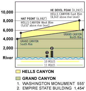
Hells Canyon, North America's deepest river gorge, encompasses a vast and remote region with dramatic changes in elevation, terrain, climate and vegetation. Carved by the great Snake River, Hells Canyon plunges more than a mile below Oregon's west rim, and 8,000 feet below snowcapped He Devil Peak of Idaho's Seven Devils Mountains. There are no roads across Hells Canyon's 10-mile wide expanse, and only three roads that lead to the Snake River between Hells Canyon Dam and the Oregon-Washington boundary.
Where is Hells Canyon?
There is no recognized geographic place called Hells Canyon. According to R.G. Bailey’s book, Hells Canyon, the canyon starts 90 miles south of Lewiston, Idaho and Extends 40 miles further south to appoint near Oxbow, Oregon. This is, of course, debatable.
How did it get its name?
According to Carrey, Conley, and Barton, in their book Snake River of Hells Canyon, most of the early explorers referred to the gorge as Box Canyon or Snake River Canyon. The first reference to Hells Canyon appears in an 1895 edition of McCurdy's Marine History of the Pacific Northwest. In discussing the voyage of the steamboat, Norma, the author writes; “she then bound off, swinging into midstream, and like a racehorse, shot into Hells Canyon…” The name was used by the Mazama hiking club in their 1931 bulletin. Bailey’s book, Hells Canyon, was published in 1943. Senator Neuberger of Oregon used it in several publications in the 1930s.
How deep is the canyon?
He Devil Mountain is 9,393 feet above sea level. The canyon plunges 7,913 feet, and 1 ½ miles from its summit to the mouth of Granite Creek, 6 miles away, at 1,480 feet.
How long have people lived in Hells Canyon?
The earliest firm date comes from a rock shelter at Bernard Creek, 7,100 years ago. A Clovis point found near the south end of the canyon indicates the possibility of human occupation 15,000 years ago. These people left ample evidence of their passing including some magnificent rock art at places like Buffalo Eddy. Figures carved into the rock are called petroglyphs, and pictures painted on the rock are called pictographs. They are not a form of written language; their meanings are lost in time.
Distance along the canyon
Starting at Hells Gate State Park, it is:
- 3 miles to Asotin
- 17 miles to Buffalo Eddy
- 26 miles to Grande Ronde River
- 33 miles to the Hells Canyon National Recreation Area northern boundary and the Oregon State line
- 45 miles to Imnaha River
- 53 miles to Dug Bar
- 72 miles to Pittsburg Landing
- 77 miles to Kirkwood Historic Ranch
- 86 miles to the Sheep Creek Ranch
- 88 miles to Rush Creek Rapids
- 104 miles to Hells Canyon Dam
How was Hells Canyon formed?
Most of the older rocks we see in the canyon came from underwater volcanoes when Hells Canyon's terrain glued themselves to North America about 150 million years ago as a result of tectonic plate movement. Vast areas were later covered with successive lava flows, as recently as 6 million years ago. Uplifting from deep in the earth's core formed the Seven Devils and Eagle Cap Mountains, a process that continues today. The canyon itself is a result of both uplifting and erosion. There have been recent basalt flows and you will also see limestone formed on the ocean floor, ancient lavas, alluvial deposits, and the remains of primitive swamps that grew on the island surfaces.
What is a National Recreation Area?
A national recreation area is a special area designated by Congress for use and enjoyment by the public for recreation, with certain objectives. The 652,488 acre Hells Canyon National Recreation Area is managed by the USDA Forest Service, Wallowa-Whitman National Forest.
The Wild and Scenic Snake River
How long is the Snake River?
The Snake River originates in Yellowstone National Park at 9,500 feet and winds through southern Idaho before turning north to form the boundary between Idaho and Oregon. It finally joins the Columbia River near Pasco, Washington at 340 feet in elevation 1036 miles from its source. According to Bill Gulick, in his book Snake River Country, the Snake drains 109,000 square miles and contributes 36 million acre feet of water to the Columbia River, ranking 6th in volume among the nation's rivers.
How did the river gets its name?
Indians living along the river in southern Idaho used a hand sign to identify themselves that resembled the movement of a snake. Although, it didn't mean ''snake', that name was given to this group of people, now known as the Shoshone. The river flowing through the Snake Indian's land was given the tribal name.
How deep is the river?
It varies from two to three feet, and in some areas it runs 105 feet deep, near Cache and Deep Creeks.
How much does the river drop?
The average fall per mile from Hells Canyon Dam to the Oregon state line is 8.7 feet.
How much of the river is Designated Wilderness?
The half mile wide designated river corridor is adjacent to the 213,906 acre Hells Canyon Wilderness over much of its length, but none of the corridor is wilderness.
Is the Snake River Protected Under the Wild and Scenic Rivers Act?
The 31.5 miles of river from Hells Canyon Dam to Upper Pittsburg Landing is designated "wild". The next 36 miles of river is "scenic from below Upper Pittsburg Landing to a point above Cache Creek Ranch. The balance of the river is designated "study river" to the Oregon-Washington border.