
Official websites use .gov
A .gov
website belongs to an official government organization in the
United States.
Secure .gov websites use HTTPS
A lock
(
) or https:// means you've safely
connected to the .gov website. Share sensitive information only
on official, secure websites.


Fossil Creek
Recreation Information
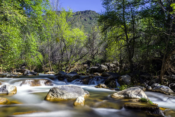
Fossil Creek, one of two "Wild and Scenic" rivers in Arizona, seems to appear out of nowhere, gushing 20,000 gallons a minute out of a series of springs at the bottom of a 1,600 foot deep canyon. Over the years these calcium laden waters have laid down huge deposits of a type of limestone called travertine. That rock-like substance encases whatever happens to fall into the streambed, forming the fossils for which the area is named.
Most people come to Fossil Creek to sunbathe, wade, hike and birdwatch. It's also a great place to take photographs. The lushness of the riparian area strikes a sharp contrast to the brittle desert that surrounds it. While you're here, keep an eye out for javelina. These collie dog-sized wild pigs are plentiful in the area.
More information can be found through the Coconino National Forest.
Fossil Creek Comprehensive River Management Plan (CRMP)
Congress designated Fossil Creek as a Wild and Scenic River in spring 2009 to protect this river’s amazing attributes for years to come. This designation included approximately 16.8 miles from the confluence of Sand Rock and Calf Pen Canyons to the confluence with the Verde River. 9.3 miles were designated as Wild and 7.5 miles were designated Recreational under the Wild & Scenic Rivers Act.
A long-awaited plan as to how Fossil Creek will be managed and protected was released on October 4, 2021, despite the current Fossil Creek closure and June Backbone Fire damage.
The signatures of both Laura Jo West, Coconino National Forest Supervisor, and Neil Bosworth, Tonto National Forest Supervisor, allow for the implementation of the Fossil Creek Comprehensive River Management Plan (CRMP).
In addition to the CRMP, an Environmental Impact Statement (EIS), Record of Decision (ROD) and Supplemental Information Report – detailing the documented effects of the Backbone Fire in the Fossil Creek area – have been released.
This plan will allow for several projects in the Fossil Creek area, including road repair, visitor-use management and streambank stabilization.
After 12 years of collaboration, the CRMP was finalized and ready for signature in June 2021. However, the Backbone Fire – which burned through the entire Wild and Scenic River corridor – delayed the process.
Due to low amounts of high-severity burn effects and a mosaic of no, low and moderately-burned areas, the Fossil Creek area is expected to recover from the Backbone Fire in only a few years.
The complete Fossil Creek management plan provides flexibility to respond to changing management needs and patterns of use in the area. It includes plans for:
- Public safety
- Forest Road 708 repair
- Protection and enhancement of natural and cultural values
- Site improvements for quality recreation experiences
- Effective visitor-use management through continuance of the current permit system
- Monitoring and adaptive management
The finalized plan authorizes expanded opportunities for visitors to experience Fossil Creek by increasing user capacity and designating improvements to various recreation sites over time.
While much of the Fossil Creek corridor will remain closed into 2022 due to the Backbone Fire, eventual implementation of the CRMP could allow for increased visitor numbers if certain criteria outlined in the plan are met.
Adaptive management framework and ongoing involvement and monitoring by both the Coconino and Tonto national forests – as well as partner agencies – is at the heart of both the decision and full management plan.
For more information on the Fossil Creek CRMP and Record of Decision, visit the Coconino National Forest website.
Alerts & Warnings
- EVACUATIONS: 136th Street to 144th Street to Dove Valley Rd to Tonto Boundary
- NEVER Bring or Use Fireworks on Federal Lands. It is Illegal.
- 03-12-01-24-29 Riverside Fire Closure Order
- 03-12-03-24-26 Adams Fire Emergency Closure Revision
- 03-12-06-24-27 Tonto Creek Crossing Road Closures
- 03-12-00-24-24 Emergency Stage 1 Fire Restrictions Entire Forest
- 03-12-01-22-26 Rattlesnake Cove Recreation Fishing Dock Closure
- 03-12-01-24-28 Wildcat Safety Recovery Closure Order
- Amended - Apache Lake Closure - Lower Burnt Corral Campground remains closed
- Bald Eagle Seasonal Closures
- Occupancy and Use Restrictions
- Update on State Route 88 (Apache Trail) - August 18, 2021
- Redmond Fire Road Closure