
Official websites use .gov
A .gov
website belongs to an official government organization in the
United States.
Secure .gov websites use HTTPS
A lock
(
) or https:// means you've safely
connected to the .gov website. Share sensitive information only
on official, secure websites.


Glaciers
Tidal currents between Hubbard Glacier and Gilbert Point
Continental ice sheets shaped the landscape of Southeastern Alaska over millions of years. The slow-moving ice carved deep fiords, sharpened mountain summits, and transported tons of sediment and debris onto the landscape. Large-scale deglaciation ended approximately 14,000 years ago and a barren landscape was left in its wake. The land once under ice became flooded with sea water within the steep valleys and trenches left after the last major ice retreat, eventually creating the Alexander Archipelago. Coastlines shifted due to more tectonic events, sea level changes worldwide, and isostatic rebound.
From this relatively bare and rugged landscape littered with glacial rubble and sediments, grew forested and non-forested habitats over thousands of years, evolving into the plant communities we see today. Depending on the substrate lichens, moss and fungi are usually the first to appear, followed by grasses, flowering plants, willows, alders, and conifer. Conifer forests generally formed on slopes that provide better soil drainage. Peatlands (muskegs) developed in more gently flat terrain where water accumulated and decomposition rates were suppressed. Plants and animals (including salmon) recolonized into the region at various rates and from different places of origin, often independently of one another.
The present - day glaciers are fed from the moisture-laden Japanese current abruptly encountering the Coast Range and delivering high amounts of precipitation to the landscape. These glaciers in turn contribute massive amounts of freshwater to multiple glacial watersheds, which currently contribute approximately 30% of total freshwater discharge from Southeast Alaska. The glaciers we see today are not considered stagnant features. Many are still receding and losing mass balance at varying rates. Some retreating glaciers are exposing new land on an annual basis, providing opportunities for research on plant succession, hydrologic processes, or gaining new recreation opportunities and enhancing wildlife habitat. Glacier change can also be used as barometers of warming effects and all are vulnerable to accelerated regional and global climate change. Multiple species of plants, birds and other animals use glacial habitats as home or feeding areas.
The history and diversity of glaciers on the Tongass are many, and so are the methods to experience them. Outfitter and guide services in local communities offer opportunities to explore glaciers by cruise ship, small boat, float plane, foot, kayak, skis, helicopter and even dogsled!
Glaciers on the Tongass
The massive Yakutat, Juneau, Stikine and Chickamin Ice Fields stretch across the crest of the Coast Mountains and the St Elias Range from Yakutat Bay to Misty Fiords. The rivers of ice they spawn are of interest to both scientists and visitors alike, and the Tongass National Forest offers many opportunities to get fairly close and personal with a glacier.
Many of Tongass glaciers empty into a glacial lake or a silty river flowing from under the ice that eventually reaches the sea. The large mainland rivers of the Tongass such as the Alsek, Taku, Stikine and Chickamin are fed by glaciers and adjacent icefields. Some of these glaciers require more planning to reach, as changing tides, boating long distances from communities and floating icebergs will slow you down, but it’s worth the effort! Ice breaking off from glaciers and crashing into the sea is called calving. Glaciers that calve directly into the sea are known as tidewater glaciers.
A boat ride from Wrangell or Petersburg can bring you close to the ice of LeConte Glacier, the southernmost tidewater glacier on the continent. LeConte Glacier and LeConte Bay reside in the Stikine-LeConte Wilderness. This glacier produces multiple calving events with numerous icebergs clogging the bay. These floating ice giants play host to harbor seals, especially during the pupping season in May and June. Petersburg High School students are monitoring glacier movement and thickness at the terminus, while university researchers are studying the interactions between the ocean and the glacier.
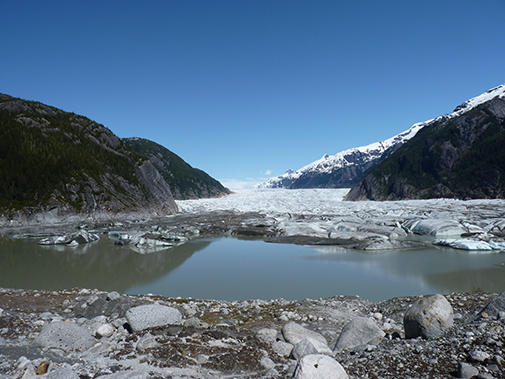
One glacier river that flows into a lake and eventually a river is the Mendenhall Glacier. It is the most accessible glacier to visit on the Tongass. It is located 13 miles from downtown Juneau along a paved road. The Mendenhall Glacier Visitor Center offers spectacular views of the glacier, floating icebergs, and the fantastic Juneau Icefield feeding it. There are additional trails in the Juneau area that lead to scenic views of Mendenhall and other glaciers.
 Baird Glacier is approximately 20 miles NE from the town of Petersburg. In the past, it received a flow of visitors in spring because the glacier was resting on the terminal moraine, which is accessible by boat and hiking. Mountain climbers planning to ascend the infamous Devil’s Thumb would use this icy route to reach the base of the Thumb. Due to a large glacial lake outburst flood in 2015 (called a jökulhlaup) the terminus broke apart and retreated almost ½ mile, presently ending at the edge of a shallow lake, and no longer accessible by hiking from the moraine. However, this glacier has an outwash plain and terminal moraine still accessible by boat, and serves as the summer nesting and/or feeding grounds to many seabirds, including the Arctic Tern. Take a virtual trip to the Baird Glacier here.
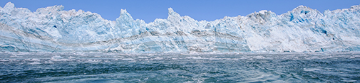
 Hubbard Glacier is located near Yakutat, Alaska and is the largest tidewater glacier in North America. In a region of retreating glacier, Hubbard Glacier's annual advances compared to those rapidly retreating makes it of great interest. the highest source of snow accumulation is at approximately 11,000 feet, traveling 76-miles towards the 6-mile wide terminus at sea level in Disenchantment Bay and Russel Fiord. The terminus reaches as height as 328-feet above sea level, equivalent to the height of a 30-story building.

Patterson Glacier near Petersburg, Alaska has receded so much in the last 20 years, the lake is now accessible via floatplane. the area near the glacier once supported an older forest that was wiped out during the Little Ice Age roughly 200 years ago. Remnants of this ancient forest remain in the area.
 Shakes Glacier is in the Stikine LeConte Wilderness near the town of Wrangell. The glacier once reached the Stikine River in the late 1600’s and has been receding ever since, with a more rapid retreat since 1995. It can be visited via boat on the Stikine River to Shakes Lake. Wrangell High School students are studying this glacier.