
Official websites use .gov
A .gov
website belongs to an official government organization in the
United States.
Secure .gov websites use HTTPS
A lock
(
) or https:// means you've safely
connected to the .gov website. Share sensitive information only
on official, secure websites.


American River Ranger District Trails Program
Off-Highway Riding, Wilderness Wandering, and Big Tree Strolling
The American River Ranger District offers something for every type of trail enthusiast. Whether you enjoy exploring routes on foot, on hooves, or on wheels, the American River Ranger District (ARRD) Trail Crew works hard throughout the year to maintain and create opportunities here for you. Below is a glimpse of the diverse options on the district:
Off-Highway Riding
The Foresthill Off Highway Vehicle (OHV) area offers over one hundred miles of trails for both motorcycles and ATVs less than 50 inches in overall width. Most of the trails can be accessed from the Parker Flat and Sugar Pine Staging Areas. These entry points are well suited for families and riders new to the trail system. The China Wall Staging Area provides access for loops 5 and 6, which are the most difficult routes in the system and are for motorcycles only. During winter, China Wall is a good place for snowmobile staging, ARRD Trail crew grooms snowmobile trails along the Foresthill Divide during the winter to provide access to higher country.
Expansion in Progress: China Wall to Robinson Flat Connecter Project
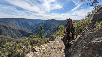
Annual trail clearing, view from Loop 6
Through a 3-year OHV “green sticker” grant from the California Off-Highway Motor Vehicle Recreation (OHMVR) Division, and partnership with the Nevada County Woods Riders, the ARRD Trail Crew is actively building a 24-mile, multi-use, motorized single track trail that will connect high and low elevations trails. Multiple uses will include motorcyclists, mountain bikers, hikers, and equestrians.
This new trail will connect Robinson Flat Campground to Loop 5 near humbug plateau which is accessed most easily from China Wall OHV Staging Area. This will provide advanced, highly skilled riders an opportunity to challenge their skills and abilities at 5,000 to 7,000 feet in elevation.
Trail construction is underway with an estimated completion date of 12/31/2023. It includes bridge installation, hazard tree felling, brush removal with chainsaws and hand tools; the use of small trail dozers and mini-excavators to build the trail; and blasting to carve through bedrock.
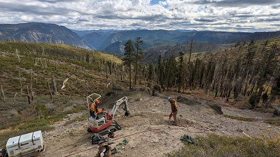
Trail crew using mechanized equipment to build the Robinson Flat to China Wall Connector Trail.
Wilderness Wandering
For long-distance hikers, trail runners, and equestrians the Tevis Cup Trail and Western States Trail provides entry to the Granite Chief Wilderness. This federally designated wilderness area contains over 25,000 acres of diverse terrain, including stunning valley meadows and 9000-foot granite peaks. The Tevis Cup Trail is also used by the Western States Endurance Run and the Western States Endurance Ride (separate 100 mile run and equestrian events). Event usage pre-dates Granite Chief Wilderness designation.
Enhancement on the Horizon- Granite Chief Wilderness Trail Reroute Project
Portions of the current Tevis Cup Trail have overly steep trail grades that have become rutted from poor alignment and erosion. Multiple sections of the trail intersect stream course channels where accelerated erosion is occurring, posing user safety and resource damage concerns. Maintenance work was completed in partnership with Western States Endurance Run Foundation and Western States Trail Foundation in 2016 to maintain these sections but a realignment of the trail will greatly reduce trail maintenance efforts and benefit wilderness resource, With $800,000 from the Great American Outdoors Act and partnership with the Western States Endurance Run Foundation (organizers of the Western States Endurance Run), the Western States Trail Foundation (organizers of the Tevis Cup Ride), the Pacific Southwest Region Pack Stock Center of Excellence, and Palisades Tahoe, the district will begin work on the Granite Chief Wilderness Reroute project in 2023.
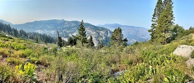
Southward view from future new segment
This project will realign over five miles of the Tevis Cup Trail along the ridge connecting Granite Chief, Needle and Lyon Peaks, affording access to new stunning vistas. When completed, the new trail system will provide hikers, runners, and equestrian users a less steep trail, with opportunities to explore additional shorter loops on the Tevis Cup Trail and Talbot Creek Trail on both the east and northwest side of Granite Chief Wilderness.
To complete this project, a 20-person trail crew will live and work in a remote wilderness setting for a total of 14-16 weeks. This rewarding hard work will be a unique opportunity to reside temporarily in the backcountry while contributing directly to a legacy that will benefit both the public and sensitive natural resources. Interested in taking part? Contact the Tahoe National Forest.
Big Tree Stroll
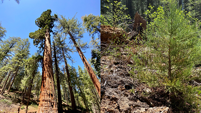
Happily, this grove is showing signs of natural regeneration
Want to be awestruck? The Big Trees Nature Trail invites hikers to look up at giant sequoias (Sequoiadendron giganteum) – the most massive (by volume) trees on earth. These endangered trees are endemic to California, meaning they grow naturally only here, and nowhere else in the world. The grove within the American River Ranger District is extra exceptional for the mystery it contains: it is both the northern most grove of this special species, and also the most distant from all the other groves in the state. Visitors can explore these botanical wonders of the world along a short loop, under 1 mile in total length, which has been designated as a National Recreation Trail.
Next Generation Growth Occurring