
Official websites use .gov
A .gov
website belongs to an official government organization in the
United States.
Secure .gov websites use HTTPS
A lock
(
) or https:// means you've safely
connected to the .gov website. Share sensitive information only
on official, secure websites.


U.S. Forest Service Beaver Planes and Pilots Support Forest Missions
History Provides Present Day Benefits
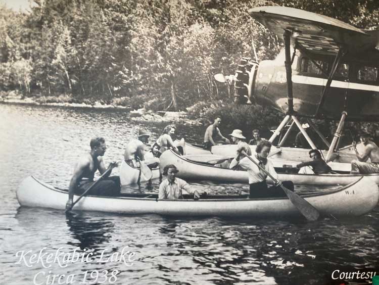
Predating even the iconic Smokey Bear, the long and rich history of the U.S. Forest Service (USFS) Beaver Program began in 1929. Based at the Superior National Forest Seaplane Base in Ely, Minnesota, local seaplane pilots began flying fire detection flights and hauling fire crews for the Forest Service in 1929. In 1935, the first contract was issued for seaplane usage and in 1938 the Forest Service acquired its first dedicated aircraft to support the Superior, a four-seat Stinson SR6A floatplane. Since then the program has been in continuous operation providing support for a wild variety of missions including wildland fire, search and rescue, wildlife surveys, fish stocking, aerial seeding and pest detection flights.
Although short on roads and runways, the 3-million-acre Superior National Forest which includes the 1-million-acre Boundary Waters Canoe Area Wilderness (BWCAW), is long on water and ice. The Beaver’s impressive load-hauling capabilities, short takeoff and landing performance, and reliability make it the perfect aircraft for operating in these conditions. Although the entire wilderness prohibits aircraft from low level flying (below 4,000 feet) the USFS Beavers can receive special permission from the Superior Forest Supervisor to fly missions inside the prohibited areas including takeoff and landing.
Wildland Fire Support
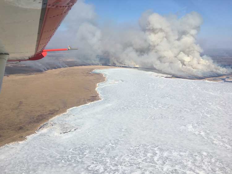
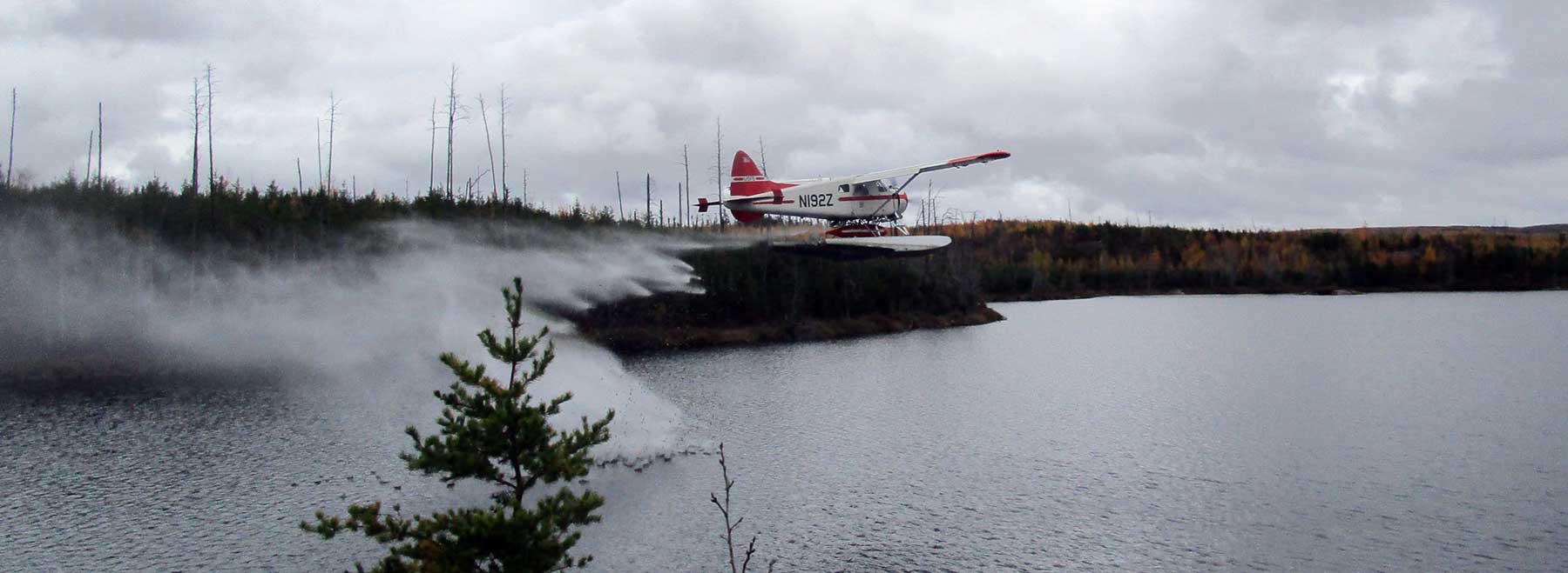
During fire season, generally from April through October, pilots focus on wildland fire support. Beavers support prescribed burns by observing smoke dispersion, burn progression and the potential threat for the fire to compromise planned boundaries. When wildland fire indices reach certain levels, routine patrols are flown over the Chippewa and Superior National Forests. Beavers can provide a fire size-up: a detailed report on incident location, size, characteristics, spread potential and threatened structures. For fires in locations accessible by ground forces, pilots direct firefighters on the quickest approach and report winds and progression. For remote fires, or any fire threatening structures or with limited water sources, ground forces or dispatch direct the Beaver to conduct initial attack via scooping and dropping water with the water bombing tank. Depending on the proximity of the water source, the pilot can drop water on the fire every three to four minutes.
When fires become too large for the Beaver to effectively drop water, firefighter crews and gear (including a canoe strapped to the float) are flown to the incident. Sandy beaches ideal for landings are not common in the BWCAW, so most often the pilot shuts down in the middle of the lake and drifts while unloading the crew and their gear into the canoe to paddle the rest of the way. Crews commonly paddle home after extinguishing a fire, but the Beavers can also fly crews out and the planes remain on standby while firefighters are in the field to provide emergency transport if necessary.
Superior National Forest Mission Support
 Year-round aerial search and rescue, medevac, and law enforcement support is provided by the Beaver program through an agreement with the Minnesota counties of St. Louis, Lake and Cook. Most flights are within the BWCAW, as there are no roads and mechanical access is generally not permitted. During the high use summer season common scenarios involve dehydration, broken bones or sprains, axe wounds, heart attack or stroke symptoms, overdue parties or individuals, or a SPOT or InReach device being activated inadvertently. An EMT flies along for medevac situations, and a law enforcement officer for search or non-medical incidents.
Wildlife surveys also make up a good portion of the annual flying. The program has provided over 35 years of continuous support to the U.S. Geological Survey flying year-round survey flights with wildlife biologists tracking radio- and GPS-collared wolves and deer as well as conducting beaver survey flights in the fall. Forest Service surveys for bald eagles are also flown in the spring.
The Beaver program supports the Minnesota Department of Natural Resources with fish-stocking operations and surveys of remote lakes. Fish stocking involves landing in a lake, shutting down and slowly releasing the fish from the internal tank through the camera hatch. If the lake is too small to land and the fry are the correct size, aerial release is possible. For lake surveys, the planes carry two biologists along with gill nets, camping gear, outboard motor and gas, and a 19-foot canoe strapped on the float.
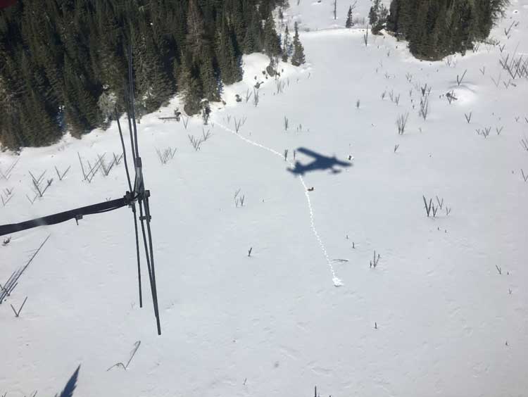
Springtime flights include installing a hopper to broadcast tree seed to restock previously harvested areas. The Beaver flies 40-foot-wide strips at approximately 80 miles per hour and 50 feet above ground level to spread the seeds, primarily spruce or jack pine. A 40-acre plot can typically be completed in just 10-15 minutes, and multiple plots with different seed types can be completed during a single flight.
Annual aerial pest detection survey flights map insect, disease and weather event disturbances on federal forestlands for forest health monitoring and to facilitate local forest management activities. These flights involve flying gridlines over the entire Superior and Chippewa National Forests as well as Isle Royal National Park off the northeast tip of Minnesota.
The future of the USFS Beaver program remains as bright as ever. Under Forest Service Eastern Region fire and aviation management, plans are underway to expand the use of these aircraft and pilots beyond northern Minnesota to better serve Forest Service aviation needs in surrounding states and potentially throughout the region.