
Official websites use .gov
A .gov
website belongs to an official government organization in the
United States.
Secure .gov websites use HTTPS
A lock
(
) or https:// means you've safely
connected to the .gov website. Share sensitive information only
on official, secure websites.


Cucamonga Wilderness
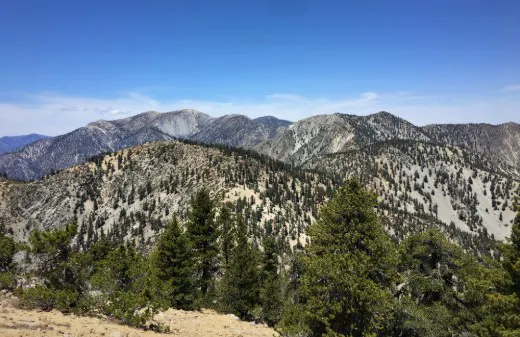

The steep, rugged terrain of the Cucamonga Wilderness rises abruptly from the urban San Bernardino Valley, ranging from approximately 5,000 feet to almost 9,000 feet. Most of the streams are intermittent and water is scarce, but the wilderness offers a handy retreat to a beautiful sub-alpine setting on 18 miles of trails for the nearby suburban and city population. Numerous wildlife species do well in the area, including deer, bears, mountain lions and bighorn sheep.
Permits
A free wilderness permit is required for day hikes and overnight trips. The requirement is only for portions of the wilderness within San Bernardino National Forest, not Angeles National Forest.
To obtain a permit, visit the permit page for the San Gorgonio Wilderness Association, a Forest Service partner. Permits can be requested up to 90 days in advance.
-
Day Use: Permits are available to enter the wilderness in San Bernardino National Forest from four locations.
-
Middle Fork Trail off Middle Fork Road (2N58) by way of Lytle Creek (Note: An Adventure Pass is required for parking at the trailhead).
-
Cucamonga Peak - Ice House Saddle Trail off Big Trees Cucamonga Road (1N34) by way of Lytle Creek (Note: This road is closed annually between September 1 and March 1).
-
Ice House Saddle from the Ice House Canyon Trail on the Angeles National Forest
-
A permit is only required for entering the wilderness within San Bernardino National Forest. Visitors need a permit when going beyond Ice House Saddle to Cucamonga Peak, Etiwanda Peak and other interior areas. A permit is not needed for Ontario Peak via the Ontario Peak Trail.
-
-
Ice House Saddle from the Three T's Trail on the Angeles National Forest.
-
Please see the note for
Ice House Saddle from Ice House Canyon Trail
above.
-
-
-
Camping: Permits are required for camping. There are three campsites located off the Middle Fork Trail.
-
Commanche, located approximately 1.5 miles downhill from Ice House Saddle.
-
Third Stream Crossing, located approximately 2 miles downhill from Ice House Saddle.
-
Stone House Crossing, located just outside the wilderness boundary one mile from the Middle Fork Trailhead.
-
Other Regulations
-
No campfires allowed at any time.
- Gas stoves are allowed with a free California Campfire Permit.
-
No possessing or using a hang glider or bicycle.
-
Group size limited to 12 people maximum.
-
Possessing or using a motor vehicle, motorboat or motorized equipment except as authorized by Federal Law or regulation.
Safety
Keep yourself safe on the trails while protecting your vehicle and valuables back at the trailhead with the following tips:
- General Hiking Tips: Trails in the Cucamonga Wilderness are recommended for the intermediate to expert hiker. Elevations range from 3,983 ft. at the Middle Fork Trailhead to 8,985 ft. at Telegraph Peak. Please review the Forest Service's hiking safety tips before heading out on your trip.
- Winter Hiking: Dangerous conditions exist when snow and ice conditions are present. This is especially dangerous as many trails in the wilderness are exposed to steep terrain. Visitors should take extreme caution and only go with proper gear (e.g. traction devices, ice axe, etc.) and experience/training using that gear.
- Protect Your Vehicle: You'll be away from your vehicle for a few hours to a few days. Help protect your vehicle and valuables by reading the
Protect Your Car
section on the Forest Service's crime prevention webpage.
About the Wilderness
The United States Congress designated the Cucamonga Wilderness in 1964. The wilderness has a total of 12,781 acres and managed jointly by the Angeles and San Bernardino national forests.
The name Cucamonga
was derived from an old nearby Spanish rancheria. The meaning has been variously interpreted as sandy place
or place of many springs.
That may describe the rancheria, but not the Cucamonga Wilderness, located at the east end of Southern California's San Gabriel range.