
Official websites use .gov
A .gov
website belongs to an official government organization in the
United States.
Secure .gov websites use HTTPS
A lock
(
) or https:// means you've safely
connected to the .gov website. Share sensitive information only
on official, secure websites.


Eastern Region App for iOS and Android
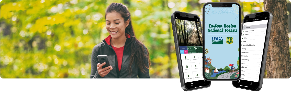
Download. Discover. Disconnect.
The Eastern Region Forest Service App is free and now available to help guide Forest visitors for their next adventure.
Visitors to Eastern Region National Forests and Tallgrass Prairie can quickly access essential information about their visit. Discover the perfect hike, bike or fishing spot or easily choose a campground experience. Quick access to forest facts, natural, cultural and historic information; offline and GPS maps; fire closures, and safety updates are now available on the go.
Download the App


Features of the Eastern Region National Forests App
 Get Precise
Discover nearby recreation destinations within 50 miles of your current location by using the "Near Me" and find nearby new adventures.
 Stay Up-to-Date
Up-to-date news and closure information for all Forests and Tallgrass Prairie allow you the confidence of latest safety and closure alerts.
 20 States with 18 National Forest and Grasslands
Afternoon getaway or week-long road trip? Plan adventures from Minnesota to Maine, down to Missourri and back to West Virginia.
Getting Started with the Eastern Region National Forests App
Look for Our Icon
Scan To Download Direct to Device

Android

iOS
No Service, No Problem
Official Forest and Tallgrass Prairie information is cached, or saved locally to your device, once it is viewed offline to make it easy to take important visitor information with you on the go. Links to downloadable maps are available within the app, however we recommend visitors download the Forest Service Interactive Visitor Map application for the most portable digital maps in the agency.
About the Eastern Region
“This mobile app is one of many ways we are trying to do our part to be good neighbors and support both the communities we serve and the recreation users who visit,” said Gina Owens, Eastern Region, Regional Forester.
“We heard people want more mobile-friendly ways of getting their hiking, camping, and other recreation information, and this app delivers just that.”
The Eastern Region, consists of 17 national forests, 42 ranger stations, and one national tallgrass prairie. It is also home to the Forest Service’s largest State, Private, and Tribal Forestry program, collaborating with Tribes, States, communities, Federal agencies, private landowners, and other partners to protect, conserve, and manage forests and community trees across 20 States and the District of Columbia. To learn more about the USDA Forest Service in the Eastern Region, visit our website or follow us on Twitter @usfs_r9.