
Official websites use .gov
A .gov
website belongs to an official government organization in the
United States.
Secure .gov websites use HTTPS
A lock
(
) or https:// means you've safely
connected to the .gov website. Share sensitive information only
on official, secure websites.


- Flash Floods
- Other Types of Floods
- Lightning
- Hurricanes
- Tornadoes
- High Wind Hazards
- Heat Wave
- Winter Weather Hazards
- Frostbite
- Hypothermia
- Hail
Flash Floods
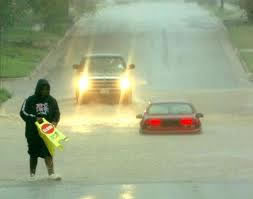
A flash flood is a rapid rise of water in a low-lying area, usually caused by an intense storm that produces heavy rainfall in a short amount of time. It develops rapidly and can strike with little or no warning. Flash floods can occur between hills, near small streams or in any low area. Small streams can become raging rivers with the strength to roll boulders and vehicles, tear out trees and wash away bridges. A flash flood can unleash deadly force in minutes.
Always consult the National Weather Service forecast before visiting a national forest. Do not come when inclement weather is forecasted.
National Weather Service lingo: A flash flood watch means threatening weather is possible in the area. A flash flood warning means you may have only seconds to escape.
During a weather event, a flash flood watch or warning will be broadcast on the news and transmitted on weather radios. Also, cell phones can receive wireless emergency alerts--a personal warning about imminent threats like flash floods. Consumers can sign up to receive imminent threat alerts from their cellular carrier, or install a weather alert app on a smart phone.
Remember, flash floods develop so rapidly that you may not get a warning. Any time a warning is issued, climb to safety immediately. Do not remain in a low-lying area.
Safety Checklist (download)
- Know your area's flood risks. Monitor the NOAA weather radio all hazards bulletins, or your local news stations for vital weather information.
- Stay alert for heavy rain, thunder and lightning at your location and upstream. Watch for rising water and listen for rushing water.
- Climb to higher ground if water starts to rise. Leave low-lying areas immediately.
- Don't try to outrun a flash flood in your car. Cars can be death traps.
- Avoid areas already flooded. Do not attempt to cross a road covered with water, even a few inches. Remember: turn around; don’t drown.
- Don't try to swim to safety in a flood. Wait for rescuers.
- Be especially cautious at night, when it is harder to recognize and respond to danger. When rain is forecasted, do not camp or park your vehicle along streams, rivers, or low-lying areas.
- Consult the National Weather Service for weather updates. Carry a weather radio, a terrestrial radio or a mobile phone enabled with imminent threat alerts.
- Your safety is your responsibility. Your cellular carrier may not have coverage in remote outdoor locations.
Other Types of Floods
A flood is a high flow or overflow of water from a river or similar body of water, occurring over a period of time. Most communities in the United States can experience some kind of flooding. Floods can happen anytime during the year, such as after winter snowmelts, spring thunderstorms and fall hurricanes. The National Weather Service issues flood watches and warnings which are transmitted on NOAA weather radios and through local media.
A flood watch is issued when high water flow is possible in the specified time period. A flood warning means flood conditions are occurring, so get to safety.
Safety Checklist (download)
- Know your area's flood risks. Monitor the NOAA weather
radio all hazards bulletins, or your local news stations for
vital weather information. - Stay alert for signs of heavy rain. Watch for rising water levels.
- Get to higher ground If flooding occurs. Leave low-lying areas immediately.
- Avoid areas already flooded, especially if the water if flowing fast. Do not attempt to cross flowing streams. Remember: “Turn around - don’t drown”.
- If your car stalls, abandon it immediately and climb to higher ground. For safe driving tips, visit the Weather Channel.
- Don't try to swim to safety; wait for rescuers to come to you.
- Stay away from downed power lines and electrical wires.
- Do not let children play near flooded streams or rivers. Flooded streams and rivers are not safe for recreational boating.
- Visit NOAA for weather updates.
Lightning
Lightning can be very dangerous. It can span 5 miles in length, attain a temperature of approximately 50,000 degrees Fahrenheit and contain over 100 million electrical volts.
When lightning is possible in your area, there are two key alerts to watch for:
A severe thunderstorm watch is issued when conditions are conducive to the development of severe thunderstorms.
A severe thunderstorm warning is issued when a severe thunderstorm has actually been observed by spotters or indicated on radar, and is occurring or imminent in the warning area.
Safety Checklist (download)
- Immediately move to safe shelter when you hear thunder, as lightening is then close enough to strike you. . Safe shelter is a substantial building or inside a closed metal topped vehicle. Stay in safe shelter until at least 30 minutes after you hear the last clap of thunder.
- Stay low when outdoors: lightening hits the tallest object around, so….immediately get off elevated areas such as hills, mountain ridges, or peaks. If caught in an open field, seek a low spot and crouch with your feet together and head low.
- Avoid isolated trees, cliffs and rocky overhangs: It is better to run into a forested area if possible. Caves are a last resort for shelter, as they have high risks as well.
- Stay away from objects that conduct electricity such as barbed wire fences, power lines, windmills, and other tall objects).
- Drop metal objects like golf clubs, fishing poles, umbrellas, and backpacks with metal frames.
- Get off bicycles, motorcycles, horses, and ATV’s they can attract lightning.
- Get off lakes, ponds, and rivers and seek shelter when a storm is approaching. If you can’t get off the water, crouch down low in the boat.
- Avoid pitching your tent under the tallest tree as storms can develop during the night.
- Carry a NOAA radio or Visit www.noaa.gov for weather updates.
Hurricanes
Hurricanes are currently directly impacting national forests across the southern United States. Many of the region's campgrounds have closed due to flooding. Please call ahead or check websites to determine what is open. All fees have been waived.
With winds of 74 mph or more, hurricanes are seasonal storms that develop over a large body of warm water. When reaching a land mass, they typically bring torrential rains, high waves, a storm surge, damaging winds and devastation. Lightning and tornadoes are also possible.
According to the National Hurricane Center; on average, 11 tropical storms develop each year over the Atlantic Ocean, Gulf of Mexico or Caribbean Sea, five of which will strike the U.S. coastline, killing 50-100 people. Although a hurricane’s intensity, speed and direction is unpredictable, it can be easily tracked by weather experts, allowing travelers and forest visitors to be prepared in advanced, by monitoring hurricane weather alerts and warnings.
***Please be mindful and stay safe during a hurricane.
Safety Checklist (download)
- Modify travel plans and avoid visiting an area that is predicted to be in the path of an approaching hurricane.
- Always notify family or an emergency contact about your travel location before visiting a forest.
- Get to a safe, indoor location before a tropical storm or hurricane approaches your area.
- Turn around if you are in a vehicle and see flooding ahead of you. Don't underestimate the force and power of water. A vehicle can be swept away in just 12 inches of water.
- Have a hurricane preparedness kit, especially if you live and travel in hurricane-prone areas.
- Visit www.noaa.gov for weather updates and detailed information about hurricane preparedness.
Hurricane Watches and Warnings
When a hurricane or tropical storm is possible in your area, there are four key alerts to look for:
A tropical storm watch is issued when tropical storm conditions with sustained winds from 39 to 73 mph are possible in your area within the next 48 hours.
Tropical storm warnings are issued when tropical storm conditions are expected in your area in the next 36 hours.
A hurricane watch is issued when hurricane conditions (sustained winds of 74 mph or greater) are possible in your area in the next 48 hours.
Hurricane warnings are issued when hurricane conditions are expected in your area in 36 hours or less.
Please stay informed and take precautions to stay safe if a hurricane is expected in your area.
Tornadoes
A tornado is a violently rotating column of air extending from the base of a thunderstorm down to the ground. Tornado intensities are classified as F0 (weakest) to F5 (strongest). They are capable of completely destroying well-made structures, uprooting trees and hurling objects through the air.
A tornado watch is broadcast when conditions are conducive to the development of tornadoes. A tornado warning is issued when a tornado has been sighted, indicated on radar, or is occurring in the warning area.
Safety Checklist (Download)
The biggest danger you'll face if a tornado strikes while you're in the forest is falling trees and tree limbs.
If outdoors:
- Get inside a building if possible. At a developed campground, the restroom may be the closest option.
- If shelter is not available or there is no time to get indoors, lie in a ditch or low-lying area or crouch near a strong building.
If in a car:
- Never try to outdrive a tornado in a car or truck. Tornadoes can change direction quickly and can lift up a car or truck and toss it through the air. Get out of the car immediately and take shelter in a nearby building.
- If there is no time to reach shelter, get out of the car and lie in a ditch or low-lying area away from the vehicle.
High Wind Hazards
A microburst is a localized column of sinking air that produces damaging winds near the ground. The high winds of a microburst can knock over fully grown trees. The wind burst will typically last a few seconds. There are two types of microbursts: wet microbursts and dry microbursts. Pay attention to high wind advisories and high wind warnings issued by the National Weather Service.
Safety Checklist (download)
- Take shelter immediately if there are high winds in the area you are visiting.
- Watch out for falling trees and limbs, and flying debris.
- Be careful when driving. Strong winds can making driving difficult, especially high profile vehicles (RVs, campers and trucks). Be careful on bridges and overpasses.
- Tune in to local weather forecasts and bulletins issued by the National Weather Service. Visit NOAA for weather updates. Visit The Weather Channel for safe driving tips.
Heat Wave
A heat wave is a prolonged period of excessively hot weather that can be hazardous to your health. Sometimes it involves the combination of heat and humidity, which causes the air to become oppressive and stifling. Heat waves are relative to the normal climate in a particular location. There is no universal definition of heat wave; it is not linked to an exact temperature. Heat waves can cause officials to issue weather alerts for personal safety. A heat advisory is issued when high temperatures, or the combination of heat and humidity, are expected to become an inconvenience for much of the population and a problem for sensitive individuals.
A heat warning is issued when the weather conditions are expected to be dangerous for a large portion of the population.
Safety Checklist (download)
- Listen to a NOAA weather radio for heat advisories and warnings. Check the UV index on weather sites.
- Stay hydrated. Drink plenty of fluids. Avoid caffeine and alcohol. Eat small frequent meals.
- Wear approrpriate clothing that are loose-fitting, light-weight, and light-colored. Avoid dark colors if trying to stay cool.
- Ensure that your animals’ needs for water and shade are met.
- Know how to recognize and treat heat-related emergencies.
- Be familiar with the terms heat stroke, heat exhaustion, heat stress and heat cramps.
- Visit http://preview.weather.com/ready/heat/risk.html and www.noaa.gov.
Winter Weather Hazards
From blizzards and snow showers to freezing rain and sleet, the weather impact that winter storms bring can be both beautiful and deadly. Winter storms also can be deceiving. Even a small amount of precipitation can cause problems, especially in areas where snow is an unusual occurrence. Many fatalities from car accidents occur as a result of slippery roads. Downed trees and power outages can also be caused by ice storms or by heavy wet snow.
Safety Checklist (download)
Although many roads will have clear sections exposed to sunlight, all National Forest roads will have icy sections due to shading and these surface conditions change with no warning. Motorists must use common sense on all roads and try to avoid unnecessary travel when the weather causes treacherous driving conditions.
- Vehicle should be in good working order and has appropriate tires for snow and mud, a jack, and plenty of fuel.
- Do not travel alone and make sure someone knows your travel plans.
- Carry an emergency road kit that supplies a map of the area, flashlight, tools, water, food, warm layered clothing and matches or other means for starting a fire.
- Travel the appropriate speed. Many forest roads are narrow, soallow for on-coming traffic, and travel with headlights on. Snow and ice covering a road can disguise surface conditions and location of the shoulder. Many of these roads are not cleared of snow or ice. In addition, ice storms or very heavy snows can cause tree limbs to snap and fall across roads and trails.
Frostbite
Frostbite is an injury to the body that is caused by freezing of the skin and tissue.
Frostbite causes a loss of feeling and color in affected areas. It most often affects the nose, ears, cheeks, chin, fingers, or toes. Frostbite can permanently damage the body, and severe cases can lead to amputation.
The risk of frostbite is increased in people with reduced blood circulation and among people who are not dressed properly for extremely cold temperatures.
At the first signs of redness or pain in any skin area, get out of the cold or protect any exposed skin as this is an indicator of frostbite.
A victim is often unaware of frostbite until someone else points it out because the frozen tissues are numb.
Safety Checklist (download)
Any of the following signs may indicate frostbite: a white or grayish-yellow skin area, skin that feels unusually firm or waxy numbness.
If (1) there is frostbite but no sign of hypothermia and (2) immediate medical care is not available, proceed as follows:
- Get into a warm environment as soon as possible.
- Do not walk on frostbitten feet or toes unless absolutely necessary—this increases the damage. Do not rub the frostbitten area with snow or massage it at all. This can cause more damage.
- Immerse the affected area in warm—not hot—water (the temperature should be comfortable to the touch for unaffected parts of the body).
- Warm the affected area using body heat. For example, the heat of an armpit can be used to warm frostbitten fingers.
- Don’t use a heating pad, heat lamp, or the heat of a stove, fireplace, or radiator for warming. Affected areas are numb and can be easily burned.
- Note: These procedures are not substitutes for proper medical care. Hypothermia is a medical emergency and frostbite should be evaluated by a health care provider. It is a good idea to take a first aid and emergency resuscitation (CPR) course to prepare for cold weather health problems. Knowing what to do is an important part of protecting your health and the health of others
Hypothermia
When exposed to cold temperatures, your body begins to lose heat faster than it can be produced. Prolonged exposure to cold will eventually use up your body’s stored energy. The result is hypothermia, or abnormally low body temperature.
Body temperature that is too low affects the brain, making the victim unable to think clearly or move well. This makes hypothermia particularly dangerous since a person may not know it is happening and won’t be able to do anything about it.
Hypothermia is most likely at very cold temperatures, but it can occur even at cool temperatures (above 40°F) if a person becomes chilled from rain, sweat, or submersion in cold water.
Victims of hypothermia are often (1) elderly people with inadequate food, clothing, or heating; (2) babies sleeping in cold bedrooms; (3) people who remain outdoors for long periods—the homeless, hikers, hunters, etc.; and (4) people who drink alcohol or use illicit drugs.
Safety Checklist (download)
If you notice any of these signs, take the person’s temperature. If it is below 95°, the situation is an emergency—get medical attention immediately. If medical care is not available, begin warming the person, as follows:
- Get the victim warm by moving into a warm room or shelter. If the victim has on any wet clothing, remove it. Warm the center of the body first—chest, neck, head, and groin—using an electric blanket, if available. Or use skin-to-skin contact under loose, dry layers of blankets, clothing, towels, or sheets. Warm beverages can help increase the body temperature, but do not give alcoholic beverages. Do not try to give beverages to an unconscious person. After body temperature has increased, keep the person dry and wrapped in a warm blanket, including the head and neck.
- Get medical attention as soon as possible.
- Note: A person with severe hypothermia may be unconscious and may not seem to have a pulse or to be breathing. CPR should be administered in that case. CPR should continue while the victim is being warmed, until the victim responds or medical aid becomes available. In some cases, hypothermia victims who appear to be dead can be successfully resuscitated.
Hail
Hail is precipitation in the form of a chunk of ice that can fall from a cu-mulonimbus cloud. Usually associated with multicell, supercell and cold front induced squall line thunderstorms, most hail falls from the central region of a cloud in a severe storm.
Hail begins as tiny ice pellets that collide with waterdroplets. Theoptimum freezing level for theformation of hail is from 8,000 to 10,000 feet. Thewater droplets attach themselves to the ice pellets and begin to freeze as strong updraft winds toss the pellets and droplets back up into the colder regions of the upper levels of the cloud. As the attached drop-lets freeze, the pellets become larger. Both gravity and downdraft thunderstorm winds pull the pellets back down, where they encounter more droplets that attach and freeze as the pellets are thrown to the ground.
Safety Checklist (download)
- Seek shelter immediately if you are caught outdoors. If you can’t find something to protect your entire body, at least find something to protect your head.
- Stay out of culverts and lowland areas that might fill suddenly with water.
- Trees are a last resort. It is common duringsevere storms fortrees to lose branches. Also, large isolated trees attract lightning.
- Drive cautiously if you are in an automobile. Close all windows and stay in your vehicle.