Official websites use .gov
A .gov
website belongs to an official government organization in the
United States.
Secure .gov websites use HTTPS
A lock
(
) or https:// means you've safely
connected to the .gov website. Share sensitive information only
on official, secure websites.


Points of Interest
*Visit the Recreation page for information about all recreation opportunities on the forest.
Points of Interest Vicinity Map
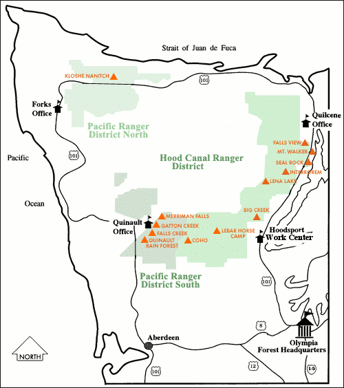 This map displays facilities, activities, and sites that you won’t want to miss while visiting Olympic National Forest.
Olympic National Forest Supervisors Office
Located just off of Highway 101 on Black Lake Boulevard, the Visitor Center is open year round. Informational brochures, maps, and numerous books are available to visitors in the interpretive sales area. The office is closed on weekends. Public restrooms are available.
High Steel Bridge
From Highway 101 north of Shelton, take the Skokomish Valley Road for 5 miles to Forest Service (FS) Road #23. Go 2.4 miles to FS Road #2340, and follow it for another 2.4 miles. The High Steel Bridge spans the South Fork of the Skokomish River at a height of 420 feet. It was originally built as a logging railroad bridge in 1929.
Hamma Hamma Area
Take Highway 101 to Forest Service Road #25, located north of Hoodsport. FS Road #25 provides a beautiful scenic drive with views of both Mount Skokomish and The Brothers Wilderness areas. Hiking opportunities include Lena Lake and other nearby trails. The Living Legacy Interpretive Trail winds up the hill from Hamma Hamma Campground, past the Old Guard Station built by the Civilian Conservation Corp (CCC). Be sure to read the interpretive signs, which describe the history of the CCC at Olympic National Forest.
Interrorem Nature Trail
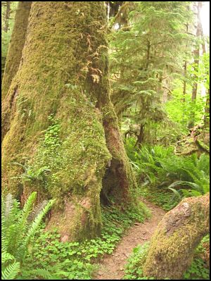
Take Highway 101 north of Hoodsport to Forest Service Road #2510, otherwise known as the Duckabush Road. Travel four miles to the historic Interrorem cabin. Casual hikers will enjoy a well maintained 1/4 mile loop Nature Trail with signs that intrepret the historic cabin, which was built in 1907. An abundance of ferns and mosses provide a lush understory of plants in the nearby stand of conifer trees. Toilet facilities are availabe at the trailhead as well as in the nearby Collins Campground. A valid Recreation Pass is required at the trailhead for day use.
Seal Rock Campground, Picnic Site and Salt Water Beach
This beautiful campground is located just north of Brinnon on Highway 101. Seal Rock is one of the few Forest Service campgrounds located next to salt water! It offers beach access for seasonal oyster and clam harvesting, nature trails, bicycling, swimming, boating, beachcombing, bird watching, picnicking and camping. Two self-guided interpretive trails describe the natural and cultural history of the area.
Mt. Walker View Point
The Mount Walker Viewpoint is located 4.1 miles off of Highway 101, between Brinnon and Quilcene. The summit of Mount Walker is 2,804 feet above sea level. From this location, visitors can enjoy panoramic views of Puget Sound and Seattle. The Mount Walker parking lot is accessible to vehicles in the spring, summer, and fall months. From the parking lot, hikers can follow a short loop trail to spectacular views. More adventuresome hikers may want to take the 2-mile trail from the bottom of the mountain to the top. The road is steep and not recommended for vehicles pulling trailers.
Quilcene Office-Hood Canal Ranger District
The Quilcene office for the Hood Canal Ranger District is located on Highway 101 in Quilcene. The visitor center offers a wide selection of informational handouts, maps, and books in the interpretive sales area. Public restrooms are available.
Mount Muller Trail
This 13-mile loop trail offers exhilarating views of Mount Olympus, Lake Crescent, and the Sol Duc Valley. Seasonal wildflowers are also spectacular at this location. Maps of the area can be obtained at the Pacific Ranger District office in Forks. A valid Recreation Pass is required for day use.
Kloshe Nanitch Lookout Site
This is the site where the historic Kloshe Nanitch Fire Lookout, built in the 1920’s, sat perched on a craggy point. The lookout no longer exists, but visitors can still enjoy spectacular views of the surrounding area, including expansive views of the Olympics and Lake Crescent. The road is steep and not recommended for vehicles pulling trailers.
Quinalt Office- Pacific Ranger District
The Quinault Office for the Pacific Ranger District is located on the South Shore Road at Lake Quinault. The visitor center offers a wide selection of informational handouts, maps, and books in the interpretive sales area. Personnel from both Olympic National Forest and Olympic National Park are available to answer questions about the surrounding area. Public restrooms are available during business hours.
Lake Quinalt and Rain Forest Nature Trail
Beautiful Lake Quinault is nestled in a temperate rain forest. Quinault is also the setting for the historic Quinault Lodge, picturesque cabins, and several campgrounds that are available to visitors on a first come, first served basis. While in the area, be sure to stroll along the popular 1/2 mile Quinault Rain Forest Interpretive Nature Trail to learn about the temperate rain forest. This trail connects with the 4-mile Quinault Loop Trail, offering a hike through the rain forest and along the lake. A Northwest Forest Pass or Interagency Pass (Annual, Senior, or Access) is required to park at trailhead. Day Passes are available at the trailhead.
See also:
- Quinault National Recreation Trail System Vicinity Map (PDF File)
- Quinault Area Hiking and Touring Vicinity Map (PDF File)
Wynoochee Lake and Dam
From Route 12 on the west side of the Olympic Peninsula, turn north on the Wynoochee Valley Road, located one mile west of Montesano. Continue 35 miles to the Wynooche Lake and Dam. This area offers opportunities for picnicking, hiking, camping, boating, fishing, and swimming. Hikers may explore the 12-mile loop trail that circles the lake, or the Working Forest Nature Trail- a short interpretive walk next to the popular Coho campground.
Points of Interest, Printable Documents (PDF)
Points of Interest |
Facilities |
Activities |
Ranger District |
|
|
None. Lookout building, deck is closed. |
Hiking, scenery |
Pacific |
|
Lena Lake |
Fire rings and compost toilet at Lena Lake |
Hiking, fishing and scenery |
Hood Canal |
|
Merriman Falls
|
None |
Scenery |
Pacific |
|
Mt. Walker Viewpoint
|
Tables and toilets |
Scenery |
Hood Canal |
|
Mountain Biking
|
Trails |
Mountain biking, scenery |
Hood Canal |
|
Mushroom Picking
|
None |
Mushroom gathering (Please see “Special Forest Products” for permit requirements) |
Hood Canal & Pacific |
|
Olympic Rain Forest
|
Nature trail, toilet, and picnic tables |
Hiking, boating and nature study |
Pacific |
|
Quinault National Recreation Trail System
|
Trails |
Hiking and scenery |
Pacific |
|
Quinault Valley Touring & Hiking
|
Camping, trails |
Hiking and scenery |
Pacific |
|
Waterfalls on the Olympic Peninsula
|
Trails, toilets and parking, available at various locations. |
Hiking and scenery |
Hood Canal & Pacific |
|
Wild Berry Picking |
None |
Berry picking |
Hood Canal & Pacific |