Auto Tours
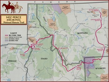
 Retrace the routes used by the Nez Perce Indians and U.S. military forces during the summer of 1877. With the cooperation of State Highway Departments and County Commissioners in the states of Oregon, Washington, Idaho, Wyoming and Montana, over 1500 miles of federal, state and county roads have been designated as the Nez Perce National Historic Trail Auto Route. The route roughly parallels the course traveled by the Nez Perce bands during their historic 1877 flight beginning near Wallowa Lake, Oregon and ending at the Bear Paw Battlefield south of Chinook, Montana. The auto route consists of three-season, all weather roadways ranging from high-standard gravel segments to portions of Interstate 15 and 90. Nez Perce National Historic Trail signs have been erected along the primary auto route and two alternate segments.
Auto Tour guides have been created for all eight segments of the Nez Perce (Nee-Me-Poo) National Historic Trail. The guides are available as pamphlets, with maps and graphics.
Experience the Nez Perce Trail
- Auto Tour Guide #1: Wallowa Valley, Oregon to Kooskia, Idaho
- Auto Tour Guide #2: Orofino, Idaho to Lolo, Montana
- Auto Tour Guide #3: Lolo, Montana to the Big Hole National Battlefield, Montana, through the Bitterroot Valley
- Auto Tour Guide #4: Big Hole, Horse Prairie and Lemhi Valleys
- Auto Tour Guide #5: Leadore and Island Park, Idaho, to Yellowstone National Park, Montana
- Auto Tour Guide #6: Through Yellowstone National Park
- Auto Tour Guide #7: Yellowstone National Park to Canyon Creek, Montana
- Auto Tour Guide #8: Canyon Creek to Bear Paw
"We, the surviving Nez Perces, want to leave our hearts, memories, and hallowed presence, as a never-ending revelation to the story of the event of 1877. This Trail will live in our hearts. We want to thank all who visit this sacred trail, that will share our innermost feelings. Because their journey makes this an important time for the present, past, and future."
~Frank B. Andrews, Nez Perce descendant
You can download copies of other publications here: https://www.fs.usda.gov/main/npnht/maps-pubs.
To order physical copies of Auto Tour Brochures, please contact:
NPNHT Administration
SM.FS.npnht@usda.gov
12740 Hwy 12
Orofino, Idaho 83544
www.fs.fed.us
www.usda.gov/npnht
p: (208) 476-8234


