
Official websites use .gov
A .gov
website belongs to an official government organization in the
United States.
Secure .gov websites use HTTPS
A lock
(
) or https:// means you've safely
connected to the .gov website. Share sensitive information only
on official, secure websites.


Mt. Baker Ranger District Road Closures from Storm Damage!
Release Date:
US Forest Service
Mt. Baker-Snoqualmie National Forest
Contact: Kelly Sprute Office: 425-783-6050
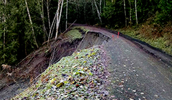
Mt. Baker Highway 542 is CLOSED at the Mt. Baker Ski Area (mile post 55) for the remainder of the winter season. Access to the Heather Meadows Area, Artist Point and trails including Artist Ridge, Table Mountain, Chain Lakes, Ptarmigan Ridge, Lake Ann, Fire And Ice and Bagley Lakes is limited due to snow cover, avalanche terrain and ski area operations. Mt. Baker Highway 542 has been reduced to one lane controlled by traffic light at mile 39.6, approximately 5 miles east of the town of Glacier, Washington due to an embankment failure.
Forest Service Road 39 (Glacier Creek Road) is blocked by downed trees at mile .85, just before the Thompson Creek Bridge. This limits access to the Heliotrope Ridge Trail and the Coleman-Deming climbing route for Mt. Baker. Forest Service Road 37 (Deadhorse Creek Road) is accessible to mile 8.5 before turning to snow. This limits access to the Skyline Divide trail where snow travel and route finding skills are required.
Forest Service Road 31 (Canyon Creek Road) is CLOSED at mile 4 from a landslide with large trees and debris. There is also tree debris on the road before the closure. The Damfino Lakes Trail and Canyon Ridge Trail are not accessible via Canyon Creek Road, but are still accessible via the Excelsior Pass Trail from State Highway 542.
Forest Service Road 3040 (East Church Mountain Road) is CLOSED at mile 1.7 due to debris across the road, and high clearance vehicles are recommended for the first section of the road. This cuts off vehicle access to the Church Mountain Trail.
Forest Service Road 11 (Baker Lake Road) is CLOSED at mile 22.8, approximately 2 miles from the Baker River Trailhead and North Baker Lake Trail access, due to a large mass of trees and debris over roadway.
Forest Service Road 17 (Finney Cumberland Road) is CLOSED at mile 17.6 due to a debris-blocked culvert that resulted in concrete footing damage. No trail access has been affected by this closure.
Forest Service Road 15 (The Cascade River Road) is CLOSED at Highway 20 due to multiple washouts and downed trees blocking the road. This closure blocks access to Cascade Pass and the Hidden Lakes Trail & Lookout.
As of today, little or no information is available concerning secondary Forest Service roads on the Mt. Baker Ranger District. Please check the current conditions section of this website for updates, or call the Mt. Baker Ranger District at 360-856-5700.
###
USDA is an equal opportunity provider, employer and lender. To file a complaint of discrimination, write: USDA, Office of the Assistant Secretary for Civil Rights, Office of Adjudication, 1400 Independence Ave., SW, Washington, DC 20250-9410 or call (866) 632-9992 (Toll-free Customer Service), (800) 877-8339 (Local or Federal relay), (866) 377-8642 (Relay voice users)
Alerts & Warnings
- Mallardy Ridge Trailhead and FSR 4030 and 4032 Closure
- Harris Lake Trailhead and FSR 5510 Closed
- Middle Fork Camping Closure
- Delays possible on PCT at the Summit at Snoqualmie Ski Area
- FSR 4110 Road Closure
- Camping Restrictions
- Fireworks and Explosive Targets Prohibition
- Read this Before Climbing or Backpacking on Mt. Baker
- Hwy 542 Closed to Artist Point
- New food storage rules for Mt. Baker-Snoqualmie NF
- Alcohol Prohibitions