
Official websites use .gov
A .gov
website belongs to an official government organization in the
United States.
Secure .gov websites use HTTPS
A lock
(
) or https:// means you've safely
connected to the .gov website. Share sensitive information only
on official, secure websites.


Santa Lucia Ranger District
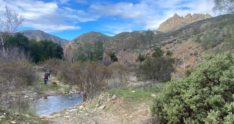
Springtime backpacking on the Manzana Creek Trail , San Rafael Wilderness
Date: June 19, 2024
Know Before You Go!
- Santa Lucia Ranger District: 805-925-9538. Press #1 for road and recreation site conditions/open/closed areas. Press #0 to reach a visitor information assistant.
- The office in Santa Maria is open Monday-Friday, 8:00am - 4:30pm. Closed weekends and federal holidays.
- The office is located at 1616 N. Carlotti Drive, Santa Marica, CA 93454.
- Check weather conditions before you head out into the forest. Locations: Santa Maria/Santa Ynez Valley/San Luis Obispo/Pozo/Astascadero The National Weather Service
- Contact www.recreation.gov to make or cancel a camping reservation or call 1-877-444-6777.
- Parks Management Company - www.campone.com or email: customerservice@pmcparks.com
Forest Orders
Special Closure - Public Health and Safety 5-07-53-24-05
Extended road closure - Black Mountain and Navajo Roads to close for construction work
Navajo Road (NFS Road 29S02.1) beginning at Turkey Flat OHV Staging Area and Black Mountain Road (NFS Road 29S10) beginning at the 5-Points road/trail junction and continuing to the end of the road at the top of Black Mountain on the Santa Lucia Ranger District will be closed to the public for road repairs.
Repair work will begin the week of April 1 and is estimated to be completed by the beginning of July. The project includes the installation of Mechanically Stabilized Earth (MSE) retaining walls and drainage features to ensure that water is diverted off the road without destabilizing the roadbed during extreme rain events.
During the construction period, Turkey Flats OHV Staging Area and the OHV trails in the Pozo area will remain open to the public as long as riders respect the closure area. There will also be no legal access to La Canada OHV trail (NFS Road 18E02) for vehicles over 50-inches wide. Repair crews will provide access to permit holders and emergency vehicles as needed during construction. However, Navajo and Black Mountain Roads will be closed to all public traffic, including hikers, bicyclists, and horseback riders until the project is completed.
Special Closure Order - Public Health & Safety: Effective: January 27, 2024 - August 31, 2024
- Special Closure Order Map - Exhibit B-1 (Santa Lucia Ranger District)
- Special Closure Order Map - Exhibit B-3 (Santa Lucia Ranger District)
- Special Closure Order Map - Exhibit B-4 (Santa Lucia Ranger District)
- Special Closure Order Map - Exhibit B-5 (Santa Lucia Ranger District)
Many of the areas that were closed for public health and safety concerns following powerful 2023 winter storms that inflicted significant damage across the Forest have reopened.
A new Forest orders are now in place that will keep severely compromised roads, trails, campgrounds, and day-use sites closed to the public while Forest engineers, partner groups, volunteers, and contractors work on repairs as funding becomes available. Road crews and resources from other national forests in California have been assisting with road clearing and maintenance projects to reopen additional areas once they have been repaired.
Target Shooting Prohibition
Firearms Prohibition Forest Order: Effective February 15, 2023 through December 31, 2024
Occupancy and Use Forest Order 5-07-00-24-02 effective February 6, 2024 through February 5, 2026
Pursuant to 16 U.S.C. § 551 and 36 C.F.R. § 261.S0(a), and to provide for public safety and protect natural resources, the following act is prohibited within the Los Padres National Forest. This Order is effective from February 6, 2024, through February 5, 2026.
1. Camping:
a. in a developed campground, for a period longer than 14 consecutive days or for more than 28 days during a calendar year; or
b. anywhere other than a developed campground, for a period longer than seven consecutive days or for more than 21 days during a calendar year.
36 C.F.R. § 261.58(a).
Forest Order 05-07-53-22-05 West Cuesta Fire Use Restrictions. This Order is effective from September 16, 2022, through September 15, 2024.
West Cuesta Ridge Rd (TV Tower Rd)
Open Campgrounds
- Bates Campground (Hwy 166)
- Baja (Rockfront OHV Area)
- Buck Springs (Rockfront OHV Area)
- Cerro Alto Campground is open, but due to storm damage, sites# 4,5,6 and 7 are closed until further notice.
- Davy Brown Campground
- Figueroa Mountain Campground
- Hi Mountain Campground
- Miranda Pine (Sierra Madre Rd)
- Navajo Flat (Pozo/La Panza area)
- Nira Campground
- Turkey Flat (Pozo/La Panza area)
Temporarily Closed Campgrounds
- American Canyon Campground - Only open during Zone A Deer Hunting Season (Aug-September)
- Barrel Springs Campground
- Brookshire
- Friis (Pozo/La Panza OHV Area)
- Horseshoe Springs
- La Panza Campground
- Paradise (Rockfront OHV Area) - inaccessible due to Paradise Rd/Trail closure (Trail 26)
- Wagon Flat
Rockfront Ranch OHV Area
Open
There are still a few trails in Rockfront that are not open to the public yet. These are: Paradise 17E08 (Trail 26) and Twin Rocks 17E12 (Trail 30). These trails are marked at Rockfront. Repairs to these trails are ongoing.
Baja and Buck Springs campgrounds will be open when Rockfront re-opens after the upcoming storms and will be accessible. Paradise campground is inaccessible due to the closure of Paradise Trail.
Pozo OHV Trailheads/Staging Areas
Open
- Navajo Flat OHV Staging Area
- Turkey Flat OHV Staging Area
Pozo/La Panza OHV Trails
Open
- 15E05 Howard’s Bypass OHV Trail
- 15E07 Powerline OHV Trail
- 16E22 McGinnis Creek OHV Trail
- 116E04 Queen Bee OHV Trail
- 16E08 Las Chiches OHV Trail
- 16E09 Pine Mountain OHV Trail
- 16E16 Mare Springs OHV Trail
- 116E21 Burnout OHV Trail
- 6E02 Las Chiches Cut-Off OHV Trail
- 18E02 La Canada Trail
- 18E05 La Panza OHV Trail
- Navajo Flat OHV Staging Area
- 16E23 Navajo Bypass OHV Trail
- 16E24 Tower OHV Trail
- Turkey Flat OHV Staging Area
- 28S02A Benchmark OHV Road
Temporarily Closed Roads
- Black Mouintain Rd 29S10
- Navajo Road 29S02.1
Open Roads
- Bates Canyon Rd from the campground up to Sierra Madre Rd
- Figueroa Mountain Rd to Cachuma Saddle
- Figueroa Lookout Rd to the Pino Alto Picnic Area and Lookout Day Use Area
- Happy Canyon Rd
- Hi Mountain Rd
- Pozo Summit Rd
- Sierra Madre Rd from Hwy 166 to McPhearson Peak and Miranda Pine Campground
- Sunset Valley Rd to Davy Brown and Nira Campgrounds and the trailheads to the Manzana Creek trail
- West Cuesta/TV Tower Rd
- 8N02 / Zaca Ridge Rd
- 8N02A / Zaca Peak OHV Rd
Open Hiking Trails
- Davy Brown Trail from Figueroa Mountain
- La Jolla Trail - Figueroa Mountain
- White Rock Trail - Figueroa Mountain
- Munch Trail - Figueroa Mountain
- Willow Springs - Figueroa Mountain
- Manzana Creek Trail West to Manzana Schoolhouse
- Manzana Creek Trail East to Manzana Narrows
- Cerro Alto Trail
- East Cuesta Ridge Road (hiking or bicycles only - no vehicles) and trails off of Hwy 101 - Cuesta Grade
- Adobe Trail - Off of Hwy 166
- Gifford Trail - Off of Hwy 166
- Willow Springs Trail - Off of Hwy 166
Open Midland School Hiking Trails - Figueroa Mountain Area
Temporarily Closed Figueroa Mountain OHV Trails
- East Pinery
Open Figueroa Mountain OHV Trails
- 29W02 Catway OHV Trail
- 8N02A / Zaca Peak OHV Road
Figueroa Mountain Day Use Areas
Open
Permanently closed campgrounds
- Colson Campground
La Brea Area road and trail closures
La Brea/Colson area past the Colson Campground (Forest Road 11N04).
-
Forest Order 05-07-53-22-11 La Brea Road Closure Expires: 9-2-2023
- Forest Order 05-07-53-22-11 La Brea Road Closure Map
La Brea Area campground closures
- La Brea Area: Barrel Springs, Wagon Flat
- Buckhorn Ridge OHV Area - Bear Canyon Campground
Buckhorn Ridge OHV Area Rd and OHV riding Area/trail closures
- Buckhorn Ridge OHV Area (Buckhorn Ridge, Horshoe Spring Spur, Bear Canyon Loop and Bear Canyon Campground).
- Kerry Canyon OHV Trail/Area is temporarily closed until further notice.

![[image] Tread Lightly Brochure Photo](/Internet/FSE_MEDIA/fseprd553420.jpg)


