
Official websites use .gov
A .gov
website belongs to an official government organization in the
United States.
Secure .gov websites use HTTPS
A lock
(
) or https:// means you've safely
connected to the .gov website. Share sensitive information only
on official, secure websites.


Sierra & Elko Fronts Wildfire Crisis Landscape
Wildfire Crisis Landscapes
The Sierra and Elko Fronts, a Wildfire Crisis Landscape Project on the Humboldt-Toiyabe National Forest, was selected to receive a historic investment of $53 million in 2023 to support the USDA Forest Service’s National Wildfire Crisis Strategy. Landscapes were chosen based on the potential for wildfire to affect nearby communities, critical infrastructure, public water sources, and Tribal lands. The Forest was positioned well given current efforts around the Nevada Shared Stewardship Agreement, an interagency collaboration effort that has previously identified wildfire crisis landscapes across the state based on similar threats to public and private land.
The wildfire crisis landscape projects are a large-scale effort to reduce the risk of wildfire to protect at-risk communities and critical infrastructure, while also increasing the landscape’s resilience and ability to survive the effects of changing climates and other stressors such as insects, disease, and invasive species. Selected wildfire crisis landscapes will advance the goals of the Wildfire Crisis Strategy by utilizing the best available science and strategic network of hazardous fuels and vegetation treatments to reduce wildfire risk.
Wildfire crisis landscapes, also known as firesheds, are large forested and rangeland areas where communities, infrastructure, and natural resources are at the highest risk to be impacted by wildfire. Examples include critical watersheds and wildlife habitats; utility, energy, and mining facilities; transportation corridors; and recreation areas. Several high risk firesheds were identified on the Humboldt-Toiyabe National Forest, including the Sierra and Elko Fronts.
Combined with the initial ten selected landscapes in 2022, the wildfire crisis landscape projects now span nearly 45 million acres across 137 of the 250 high-risk firesheds in the western United States. More than $930 million will be invested in 21 landscapes across 26.7 million acres. This work will mitigate risk to approximately 200 communities within these selected landscapes.
Wildfire Crisis Strategy
Since releasing its Wildfire Crisis Strategy one year ago, the Forest Service and its partners have used the best available science and data to identify the highest-risk landscapes for treatment projects. The Forest Service found that around 80 percent of the wildfire risk to communities is concentrated in less than 10 percent of “firesheds,” or areas where wildfires are likely to threaten communities and infrastructure. These targeted investments focus on firesheds of the highest risk, where projects are ready to begin or to expand.
The 10-year strategy calls for treating up to 20 million acres of national forests and grasslands and up to 30 million acres of treatments on other federal, state, Tribal, private, and family lands. It also includes developing a plan for long-term maintenance beyond the 10 years.
Over the past 20 years, many states have had record catastrophic wildfires, devastating communities, lives, and livelihoods and causing billions of dollars in damage. More than 10 million acres – more than twice the size of New Jersey – burned each year across the U.S. in 2020, 2017, and 2015.
The Wildfire Crisis Strategy builds on current work and leverages congressional authorities and partnerships to support USDA’s work to mitigate wildfire risk and restore forest health over the next decade. In addition to State Forest Action Plans , the strategy also aligns with the Collaborative Forest Landscape Restoration Program , Tribal Forest Protection Act , Good Neighbor Authority , Joint Chiefs’ Landscape Restoration Partnership and Shared Stewardship agreements.
In June 2022, USDA released the Secretary’s Memorandum on Climate Resilience and Carbon Stewardship of America’s National Forests and Grasslands. The Secretary’s memo builds on previous actions on climate change, equity, and forest resilience but provides more specific and time-bound actions to integrate into agency programs.
The Forest Service has used the Secretary’s guidance for selection criteria to identify projects under the Wildfire Crisis Strategy, including equity, source water protection, community infrastructure, and wildlife corridors. Recognizing that insects, disease, and wildfire are among the most significant threats to mature and old-growth forests, the Forest Service has begun and will continue targeting hazardous fuels reduction projects to address these threats.
Sierra and Elko Fronts Landscape Project
 The Sierra and Elko Fronts Landscapeencompasses approximately 3.4 million acres of Forest Service and Bureau of Land Management lands adjacent to the metropolitan areas of Reno, Sparks, Carson City, and Elko, Nevada, and approximately 33 other rural communities in northeastern and western Nevada and a small portion of eastern California. Around 1.3 million acres of the landscape are located on the Humboldt-Toiyabe National Forest.
The Humboldt-Toiyabe National Forest will work within and across forest boundaries with state, federal, and tribal partners to treat 200,000 to 300,000 acres of National Forest System lands within the Sierra and Elko Fronts Landscape over the next 10 years.
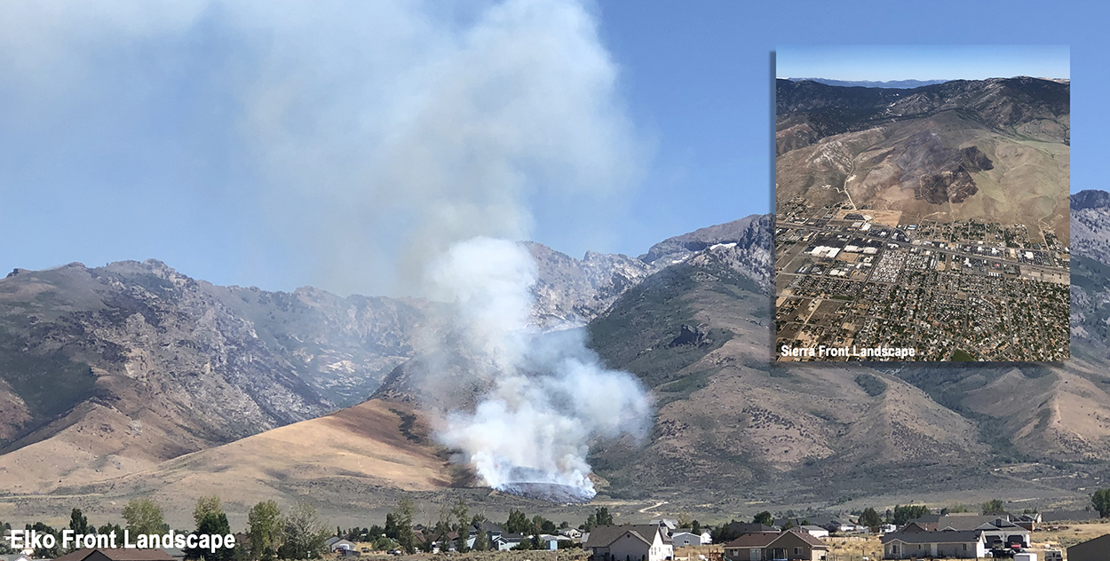
Sierra Front Landscape
-
Approximately 2 million acres, including National Forest System and Bureau of Land Management. About 810,000 acres of this landscape area is located on National Forest System lands.
-
Located in western Nevada and small portion of eastern California. This landscape area lies adjacent to the Reno-Sparks Metropolitan area, Carson City, and 10 other rural communities, with a total population of more than 600,000 people.
-
Fire hazard on about 41 percent of the landscape area is classified as high or very high, threatening watersheds, native plants, wildlife habitats, recreational infrastructure, and private property.
-
The Carson, Truckee, and Walker Watersheds are located in the landscape area and a major source of drinking and irrigation water for approximately 600,000 people.
-
Over 366 miles of major transmission lines are located in the landscape area and support the population in western Nevada and portions of eastern California.
-
Recreational values and infrastructure in the Sierra Front Landscape area support around 1.5 million visitors a year.
Elko Front Landscape
-
Approximately 1.4 million acres, including National Forest System and Bureau of Land Management. About 340,000 acres of this landscape area is located on National Forest System lands.
-
The Elko Front Landscape is in northeastern Nevada. This landscape area surrounds 23 rural communities, including the City of Elko, with a total population of 60,000 people.
-
Fire hazard on about 81percent of the landscape area is classified as high or very high, threatening watersheds, native plants, wildlife habitats, recreational infrastructure, and private property.
-
The Upper Humboldt Watershed is located in the landscape area and a major source of drinking and irrigation water for 60,000 people.
-
Over 84 miles of major transmission lines are located in the landscape area ;and support the population in northeastern Nevada.
-
Recreational values and infrastructure in the Elko Front Landscape area support over 500,000 visitors a year.
-
Sierra & Elko Fronts Stories and News Releases

Read how the Forest is working with local, state, county, and federal agencies, Tribes, and other partners to address wildfire risks on the Sierra and Elko Fronts Wildfire Crisis Strategy Landscape.
Ongoing Efforts
The Humboldt-Toiyabe National Forest’s cross-boundary strategy for reducing long-term wildfire risk, improving native vegetation and wildlife habitat, and addressing forest and rangeland resiliency includes:
-
Mechanical treatments
-
Targeted grazing for fine fuels reduction
-
Manual and chemical treatments for non-native annuals and noxious weeds
-
Create and/or strengthen fuel breaks
-
Prescribed fire
-
Improve existing roads to provide access and operational delineation points for firefighter safety and effectiveness during fire suppression
Accomplishments to Date
Sierra Front Landscape
In the last three years, approximately 24,000 acres of restoration treatments have been accomplished, which helped reduced wildfire risk, protect water quality and wildlife habitat, and improve forests and rangelands health. A shared stewardship approach focused efforts towards coordinating treatments across jurisdictional boundaries around the wildland urban interface in communities such as Reno, Carson City, Gardnerville, and Minden in Nevada and Woodfords, Markleeville, Coleville, Walker, Bridgeport, and Twin Lakes in California.
Efforts for restoring native plant and animal species have been underway and include partnering with researchers and local counties to treat invasive plants and promote native vegetation. Bi-State Sage-Grouse restoration projects have also included partnering with the State of Nevada and Tribes to perform treatments to improve the sagebrush ecosystem. Finally, treatments around aspen stands have been a part of project planning and implementation to enhance aspen communities and associated habitats.
Elko Front Landscape
In the last three years, approximately 18,000 acres of restoration treatments have been accomplished, which helped reduced wildfire risk, protect water quality and wildlife habitat, and improve forests and rangelands health. A shared stewardship approach focused efforts towards coordinating treatments across jurisdictional boundaries around the wildland urban interface in communities such as Elko, Spring Creek, Lamoille, Shanty Town, and Ruby Lakes Estates in Nevada.
Efforts for restoring native plant and animal species have been underway and include partnering with researchers and local counties to treat invasive plants and promote native vegetation. Greater Sage Grouse restoration projects have also included partnering with the State of Nevada, Bureau of Land Management, and Tribes for perform treatments to improve the sagebrush ecosystem. Finally, roadside fuel breaks have been created or strengthened across public and state lands to improve the effectiveness of wildfire suppression.
Next Steps
Current and future efforts for planning and implementation of hazardous fuels and vegetation treatments will continue to follow a shared stewardship approach for meeting multiple restoration objectives across jurisdictional boundaries. Treatments focused on the Sierra and Elko Fronts Landscapes will utilize the best available science and modelling to prioritize the timing, method, and location.
An increase in funding because of the Bipartisan Infrastructure Law and Inflation Reduction Act will contribute towards a significant increase in the pace and scale of treatments. In Fiscal Year 2023 and 2024, the Humboldt-Toiyabe National Forest intends to obligate funding into contracts and agreements over several years to conduct initial and maintenance treatments over the course of the next 10 years.