
Official websites use .gov
A .gov
website belongs to an official government organization in the
United States.
Secure .gov websites use HTTPS
A lock
(
) or https:// means you've safely
connected to the .gov website. Share sensitive information only
on official, secure websites.


Fires Update May 26, 2016: Cowboy, Mormon, and Pivot Rock fires, managed for multiple benefits and objectives
Release Date:
Contact(s): Media Contact: George Jozens 928-527-3412, Media Contact: Adam Solt 435-201-0856
Update: Information regarding the Mormon Fire area closure was added to this release since the original press release was issued to the media.
Flagstaff, Arizona — Fire managers with the Coconino National Forest continue to make use of three lightning-caused fires to benefit the landscape and maintain a healthy ecosystem.
Information and details about the fires, including their objectives, will be updated on Inciweb. Quick updates will also be provided on @CoconinoNF on Twitter, so please follow us if you would like to be updated as information is received. The public can report smoke impacts online.
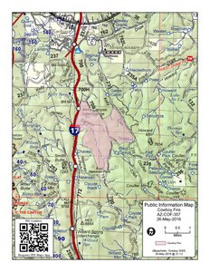
COWBOY FIRE OVERVIEW
- Start Date: May 17, 2016.
- Cause: Lightning.
- Location: Approximately eight miles south of Flagstaff, near milepost 331 on the immediate east side of Interstate 17.
- Current Size: Approximately 2,170 acres.
- Resources: 1-Type 1 Handcrew (Flagstaff Hotshots), 2-Type 3 Engines, 2-Type 6 Engine, and 15 other personnel.
- Smoke: Smoke impact on Interstate 17 near the Kelly Canyon Road and milepost 331 this morning were noticeable. In the Mountainaire, Kachina Village and Kelly Canyon smoke impacts were moderate. Smoke from the fire has been settling in valleys at night and drifting to the north and east during the day. Winds are expected to be out of the southwest today at 10 to 15 mph. Smoke impacts should be expected along the Lake Mary Road and recreation corridor, campgrounds (Double Springs, Dairy Springs, Pinegrove, Lakeview, and Canyon Vista Campgrounds), day-use areas (Narrows, and Lower Lake Mary), Walnut Canyon National Monument, and communities north and northeast of the fire including East Flagstaff, Doney Park, Country Club, Winona, Mountainaire and Kachina Village. Smoke may impact the Arizona, Sandys Canyon and the Flagstaff Loop trails.
- Closures: None Currently. Drivers in the area are advised to use caution as fire fighters are on foot and several vehicles are operating in the burn areas.
- Operations Today: Burnout operations were planned for the day, but because of winds and potential for storms there will not be any burnouts today. Some resources will transfer to the Mormon Fire for the day. Burnout operations are planned again for Tuesday (May 31) along Interstate 17 at Newman Park. Arizona Department of Transportation and the Department of Public Safety Highway Patrol officers will be monitoring smoke and traffic along Interstate 17. The posted speed limits may be lowered on the Interstate along the fire perimeter for public safety.
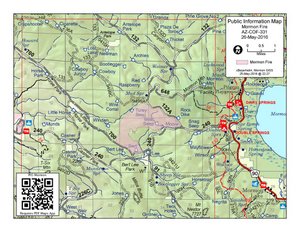
MORMON FIRE OVERVIEW
- Start Date: May 15, 2016.
- Cause: Lightning.
- Location: Six miles east of Munds Park near Mormon Mountain.
- Current Size: Approximately 1,200 acres.
- Resources: 1-Type 1 Crew (Mormon Lake Hotshots), 2-Type 2 Incident Attack Crews (BearJaw and Coconino Fuels Crew 4), 2-Type 3 Engine, 3-Type 6 Engines, 1-Dozer, and 20 other personnel.
- Smoke: Smoke may settle in drainages and valleys including Mormon Lake and Munds Park at night. Smoke will disperse during the day to the north and east. Winds are expected to be out of the west today at 10 to 15 mph. Smoke impacts along the Lake Mary Road and Mormon Lake recreation corridor will be possible. This includes campgrounds (Double Springs, Dairy Springs, Pinegrove, Lakeview and Canyon Vista Campgrounds), day-use areas (Narrows, and Lower Lake Mary), Walnut Canyon National Monument, and many trails in the area, to include the Arizona Trail. In conjunction, communities north and northeast of the fire including East Flagstaff, Doney Park and Winona may experience smoke impacts.
- Closures: There is a new closure for the Mormon Fire, in Coconino County, east of Mormon Lake at the base of the eastern flank of Mormon Mountain through June 26, 2016. See the Mormon Fire Area Closure (Forest Order 04-16-07-F) for a map and details. Drivers in the area are advised to use caution as fire fighters are on foot and several vehicles are operating in the burn areas.
- Operations Today: Burnout operations will begin around midday on the eastern portion of the fire. Work will be done to prepare the boundaries for future burnout operations on the north and northeast portions of the fire.
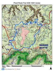
PIVOT ROCK FIRE OVERVIEW
- Start Date: May 19, 2016.
- Cause: Lightning.
- Location: About three miles northeast of junction state Arizona Highways 260 and 87; about eight miles northeast of Strawberry.
- Current Size: Approximately 1,000 acres.
- Resources: 1-Type 2 Crew (Blue Ridge Hotshots), 2-Type 3 Engines, 3-Type 6 Engines, 1-Dozer, 1-Water tender, and 15 other personnel.
- Smoke: Smoke will be visible from Arizona Highways 260 and 87 as well as the communities of Payson, Pine, Strawberry, the Verde Valley and Happy Jack. In the evening, smoke from the Pivot Rock Fire is expected to settle into low areas and nearby canyons, including Toms Creek, Clover Canyon, Pivot Rock Canyon and into West Clear Creek. Fire activity is moderate.
- Closures: There is a closure for the Pivot Rock Fire, in Coconino County, near the intersections of Arizona Highways 260 and 87 through June 24, 2016. See the Pivot Rock Area Closure (Forest Order 04-16-06-F) for a map and details. Drivers in the area are advised to use caution as fire fighters are on foot and several vehicles are operating in the burn areas.
- Operations Today: Management ignitions planned for yesterday were canceled. Ignitions began today at 10:00 a.m. In order to mitigate smoke impacts, fire managers are not planning any management ignitions through the Memorial Day holiday weekend.
News, notices, and information may be found through the following resources:
- Inciweb: Coconino NF Incidents
- Coconino National Forest Supervisor's Office: 928-527-3600
- @CoconinoNF on Twitter
- Coconino National Forest: News and Events
Additional resources: