
Official websites use .gov
A .gov
website belongs to an official government organization in the
United States.
Secure .gov websites use HTTPS
A lock
(
) or https:// means you've safely
connected to the .gov website. Share sensitive information only
on official, secure websites.


About the Area - Local Links
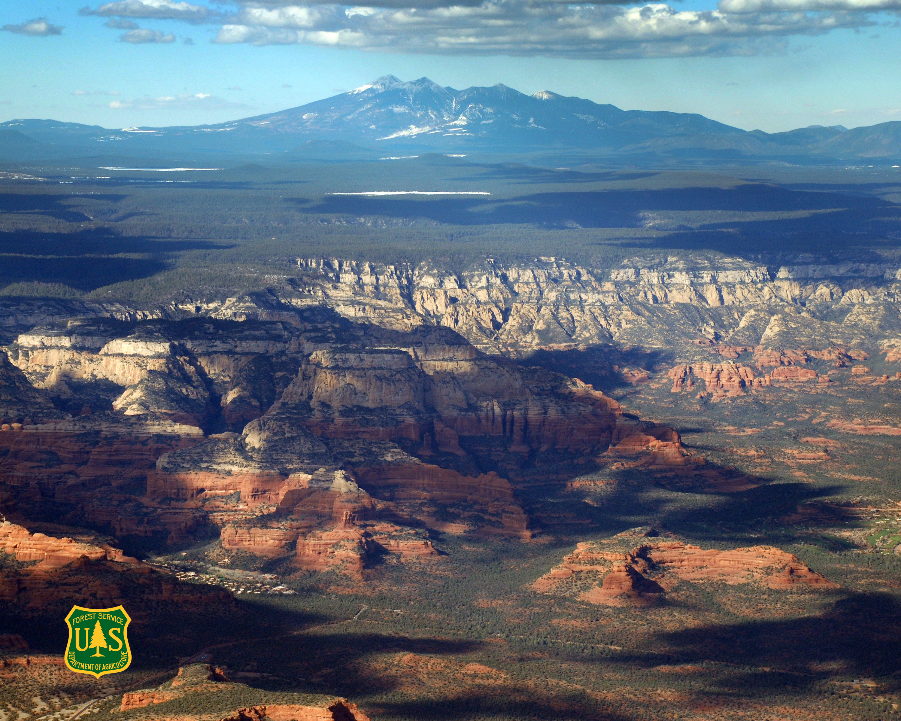
One of six National Forests in Arizona, the Coconino National Forest comprises 1.856-million acres in northern Arizona, with elevations ranging from 2,600 feet to the highest point in Arizona at 12,633 feet (Humphrey's Peak).
Originally established in 1898 as the "San Francisco Mountains National Forest Reserve,” the area was officially designated a National Forest by Pres. Theodore Roosevelt on July 2, 1908 when the San Francisco Mountains National Forest Reserve was merged with lands from other surrounding forest reserves to create the Coconino National Forest.
Today, the Coconino National Forest contains diverse landscapes, including deserts, ponderosa pine forests, flatlands, mesas, alpine tundra, and ancient volcanic peaks. The forest surrounds the towns of Sedona and Flagstaff and borders four other national forests; the Kaibab National Forest to the west and northwest, the Prescott National Forest to the southwest, the Tonto National Forest to the south, and the Apache-Sitgreaves National Forest to the southeast. The forest contains all or parts of 10 designated wilderness areas, including the Kachina Peaks Wilderness, which includes the summit of the San Francisco Peaks. The Coconino National Forest consists of three districts: Flagstaff Ranger District, Mogollon Rim Ranger District, and Red Rock Ranger District--which have local ranger stations in Flagstaff, Happy Jack, and Sedona. The headquarters, or Supervisor’s Office, is in Flagstaff.
Statistics
- Size: 1.8 million acres
- Designated Wilderness Areas: 10 (The forest contains all or parts of these areas.)
- Full-time Employees: 230 to 280
- Developed Campgrounds: 24
- Cabin Rentals: 4
- Archaeological/Heritage Sites: 4
- Annual Visitors: 5.532 million (based on 2020 National Visitor Use Monitoring report)
- Fire Lookouts: 10
- Miles of Open Forest Roads: Approx. 3,300
- Miles of Trails on Forest: 693
- Number of Trails on Forest: 161
Related and Local Links
- FAQs (Frequently Asked Questions)
- Friends of the Forest, a volunteer group in Sedona.
- Friends of Northern Arizona Forests, a volunteer group in Flagstaff.
- History of the San Francisco Peaks and how they got their names
- Red Rock Pass Program
- Pick-a-Forest, Any Forest by State.
- Rocky Mountain Research Station
- U.S. Department of Agriculture - The department which the U.S. Forest Service falls under.
- U.S. Forest Service "JOBS" website - Access information about jobs with the Forest Service
- U.S. Forest Service R3; - Southwestern Region 3's main website.
- U.S. Forest Service WO - Washington D.C. main website.
- Arizona 2-1-1 - was created to help you easily find resources from child care, jobs, healthcare and insurance - to State and local emergency bulletins and alerts that are vital in times of disaster or emergency. Arizona 2-1-1 Online was developed in partnership with government, tribal, non-profit and community groups to help you find the resources and information you need."
- Arizona Association for Environmental Education - AAEE is a nonprofit organization working to enhance the quality of environmental education in Arizona and to advance professionalism among all who are involved with environmental education, whatever the topic or setting.
- Arizona Department of Transportation - Status of highways and roads.
- Arizona State Game and Fish Department
- City of Flagstaff
- City of Flagstaff Wildland Fire Management
- Coconino County Emergency Services
- Greater Flagstaff Forests Partnership
- Kids.GOV - Our site links to more than 1,200 kid-friendly web pages and is organized around three audiences: Grades K-5, Grades 6-8, and a new section for Educators.
- National Park Service, U.S. Department of the Interior
- National Weather Service - For Flagstaff area.
- Society for Range Management, Arizona Section site is hosted by The University of Arizona College of Agriculture and Life Sciences in Tucson, Arizona
- University of Arizona Cooperative Extension, Coconino County
- USA Jobs
- Where the Other YOU Lives - Imagine a place where you can be different... or just be yourself. Where you can be silly and muddy, or thoughtful and curious...
- Arboretum at Flagstaff
- Arizona Natural History Association
- Arizona Trail Association
- Arizona Watchable Wildlife Experience - a community partnership committed to connecting people with Arizona's natural environment and promoting its conservation.
- Discover Flagstaff
- Leave No Trace Ethics
- Kachina Peaks Avalanche Center - avalanche information
- Keep Sedona Beautiful - assisting in the preservation of Sedona and its surroundings by all appropriate means.
- Public Lands Information Center
- Tread Lightly! Inc. - is a non-profit organization that is dedicated to informing outdoor enthusiasts about outdoor ethics regarding the responsible use of natural resources. Tread Lightly! Inc. develops and distributes educational materials to the public, focusing on the responsible use of off-highway vehicles (OHV's) and other forms of mechanical travel, and the principles of conducting recreation activities to protect the environment.