

Welcome to Carson National Forest
The Carson National Forest spans 1.5 million acres of Northern New Mexico, encompassing portions of the Sangre de Cristo Mountains, San Juan Mountains and the San Juan Basin. With elevations ranging from 6,500 to over 13,000 feet, the forest boasts diverse ecosystems, from the sagebrush to alpine and tundra.
Visitors can enjoy a wide range of outdoor activities, including hiking, mountain biking, camping, hunting and fishing. The forest is also home to New Mexico's tallest point, Wheeler Peak.
The Latest
Transmission Line Fuels Clearance in Taos Canyon

Tri-State Generation and Transmission Association is conducting fuels mitigation to reduce the risk of wildfires within its right-of-way for a 115kV transmission line that spans Forest Service land between Black Lake and Taos.
Early Fall Prescribed Fires Planned
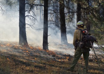
Fire managers will potentially move forward with several prescribed fires in the first half of fall 2025. The exact timing of each will depend on specific wind, weather, moisture conditions, available personnel/equipment and required approvals.
Applications for Permanent Fire Positions Now Open

Applications will be due through USAJobs.gov by September 23. Open positions are now listed.
Know Before You Go
Current Conditions

Summertime is monsoon season, which brings numerous weather hazards.
Douglas-Fir Tussock Moths

It’s a native insect, essentially doing its thing, but there are safety concerns when you're around them.
One Less Spark

Protect the forest and surrounding communities by following these fire-safe practices.