
Official websites use .gov
A .gov
website belongs to an official government organization in the
United States.
Secure .gov websites use HTTPS
A lock
(
) or https:// means you've safely
connected to the .gov website. Share sensitive information only
on official, secure websites.


Winter 2024 Pile Burning
February 2024 Update
Pile burning operations are completed for the winter season. Crews continue to patrol and monitor any projects that have not yet been called out. Some piles could not be burned due to conditions, prescription and/or access.
Fire personnel plan to treat the piles treated in upcoming seasons. A list of potential spring projects is expected to be announced in March 2024.
Carson National Forest crews are planning to pile burn throughout the 2023-2024 winter weather season.
Piles were created from thinning projects in nearly a dozen locations, including near Canjilon, El Rito (Rio Arriba County), Hopewell Lake, Las Trampas, Ojo Sarco, Red River, San Cristobal, Taos Ski Valley and Tres Piedras.
Fire managers monitor weather and conditions for opportunities to implement each pile burn project during the winter weather season. As potential opportunities arise, public information officers will make notifications.
Pile Burning Locations
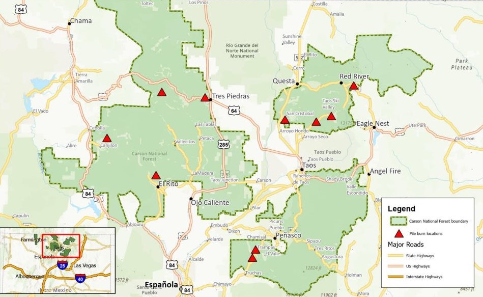
Numerous locations are currently planned and are listed below. Not all piles may be treated due to weather, conditions and personnel availability. New locations may be added.
| Nearby Location | Project Name | Acres* | Status |
|---|---|---|---|
| Canjilon | Canjilon Wildland Urban Interface Project | 102 | Partially Completed |
| El Rito | El Rito Canyon Restoration Project | 300 | Not Started |
| Hopewell Lake | Rio Tusas-Lower San Antonio Landscape Restoration Project |
550 | Completed |
| Trampas | Rio Trampas Project | 200 | Partially Completed |
| Ojo Sarco | Green Fuelwood Areas Project | 137 | Completed |
| Red River | Enchanted Forest Salvage Project | 50 | Not Started |
| San Cristobal Piles | Kiowa-San Cristobal Wildland Urban Interface Project |
29 | Completed |
| San Cristobal Jackpot | Kiowa-San Cristobal Wildland Urban Interface Project |
750 | Not Started |
| Taos Ski Valley (Hwy. 150/Wheeler Peak Trail) |
Hwy. 150 Corridor Wildland Urban Interface Project |
300 | Postponed |
| Taos Ski Valley (Resort) | Taos Ski Valley Special Use Permit |
100 | Partially Completed |
| Tres Piedras | Rio Tusas-Lower San Antonio Landscape Restoration Project |
500 | Not Started |
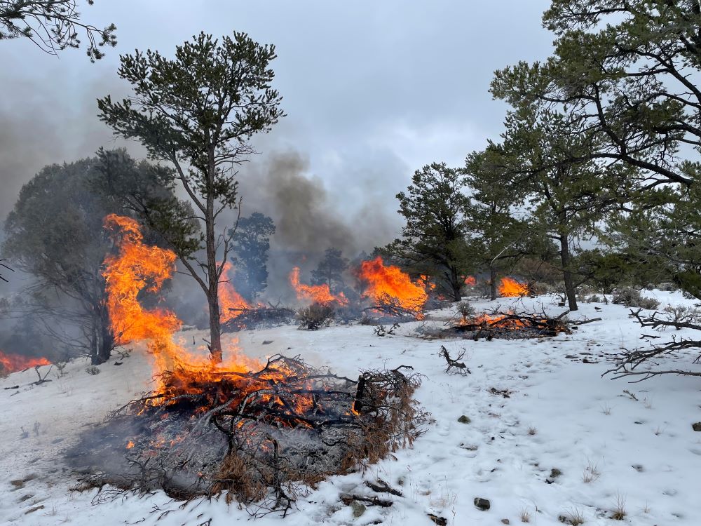
What is Pile Burning?
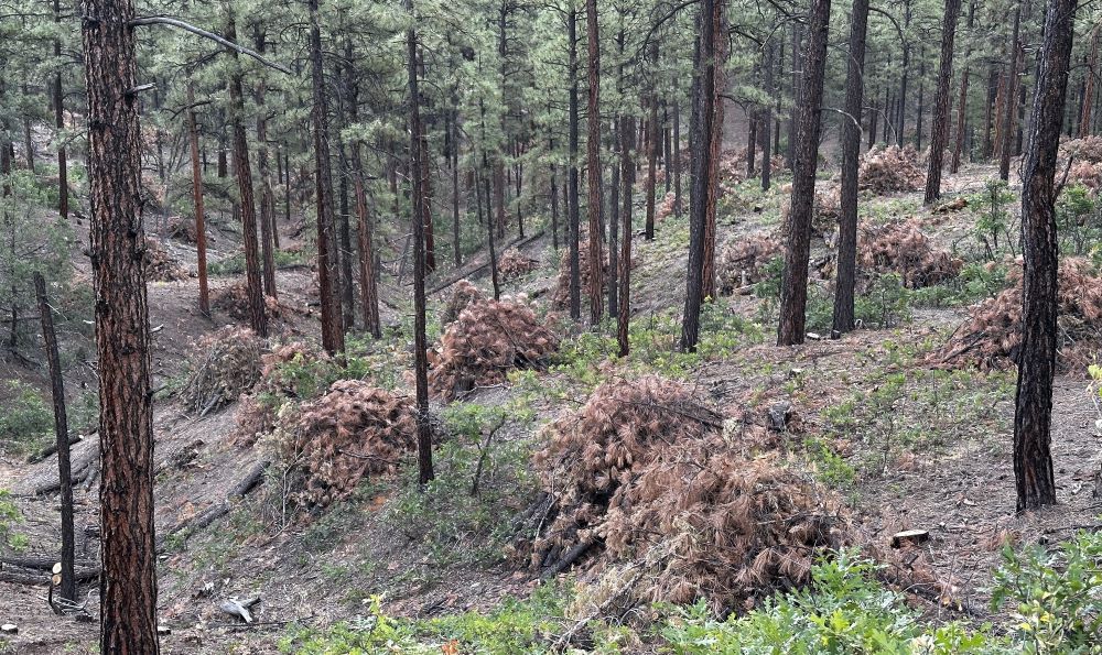
Piles burning is a type of prescribed fire, in which slash, like thin branches, are piled by thinning crews and treated with fire. Thinning is applied for different reasons in different areas:
-
In vegetation communities, like ponderosa pine, lightning-caused wildfires were historically frequent and low-intensity. Thinning is used in these areas to reduce unnaturally dense fuels to lay the ground work for understory burning or lightning –caused wildfires.
-
In other vegetation communities, like piñon woodlands and spruce-fir, lightning-caused wildfire were historically infrequent and high-intensity. Thinning is strategically placed near the wildland urban interface to moderate fire behavior and create defensible space for homes, communities and critical infrastructure, among other values that could be threatened.
This work is often complemented by members of the public who obtain permits to gather fuelwood in recently thinned areas.
It is ideal to pile burn after winter weather conditions have set in. The dampened or snow-covered forest floor reduces the chances a fire creeps away from piles.
The Big Picture
Thinning and prescribed fire are two of the most important tools of the Wildfire Crisis Strategy to promote healthier forests and reduce the risks of wildfire. Planned pile burning in the Carson National Forest this winter will contribute to major landscape projects across the forest.
Project work on the forest’s east side is within the Enchanted Circle Landscape, which covers 1.5 million acres in and around the Camino Real and Questa ranger districts. It is one of the most at-risk landscapes in the country and a priority of the Wildfire Crisis Strategy.
Work on the forest’s west side is within the Rio Chama Collaborative Forest Restoration Landscape Project, which covers the Canjilon, El Rito and Tres Piedras ranger districts and areas outside the forest in Northern New Mexico and Southern Colorado. It aims to protect communities while improving forest health in the Rio Chama and Rio Grande watersheds that are inextricably linked to the water needs of downstream cities, including in Santa Fe and Albuquerque.
Get Notified
Fire personnel try to give notice as early as possible, but a positive turn in the forecast and ground conditions may prompt a quick turnaround before ignitions.
Pile burning notices through a variety of means:
-
Forest neighbors and residents are encouraged to join the forest news release email list. Email mailroom_r3_carson@usda.gov with a request.
-
Forest visitors are encouraged to check the Alerts & Closures page on the Carson National Forest website or InciWeb before heading out.
-
Prescribed fire notices are also posted to forest social media (Facebook, X) and New Mexico Fire Information.
Operational updates during pile burning are posted to InciWeb. Depending on the location and/or public interest, such updates may extend to other forms of communication.