
Official websites use .gov
A .gov
website belongs to an official government organization in the
United States.
Secure .gov websites use HTTPS
A lock
(
) or https:// means you've safely
connected to the .gov website. Share sensitive information only
on official, secure websites.


Big Pines Recreation Area Brochure
Big Pines Recreation Area
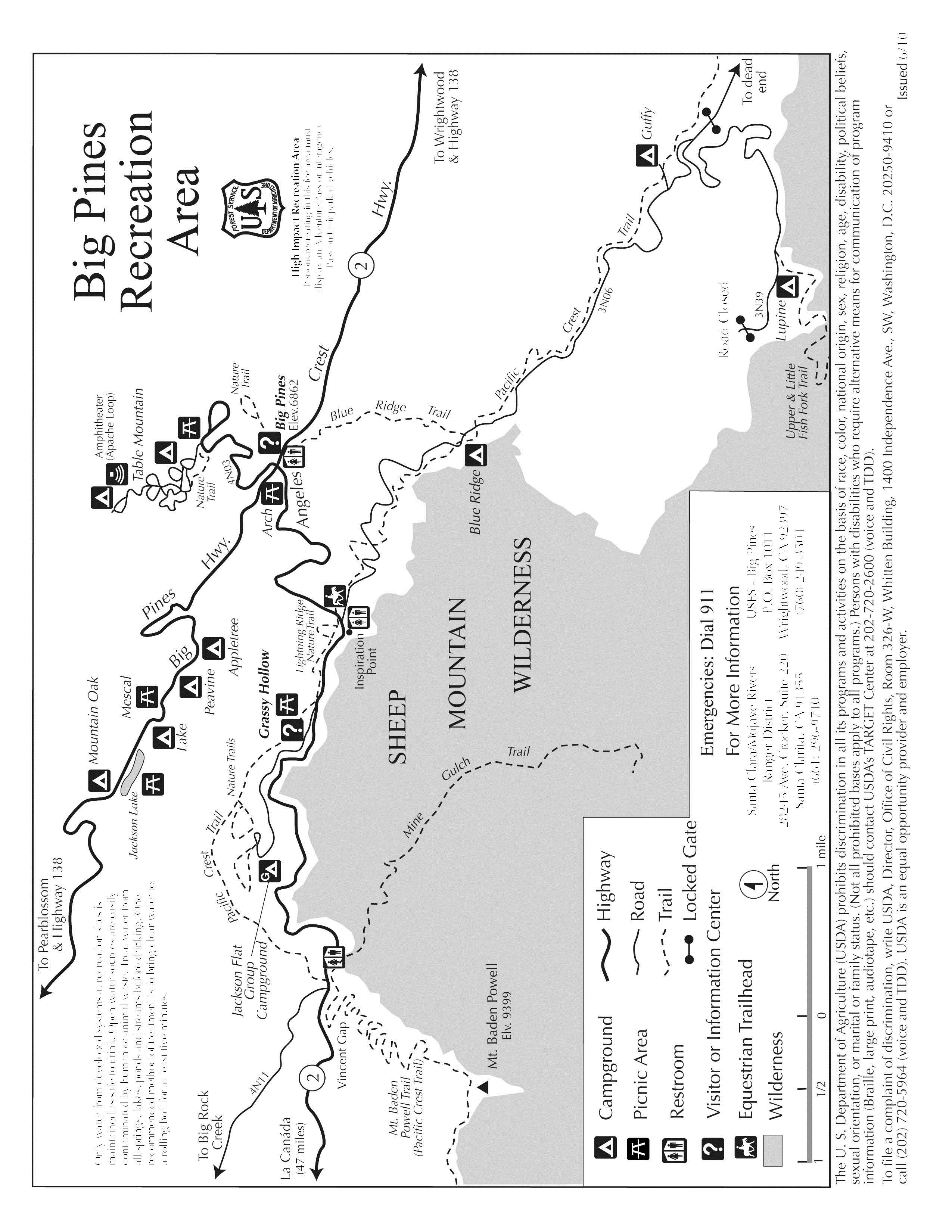
The Big Pines Recreation Area offers a variety of recreational opportunities and facilities for year-round enjoyment. Ten campgrounds and five picnic areas are available, and all provide tables, stoves and restrooms. Numerous hiking trails are in the area, including a section of the Pacific Crest Trail. Nearby Jackson Lake provides an opportunity for fishing and Grassy Hollow Visitor Center is just a few miles west of Big Pines.
During the summer a variety of special activities are offered for Forest visitors. Included in the schedule are a campfire program, guided nature walks, and children’s activities. Program schedules are posted on the bulletin boards in the campgrounds and at the Big Pines Information Station. These activities are made possible by volunteers of the Angeles National Forest.
The Big Pines Information Station, located near the junction of the Angeles Crest Scenic Byway (State Highway 2) and Big Pines Highway (County Road N-4) provides information regarding recreation opportunities, as well as National Forest Adventure Pass sales, campfire permits, brochures, books and topographic maps for sale. The Information Station is open Monday to Friday, 8 a.m. to 4 p.m. A National Forest Adventure Pass, Interagency Pass or Senior Pass is required for your vehicle if parked while recreating on National Forest land (picnicking, hiking, camping in a no-fee campground, hunting, etc.). A Pass is not needed if you are parked at an administrative site (Information Station, Visitor Center, etc.) or in an area where a fee is already required. Stream water is not safe to drink. A recommended treatment method it to bring clear water to a boil for at least 5 minutes. We hope you have an enjoyable time while visiting this area. If we can be of assistance, please contact one of our rangers or stop by the Information Station. For more information, call the Big Pines Information Station Thursday to Monday, 8:30 a.m. to 4 p.m. at (760) 249-3504. Or you can call the Santa Clara Mojave Rivers Ranger District, Monday to Friday, 8 a.m. to 4:30 p.m. at (661) 269-2808
* Concessionaire Operated: call (877) 444-6777, TDD (877) 833-6777 or visit www.recreation.gov for reservations.
Campgrounds
Table Mountain * Concessionaire Operated
Elevation 7,000 feet, no Adventure Pass required, water available in summer, 115 sites, May-November season, RV’s up to 34 feet, fee is required, 1 mile from Big Pines.
Apple Tree
Elevation 6200 feet, yes Adventure Pass required, water available in summer, 8 sites, season - all year, no RVs, no fee required, 2 miles from Big Pines.
Peavine
Elevation 6100 feet, yes Adventure Pass required, water is available in summer, 4 sites, season – all year, no RV’s, no fee required, 2 ¼ miles from Big Pines.
Jackson Lake * Concessionaire Operated
Elevation 6100 feet, no Adventure Pass, water available in summer, 8 sites, May – December season, RVs to 18 feet, yes fee required, 2 ½ miles from Big Pines.
Mountain Oak* Concessionaire Operated
Elevation 6100 feet, no Adventure Pass, water available in summer, 17 sites, May – November season, RVs to 18 feet, Yes fee required, 3 miles from Big Pines.
Blue Ridge* Concessionaire Operated
Elevation 8000 feet, yes Adventure Pass required, no water available, 8 sites available, May – November season, RVs to 20 feet, no fee required, 5 miles from Big Pines.
Guffy
Elevation 8300 feet, yes adventure pass required, no water, 6 campsites, May-November season, no RVs, no fee required, 8 miles from Big Pines.
Lupine
Elevation 6500 feet, yes Adventure Pass required, no water available, 11 campsites, May-November season, RVs to 16 feet, no fee, 11 miles from Big Pines.
Jackson Flat Group * Concessionaire Operated
Elevation 7500 feet, no Adventure Pass required, water available in summer, 5 campsites, June-October season, no RVs, yes fee required, 4 miles from Big Pines.
Picnic Areas
Arch
Elevation 6800 feet, yes Adventure Pass required, water available in summer, 13 tables, 0 stoves, 1/4 mile from Big Pines.
Grassy Hollow
Elevation 7300 feet, yes Adventure Pass required, yes water available, 22 tables, 22 stoves, 3 miles from Big Pines.
Jackson Lake
Elevation 6100 feet, yes Adventure Pass required, yes water available, 8 tables, 4 stoves, 3 miles from Big Pines.
Table Mountain
Elevation 7000 feet, yes Adventure Pass required, no water available, 6 tables, 0 stoves, 1 mile from Big Pines.
Mescal
Elevation 6100 feet, yes Adventure Pass required, yes water available, 9 tables, 4 stoves, 2 1/2 miles from Big Pines.
Hiking Trails
Water from lakes, streams and springs should always be treated before drinking.
Blue Ridge to Mt Baldy
Elevation at highest point 10,064 feet, elevation gain 3000 feet, no water available, distance one way 5 miles, only for experienced hikers
Table Mountain Trail
Elevation at highest point 7000 feet, elevation gain 200 feet, no water available, distance one way ½ mile, self-guided nature trail
Lightning Ridge Trail
Elevation at highest point 7100 feet, elevation gain 300 feet, no water available, distance one way ¾ mile, self-guided nature trail
Mt. Baden Powell (PCT)
Elevation at highest point 9399 feet, elevation gain 2800 feet, yes water available, distance one way 4 miles, Trailhead at Vincent Gap
Mine Gulch from Vincent Gap
Elevation at highest point 4500 feet, elevation 2000 feet loss & gain, yes water available, distance one way 4 ½ miles, Trailhead at Vincent Gap
Little Fish Fork
Elevation at highest point 6500 feet, elevation 1000 feet loss & gain, yes water available, distance one way 3 1/4 miles, Trailhead at Lupin Campground
Upper Fish Fork
Elevation at highest point 6000 feet, elevation 1500 feet loss & Gain, yes water available, distance one way 4 1/4 mile, Trailhead at Lupin Campground
Big Pines
Elevation at highest point 6900 feet, elevation 200 feet loss & gain, yes water available, distance one way ½ mile, Self-guided nature trail
Blue Ridge
Elevation at highest point 8000 feet, elevation 1000 feet loss & gain, no water available, distance one way 2 miles, Intersects with PCT
Water from lakes, streams and springs should always be treated before drinking.
Follow this link to a map of the Big Pines Recreation Area. Map
Issued 12/2010
Alerts & Warnings
- NEW! Office & Visitor Center Updates - Need Info or Passes?
- UPDATED Closure: Small Section of the Forest Still Closed due to Bobcat Fire
- Fire Danger Increases to ‘HIGH’ at the Angeles National Forest
- Advisory: Hiking at High Elevations
- Driving to the Forest?
- Forest Service Road Closures
- Closure: West Fork Road to recreationists on weekdays thru Dec. 1, 2024
- Planning to Camp? (Stay Limits/Dispersed Camping Restrictions) til Dec. 15, 2024