
|
United States Department of Agriculture Forest Service |
||
| Technology & Development Program |
|||
| July 1996 | 9671-2335-MTDC |
||
2200/2300/2400/2600/3400/ 5100/5300/5400/6700/7100 |
|||
|
|
United States Department of Agriculture Forest Service |
||
| Technology & Development Program |
|||
| July 1996 | 9671-2335-MTDC |
||
2200/2300/2400/2600/3400/ 5100/5300/5400/6700/7100 |
|||
Real-time differential GPS (DGPS) positioning was evaluated using a Trimble Pro XL GPS receiver with a ProBeacon receiving real-time differential corrections broadcast from the Continuous Operating Reference Stations network managed by the National Geodetic Survey. For comparison purposes, data were also collected for postprocessing DGPS. The data were collected during a digital orthophoto quad control project on the Kisatchie National Forest in Louisiana. The photogrammetrist and land surveyors from the Southern Regional Office and the forest surveyor from the Kisatchie National Forest conducted the evaluation.
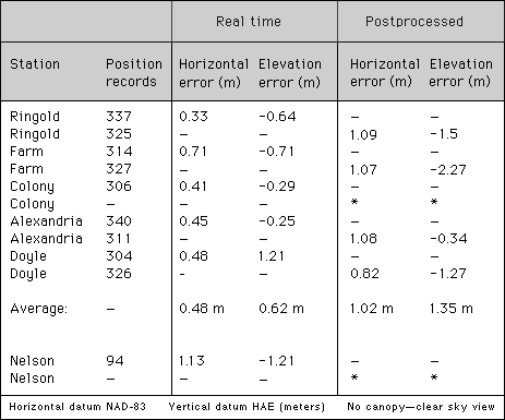
Six first-order or higher geodetic control points were selected as the test stations. They were all located in the open with no obstruction to the satellite signals. All stations were within about 217 kilometers (135 miles) from the Vicksburg Continuing Operating Reference Station. It is assumed the ProBeacon was receiving corrections from this station because it was the closest one to the test site and the ProBeacon was set to receive from any station. The differential correction interval was about 3 seconds.
The 3-second interval is an estimate based on the Vicksburg station's broadcast of a pseudo-range correction for each of a given set of three visible satellites about every second (using the RTCM-SC-104 standard format). If nine satellites were visible and usable, it would take about 3 seconds to send the corrections for all nine satellites, before the station started with the first set again.
The ProBeacon is a radio receiver capable of receiving real-time DGPS correction broadcast from marine radio beacons. It is designed to provide these corrections in the RTCM-SC-104 standard format to any compatible DGPS receiver (such as the Pro XL used in the test). These radio beacons are part of the Continuous Operating Reference Stations network. They are located along the United States Coastal Confluence Zone and on major waterways.
 |
| Figure 1-A Trimble Pro XL GPS receiver (antenna on pole) was used with a ProBeacon marine radio beacon (antenna in backpack) when testing real-time differential GPS (DGPS) positioning. |
After the real-time data were collected at each station, the ProBeacon
was turned off. The Pro XL collected position data for the postprocessing
DGPS comparison. About 300 position records were collected at each station
in a point file for postprocessing. Base station data for this process were
collected at 5-second intervals using a Trimble 400SE single-frequency receiver
located on a nearby National Geodetic Survey control station. The differential
corrections were obtained using MCORR300 differential software. The average
position value for each station was compared to the known value for that
station. The horizontal error and vertical error (antenna height accounted
for) are shown in Table 1.
| Table 1--Real-time position error compared to postprocessed DGPS (MCORR300) position error using the Trimble Pro XL GPS receiver and the Trimble ProBeacon marine radio beacon receiver. |
 * Arbitrary decision not to collect data.
|
A possible reason why the real-time DGPS was more accurate is that the Continuous Operating Reference Station is a dual-frequency receiver (able to solve for the ionospheric and tropospheric errors). The base station used for postprocessing was a single-frequency receiver that relies on an algorithm. Also, the MCORR300 software is an older version of differential software. Both factors could account for the poor performance of the postprocessed DGPS results.
The Continuous Operating Reference Stations are located only along the coastline and major waterways. They do not cover much of the National Forests. Other real-time DGPS services are available on some local FM radio stations, but the broadcasts are easily attenuated by terrain. The U.S. Department of Transportation, Federal Aviation Administration, is planning on a Wide Area Augmentation System that would provide DGPS correction by geostationary communication satellites to commercial airlines and others in the near future. When implemented, this source of differential correction should be evaluated for Forest Service use. It may eliminate the problem of terrain attenuation (when hills block the differential correction signal).
Hard copies of this document may be ordered from:
USDA Forest Service, MTDC
Building 1, Fort Missoula
Missoula, MT 59804-7294
Phone: (406) 329-3719
For further technical information, contact:
Missoula Technology Development Center
Phone: (406) 329-3922
Fax: (406) 329-3719
Email Document Request