
Overview & Applicability
The Seedlot Selection Tool (SST) is a web-based mapping application designed to help natural resource managers match seedlots (seed collections from a known origin) with planting sites based on climatic information.
Populations of forest trees and other native plants are genetically different from one another and are adapted to different climatic conditions. Therefore, natural resource managers must match the climatic adaptability of their plant materials to the climatic conditions of their reforestation or restoration sites. For forest trees, and increasingly for other native plants, this has typically been done using geographically defined seed zones or seed transfer rules that specify a geographic or climatic distance beyond which populations should not be moved. However, these recommendations assume that climates are stable over the long-term—an assumption that is unlikely given projected climate change. Because plant populations are generally considered to be locally adapted, climate change will likely lead to declines in health and productivity of native ecosystems.
Climate-interpolation models are now available that can be used to define zones and transfer limits based on climate rather than geography. The SST can be used to map either current or future climates based on selected climate change scenarios. It allows users to select a transfer limit method (using an established seed zone or creating a customized one), a climate scenario, and a set of relevant climate variables, to map either seedlots that are appropriate for planting on a particular site or sites that are appropriate for a particular seedlot. When future climate scenarios are chosen, the tool allows consideration of seedlots that may be adapted to future climates, a management option often referred to as assisted migration.
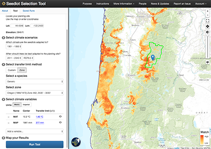 Application display: The SST maps potential seed sources for a planting site while considering potential future climates. Orange areas indicate best suitability for the stated goal given a set of climate constraints
History
Tool development began in 2008 as a collaborative effort between the Department of Forest Ecosystems and Society at Oregon State University and the U.S. Forest Service Pacific Northwest Research Station. The first version was published in the Fall of 2009. However, issues with compatibility with software updates cased difficulties in using the tool. In 2015, we partnered with web programmers at the Conservation Biology Institute to create an updated, more robust version of the tool. The new version was launched in September 2016.
Glenn Howe at Oregon State University and Brad St. Clair at the USFS Pacific Northwest Research Station spearheaded the initial conception and development of this tool. Additional design, software development, and project support were provided by Nikolas Stevenson-Molnar, Brendan Ward, and Dominique Bachelet at the Conservation Biology Institute.
Inputs and outputs
Inputs
Using the Seedlot Selecton Tool involves the following steps:
- Select an objective: Either find seedlots for your planting site or planting sites for your seedlot.
- Select a location: You can click on the map or enter coordinates to locate your planting site or seedlot.
- Select climate scenarios: Choose the climate to which the seedlots are adapted (in the recent past or currently), and the climate of the planting sites that you wish the seedlots to be adapted (looking at the recent past, currently or in the future).
- Select a transfer limit method: You can choose either your own custom limit or use an existing zone to calculate a limit.
- Select climate variables: You can choose from among 16 temperature and precipitation-related climate variables important for adaptation of the species of interest.
- Map your results: The map shows where to find appropriate seedlots or planting sites.
Outputs
A map that highlights the geographical areas that represent appropriate seedlots for a planting site or planting sites for a seedlot. The map reflects the degree of match for the transfer limits from dark orange to light orange.
Restrictions and limitations
The results of the SST are subject to uncertainties that include interpolation of climate to a location, model predictions of climate change, and assumptions of how plants are adapted to their climates. Climate interpolation models and model predictions of climate change are widely accepted and are regularly updated by others to reflect new knowledge and technology. Although the knowledge of plant adaptation to climate varies for different species, one may reasonably assume that temperate plant populations are adapted to cold temperatures and water availability. Users may easily explore the consequences of different assumptions of climate change projections, time periods for adaptation, appropriate climate variables related to adaptation, and appropriate transfer limits. The SST is particularly valuable as a planning and education owing to the ability to explore different parameters.
Currently the tool is limited to the western United States and adjacent Canada and Mexico. Future versions are planned to include all of North America. Furthermore, seed zones and breeding zones are currently available for forest trees in California, Oregon and Washington. Other zones will be incorporated as needed, when time and funding are available. Finally, new climate models will be incorporated as they are updated by others.
Accessing the tool and additional information
More on the tool including detailed instructions are available on the web site: https://seedlotselectiontool.org/sst/