Special Places
Highlighted Areas
Lost Cove Boat Ramp
A great place to launch your boat and spend the day relaxing at Antelope Lake. This site offers restrooms and three picnic tables in the shade next to the water.
Located approximately 2 1/2 miles southeast of Boulder Creek Campground on the north shore of the lake.
Pacific Crest Trail (PCT)
As of Friday, November 18, 2021, all segments of the Pacific Crest Trail through the Plumas National Forest are open.
Detailed information is available at Alerts and Notices on the Plumas National Forest website.
The Pacific Crest Trail spans 2,650 miles from Mexico to Canada. About 75 miles extends across the Plumas National Forest, crossing two major canyons, (the Middle Fork and North Fork of the Feather River). Elevations range from 2400 to 7000 feet. Due to snow at the higher elevations it is usually mid-June before it is feasible to hike in this area. Whether you decide to only hike a short distance of the trail or tackle the entire 2,650 miles, you will experience some of the most breathtaking scenery in the United States.
Butterfly Valley Botanical Area

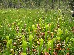
Designated as a botanical area in 1976, the Butterfly Valley is named for its resemblance to a butterfly shape as seen from aerial photos. Located 3.5 miles north of Quincy on Hw 70/89 off of Blackhawk Road, this area includes a Nature Study of 5 species of plants including the California Pitcher Plant, a rare and unusual insect eating plant that only grows in scattered boggy areas from southern Oregon down through northern California. Peak blooming season is May through July. There are also 4 other species of insectivorous plants; 12 species of orchids, 24 species of plants in the Lily family, 9 species of ferns, as well as poppy, buttercup, wild rose and lady slipper.
Indian Valley Area
Just north of Quincy in Plumas County, the Indian Valley includes fishing, hiking, swimming, picnicking and camping in the Plumas National Forest. This portion of Highway 89, just north of Quincy connects two major scenic highway routes. Plumas County's "Scenic Byway Link" travels through the quiet, historic communities of Canyon Dam, Greenville, Crescent Mills, and Taylorsville and is a connection between "Feather River National Scenic Byway" on Hwy 70, just north of Quincy and the “Volcanic Legacy Scenic Byway", which begins at the northern boundary of the Plumas National Forest. This route makes for great scenic driving throughout the year, but is widely known for its spectacular full fall splendor. Also located in the Indian Valley is the Round Valley Reservoir located three miles above Greenville, which is a warm water fishery containing bass and bluegill. It’s a popular place for fishing and picnicking, and is nearby to the Greenville Campground. The area is also great for bicycling.
Bucks Lake Wilderness
The Bucks Lake Wilderness was established by the California Wilderness Act of 1984. The wilderness encompasses 21,000 acres, and is located near the northern end of the Sierra Nevada mountain range.
Topography
Elevations in the Bucks Lake Wilderness range from 2,000 ft. in the Feather River Canyon to 7,017 ft. at Spanish Peak. The top of the escarpment which the Pacific Crest Trail (PCT) crosses unfolds a spectacular view of the forest to the east and north. An impressive view of Mt. Lassen is visible on clear days.
The Bucks Lake Wilderness has a broad diversity of topography and vegetation. Ground cover varies from brush fields to conifer stands, oaks and pure red fir stands. Several small lakes are scattered across the eastern portion of the Wilderness. Along the western slope are small meadows and quaking bogs hidden among the dense stands of red fir.
Black Mountain Lookout

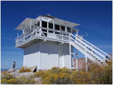
Black Mountain Lookout is situated on the eastern edge of the Beckwourth Ranger District, 10 miles from Highway 395, near Milford, California. The lookout offers striking views of Honey Lake to the north, and Last Chance Creek to the south. Four people can fit in the cabin. Camping space is available outside. Maximum occupancy for the site is eight visitors.
Valley Creek Trail
This trail is closed due to fire hazards in the area. Please see fire use, camping, fire closure area and other restrictions that apply to this site at: Notices & Alerts
The Valley Creek Botanical Special Interest Area contains one of the few remaining examples of Sierra Nevada mixed conifer old growth forest in the Northern Sierra Nevada Mountains. It is located on the Plumas National Forest in southern Plumas County, at an elevation of 4500 to 5000 feet. Bob Cermak, a Forest Service District Ranger in the 1960s, recognized its unique beauty and ecological value, and began the process of designating it as a Special Interest Area. His vision was realized in 1961, when it was officially preserved. In 2011, a 2.5-mile hiking trail was completed, providing access for hikers and nature enthusiasts. The trail is gentle with a few moderately steep sections.
The old growth Douglas-fir and Sugar pine provide habitat for many local wildlife species, including the sensitive California spotted owl and Northern goshawk. They also provide dwellings for small mammals. Valley Creek, which runs through the Special Interest Area, has been recognized as habitat for the sensitive foothill yellow-legged frog and the Federally Threatened red-legged frog.
Little Grass Valley Recreation Area

8-3-2021 At this time the Black Rock boat dock has been removed from the water and is not available until further notice.
The Feather River Ranger District manages 8 family campgrounds around Little Grass Valley Reservoir. There are approximately 323 camping units. Campsites in Red Feather, Running Deer, Little Beaver parts of Loop A & B and the southern half of Wyandotte, and Horse Camp may be reserved through www.recreation.gov (1-877-444-6777) All other campgrounds are available on a first-come, first server basis.
Each campground has piped water. Trailer sites are available, as well as walk-in tent campsites. Trailers of up to 40 feet can be accommodated in some of the camping units. No hookups are provided. There are 2 RV dump stations, one near Tooms Boat Launch, and one near Red Feather. Facilities are usually open from Memorial Day to October.
Little Grass Valley Recreation Area offers opportunities for many more recreation experiences for visitors. Three boat launch ramps provide access to the water for fishing, water-skiing, sailing, or simply touring on boats. There is a wheel chair accessible fishing ramp by at the dam. Two swim beaches provide excellent swimming and picnicking opportunities. The Lakeshore Trail (13 miles) winds around the entire lake, open for horseback riding, mountain bike riding and hiking. Visitors may also enjoy watching wildlife, campfire programs, or exploring nearby historic gold mining towns.
Crocker Guard Station

Refurbished by volunteers so that it can be shared with our visitors, this rustic cabin sleeps 10. It's ideal for a family get together, weddings or special event. No water and no electricity make it a perfect location to get unplugged and relax. Brochure
If your group needs more accommodations, the Crocker Campground is just a hoot and a holler away.


