
Official websites use .gov
A .gov
website belongs to an official government organization in the
United States.
Secure .gov websites use HTTPS
A lock
(
) or https:// means you've safely
connected to the .gov website. Share sensitive information only
on official, secure websites.


Special Places
 From open, vast, high expanses to valleys and canyons that rise steeply to snowy ranges, the Medicine Bow-Routt National Forests encompass portions of five major mountain ranges. Within these ranges are dramatic topographic contrasts: 6,000 foot valleys rise to 12,000 foot peaks. The national forests are located along both sides of the Continental Divide.
Tributaries to the North Platte River and the Colorado River originate on the Routt National Forest. The national forests provide a mix of forested ecology with spruce, lodgepole pine, subalpine fir, aspen, and shrub lands. The Thunder Basin National Grassland is a semi-arid, shortgrass prairie with woody vegetation along rivers. Historic cattle and sheep grazing continues today.
The Medicine Bow-Routt National Forests and Thunder Basin National Grassland support tourism and contribute to the quality of life of residents of nearby communities. There are countless special places throughout the national forests and national grassland. Contact your nearest Forest Service office or visitor center for more information.
-
Fall Colors

Learn about fall colors from across the Medicine Bow-Routt National Forests & Thunder Basin National Grassland, and find the best places near you to see changing colors using the Fall Colors Map.
-
Wilderness

Designated Wilderness areas are managed to preserve their natural conditions and wild character for present and future generations. They possess outstanding ecological, geological, scientific, educational, scenic, or historic values. All or part of ten designated Wilderness areas are located on the Medicine Bow-Routt National Forests!
Highlighted Areas
Fish Creek Falls TH: Trail #1102
NOTE: The bridge at Fish Creek Falls Water Fall is closed until further notice for repairs.
Fish Creek Falls Trailhead #1102 provides a great view of the waterfalls from a wheelchair accessible overlook trail and a dirt trail leading to the base of the falls. A historical bridge, which crosses Fish Creek, continues the trail 5 miles to Long Lake and connects to Trail #1101 and Trail #1032. Vault toilet are provided. Area open year round, providing snow shoeing and ice climbing in the winter months.
Vedauwoo Campground
 The campground is composed of two loops, winding around the boulders, slabs and cliffs of the Vedauwoo rock formation. The formation is made up of 10 square miles of weathered Sherman granite, providing lots of space to explore. There are 28 campsites with tables, fire rings, trash pick up and vault toilets. This area is constructed to blend in with the natural beauty of the surroundings. The vegetation is a variety of Limber pine, Engleman spruce, Douglas fir, and Aspen. Potable water is available inside the RV campground, look for the water pump. There is access to rock climbing and a nature trail through the rocks.
The general area was once used as a hideout for outlaws. Native Americans thought playful spirits piled up the boulders.Some of the campsites are so secluded, one might feel the "outlaw's spirit."
This site was approved for a fee change - Click here for more information
Big Creek Lakes Campground
6/17/2024: Currently there is no potable water, campers should come prepared with their own water. No date has been determined as to when it will have potable water again.
Big Creek Lakes Campground is the most popular campground on The Parks Ranger District and is located an hour drive northwest of the town of Walden, CO. This campground offers 54 campsites and a day-use area and lake-side camping. 24 of the campsites are under the reservation system at www.recreation.gov and the remainder 30 sites are available on a first-come, first-served basis.
The sites are situated next to Big Creek Lake, a scenic lake of 343 acres near the Mount Zirkel Wilderness. There are boating facilities and the lake is a popular destination area for camping and trout fishing. The wetlands around the lake are prime moose territory and moose are often seen near the campground.
Campers should come prepared as summer temperatures are fairly cool at this elevation.
Numerous hiking trails are nearby, both in and out of Mount Zirkel Wilderness. Big Creek Lakes are 35 miles and about an hour drive northwest of Walden, CO. This area has been affected by the mountain pine beetle epidemic and has been logged in recent years.
This site was approved for a fee change - Click here for more information
Brush Creek Visitor Center

Open on weekends in the summer, the Brush Creek Visitor Center is on the Snowy Range Scenic Byway, Hwy 130, near the west Forest boundary. This historic building was built by the CCC. Trailhead parking, a picnic table, toilet facility and a hiking trail are available. Stop and stretch your legs and talk with our knowledgeable volunteers about recreation opportunities in the area!
Bear Lake Campground
The Bear Lake Campground is located 11 miles outside of Yampa, Colorado on Forest Service Road 900. The campground opens annually June 15th (varies with weather). You can find the typical range of outdoor recreation, from fishing and boating, to great hiking and also popular for big game hunting during the fall.
There are 43 campsites (3 double-site and 1 triple-site), vault toilets, potable water, and trash services. The sites are surrounded with a mixed conifer and aspen stand. Though Bear Lake is located outside the campground, the campsites do not offer lake views and only a few have views of the Flat Tops.
(This campground can accomodate trailers up to 30 feet in length. (For those with longer trailers, we recommend the designated camp sites outside the campground which can accomodate trailers up to 40 feet.)
If the campground is full, there are many other camping opportunities outside of the campground along Forest Service Road 900 which leads to the campground. These are designated dispersed sites that cost $10 per night and all offer a picnic table and firegrate.
Free Day Use Area:
The Bear Lake Fishing Pier and Bear Lake Picnic Area are located within a short walk outside of the campground's entrance and are both free of charge for day use only. The lake is popular for trout fishing and can accomodate kayaks, belly boats, canoes and stand up paddle boarding. No camping is allowed at the day use area, however there are plenty of camping opportunities in the immediate area.
This is a free day use area that accesses some great trout fishing and has a large fishing pier with perfect views of the Flat Tops Wilderness. There are 2 picnic tables and fire grates for picnicking. Bear Lake is popular to wade, shore, fly or spin fish.
Boaters should take pre-caution for their own safety by steering clear of the bridge at the dam on the lake for their own safety as there is a spillway that could make it dangerous for those on the water.
No camping is allowed at the day use area.
Additionally, those interested in hiking can access Mandall Lakes, Smith Lake, and Stillwater Trailhead nearby within a short drive along Forest Service Road 900. The trailheads are all clearly marked with a sign and can be seen from the road.
For those requiring a boat launch ramp, we recommend Yamcolo Reservoir which is located just below Bear Lake Reservoir and also offers great trout fishing and also allows motorized boats.
This site was approved for a fee change - Click here for more information
Ryan Park Campground

Ryan Park Campground is located at 8,009 ft elevation on the Snowy Range Scenic Byway near Saratoga, Wyoming. The campground is next to Barrett Creek in the Medicine Bow National Forest and features 49 campsites (13 RV pull-through sites) and 1 group campsite. Sites feature picnic tables and fire grates, and toilets, potable water, and trash services are accessible during the summer season. Pets are allowed but must be kept on a leash no longer than 6 ft at all times.
In addition to exploring the historic sites, visitors can enjoy hiking, mountain biking, fishing, picnicking (also available at nearby Mirror Lake), horseback riding and wildlife viewing.
The Civilian Conservation Corps used this site as a prisoner of war camp in the 1930s. Although little remains, visitors can learn more from the historic interpretive signs at the campground.
This site was approved for a fee change - Click here for more information
South Brush Creek Campground
South Brush Creek Campground is located on the west side of the Snowy Range along the shore of South Brush Creek and is a sunny campground composed of two sections located in a dense stand of Lodgepole pines, fir and Aspen trees next to South Brush Creek. The campground has 20 sites, with 6 pull-through sites for trailers under 25 feet. Amenities include picnic tables, fire grates, toilets, trash service, and a camp host on site, and water is available late May through mid September. Pets are allowed but must be kept on a leash no longer than 6 feet and under control at all times. Many hiking, OHV, and fishing opportunities are available in the area.
This site was approved for a fee change - Click here for more information
Esterbrook Campground
Nestled within a pine forest along a broad ridge, north of Laramie Peak, Esterbrook Campground is a terrific jumping-off point for recreating in the Laramie Peak Unit of the Douglas Ranger District. There are 12 widely separated campsites in a lightly wooded, rocky area, along with 2 vault toilets and potable water. There are 2 non-motorized access spurs from within the campground to the Sunset Ridge Trail and the OHV parking and Trailhead are just 1/2 mile to the west on FSRD 633. Along with the many trails open to all vehicles located within the Esterbrook area, are the Black Mountain Lookout Tower (OHV or walking recommended) and the Harris Park Trail which are located to the south off of FSRD 633.
This site was approved for a fee change - Click here for more information
Stillwater Trailhead

The Stillwater Trailhead offers several hikes into the Flat Tops Wilderness. It is located outside of Yampa, CO at the dead end of Forest Service Road 900. and passes Little Causeway Lake at 1.0 mile. The trail then quickly climbs and reaches the top of the Bear River/Williams Fork Divide at 2.3 miles. Here is where a primitive trail splits off and ascends to the Devil's Causeway.
The following hikes can accessed from this Trailhead:
East Fork Trail #1119
This trail takes you along the north side of Stillwater Reservoir. At mile 0.8 is the split-off to the Bear River Trail #1120 to the left, or stay to the right to stay on this trail. From here, the trail turns north and reaches the Flat Tops Wilderness boundary at mile 1.0. The trail is mostly forested to Little Causeway Lake at mile 1.6. The trail climbs among talus slopes to the Near River/Williams Fork watersheds divide at mile 2.3, where breatking views await you. The trail becomes steep while elevation change is over 1500' making this hike moderate to difficult through a series of switchbacks to the Devil's Causeway. Continuing on, the trail reaches Causeway Lake at mile 5.7. At mile 7.0, find Round Lake and Lost Lakes trail #1116 Junction. From there the trail descends, then crosses and follows the East Fork of the Williams Fork River, intersecting with trail Black Mountain Trail #1117 at mile 8.9.
Further on you will re-cross the river and climb to rejoin with Lost Lakes trail #1116 at mile 11.6 at heading down valley to Transfer Trail #1172 at mile 13.0.
The trail ends at the Pyramid Guard Station at 15.7 miles which pops you out on to the scenic byway, a scenic drive that runs from Yampa to Meeker.
To do the loop; take Lost Lakes trail #1116 to the west, when it intersects with trail West Lost Lakes trail #1103, continue on to the Chinese Wall trail #1803 south back to Bear River trail #1120 which will take you back to the Stillwater trailhead.
Bear River Trail #1120 – This 3.3 mile trail begins at the registration/information board off the East Fork Trail. The trail follows the Bear River up into the Flat Tops Wilderness and reaches Mosquito Lake at 1.5 miles. The trail then climbs before reaching 11,400 feet and ends at the junction with the Little Trappers Lake Trail No. 1814 and the Chinese Wall Trail No. 1803.
North Derby Trail (Hooper & Keener Lake) #1122 – This 2.2 mile trail crosses the Stillwater Dam and enters the Flat Tops Wilderness. After passing some ponds, the trail begins to quickly ascend towards the ridge. At 11,200 feet the trail ends at the junction with the Edge Lake Trail No. 1879 and the Hooper Lake Trail No. 1860. The Hooper Lake Trail gives access to Hooper and Keener Lakes.
There is no camping allowed within ¼ mile of Hooper and Keener Lakes.
No camping or campfires within 100ft of all streams, lakes, and trails.
The alpine vegetation in the Flat Tops is very fragile, PLEASE do not take short cuts and stay on the trail as this causes more resource damage.
Mirror Lake Picnic & Fishing Site

Mirror Lake is a popular picnic and fishing stop on the Snowy Range Highway. The site offers 15 picnic tables with scenic views near the base of Medicine Bow Peak. It provides lakeside access for fishing and a short, paved walking trail to the West Lake Marie Trailhead. Other popular hiking trails in the area include the Medicine Bow Peak, Lake Marie Falls, Lakes Trail and Miners Cabin Trails. This site should not be missed if you are traveling along the Snowy Range Scenic Byway. No services mid-September through June.
This site was approved for a fee change - Click here for more information
Lincoln Park Campground
This campground is three miles off the Snowy Range Scenic Byway (Hwy 130) beside North Brush Creek. Lincoln Park campground is situated at 7,800 feet elevation and offers a great base camp to explore the Medicine Bow National Forest. It includes 12 campsites suitable for trailer, tent, and RV camping. Sites include picnic tables and fire grates, and potable water, toilets, and trash services are accessible during the open season.
Stump Hollow Trail, Cedar Creek Trail, and Kennaday Peak are popular OHV destinations and trails nearby. Kennaday Peak offers a panoramic view of the area. To plan your trail riding, check out the Motor Vehicle Use Map to ensure that you ride safely and legally.
Other activities include fishing in nearby streams that support populations of brook and brown trout. Hiking, horseback riding, mountain biking, hunting, picnicking, winter sports, and wildlife viewing opportunities abound in the Snowy Range area.
This site was approved for a fee change - Click here for more information
La Prele Guard Station
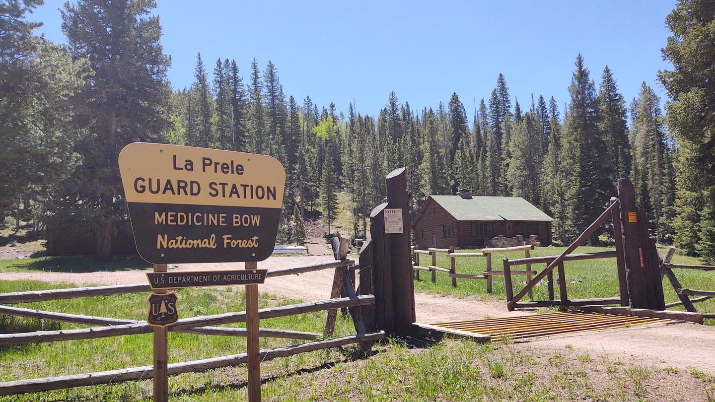 This is part of a district compound built by the Civilian Conservation Corps in 1936 to house the LaPrele District Ranger and is on the National Register of Historic Places. The Guard Station is the only building available for rent at this time. It offers 2 bedrooms that sleep up to 6 people, a full bath, large kitchen and living/dining room with a stone fireplace. There is limited electricity to the cabin, as well as a propane water heater, refrigerator and stove, and the fireplace is adequate for heating the cabin.
All cleaning supplies are provided, but you need to bring bedding and towels, and it's customary to bring additional drinking water. We ask that you pack your trash out and clean the cabin upon departure.
This site was approved for a fee change - Click here for more information

Highlights