
Official websites use .gov
A .gov
website belongs to an official government organization in the
United States.
Secure .gov websites use HTTPS
A lock
(
) or https:// means you've safely
connected to the .gov website. Share sensitive information only
on official, secure websites.


Special Places
There are many special places on the Klamath National Forest but anyone who has ever been in one of the four designated wilderness areas will tell you that here are the greatest views and solitude you'll ever find. For unbelievable diversity and sheer numbers of species of plants, the Klamath ranks near the top for California. And for those who are fascinated by the geology of northern California, the Klamath has 15 very special, world class, Geologic Areas to explore.
-
Wilderness Areas

Klamath National Forest is privileged to manage parts of four different Wilderness Areas within the forest boundaries.
-
Botanical Areas

The Klamath National Forest is home to a unique diversity of plant species. Many are rare and/or endemic, and some have very limited distribution. As such, the places set aside as Botanical Areas deserve our consideration and extreme care when visiting them. Please stay on trails and never pick flowers or take samples.
-
Geologic Areas

Fifteen geologic areas have been identified and defined within the Klamath National Forest. Some are accessible by gravel roads, but hiking is required to reach most.
Highlighted Areas
Klamath National Wild & Scenic River

The Klamath River was designated a Recreational River within the National Wild & Scenic Rivers System in 1981. The Klamath River enters California from Oregon just north of the Goosenest Ranger District. As it heads west it is impounded by two dams which form Copco Lake and Iron Gate Reservoir. Nine miles further west it turns south and follows Interstate 5 for a few miles before again turning west and entering the Happy Camp/Oak Knoll Ranger District. The next 85 miles provide many opportunities for recreation and scenic vistas before the river enters the Six Rivers National Forest. This is a high-use recreation zone. Human waste must be packed out. A scat machine is available in Happy Camp for disposing of collected human waste.
Our interactive river map will help you plan your river trip. It includes information on put-ins and take-puts, rapids, and potential camping sites. You will need to download Google Earth to view the map. You can also book a river trip with one of our permitted outfitters.
Before you start your river trip please complete a trip documentation card. Trip cards are available at river access sites, and may be turned in at the Happy Camp Ranger District office or dropped into one of the trip card boxes available at put-ins. The trip cards help Forest Service staff estimate river use, help us focus our limited staff resources on busier river sections, and help us know if boaters are on a river section if the need for an emergency evacuation arises.
Sections of the Klamath River downstream from Happy Camp are subject to temporary river use restrictions during the summer in observance of Karuk Tribal ceremonies. Please refer to the current schedule for information on the current year's river access restrictions. 2021 Klamath River Closures for Karuk Tribal Ceremonies
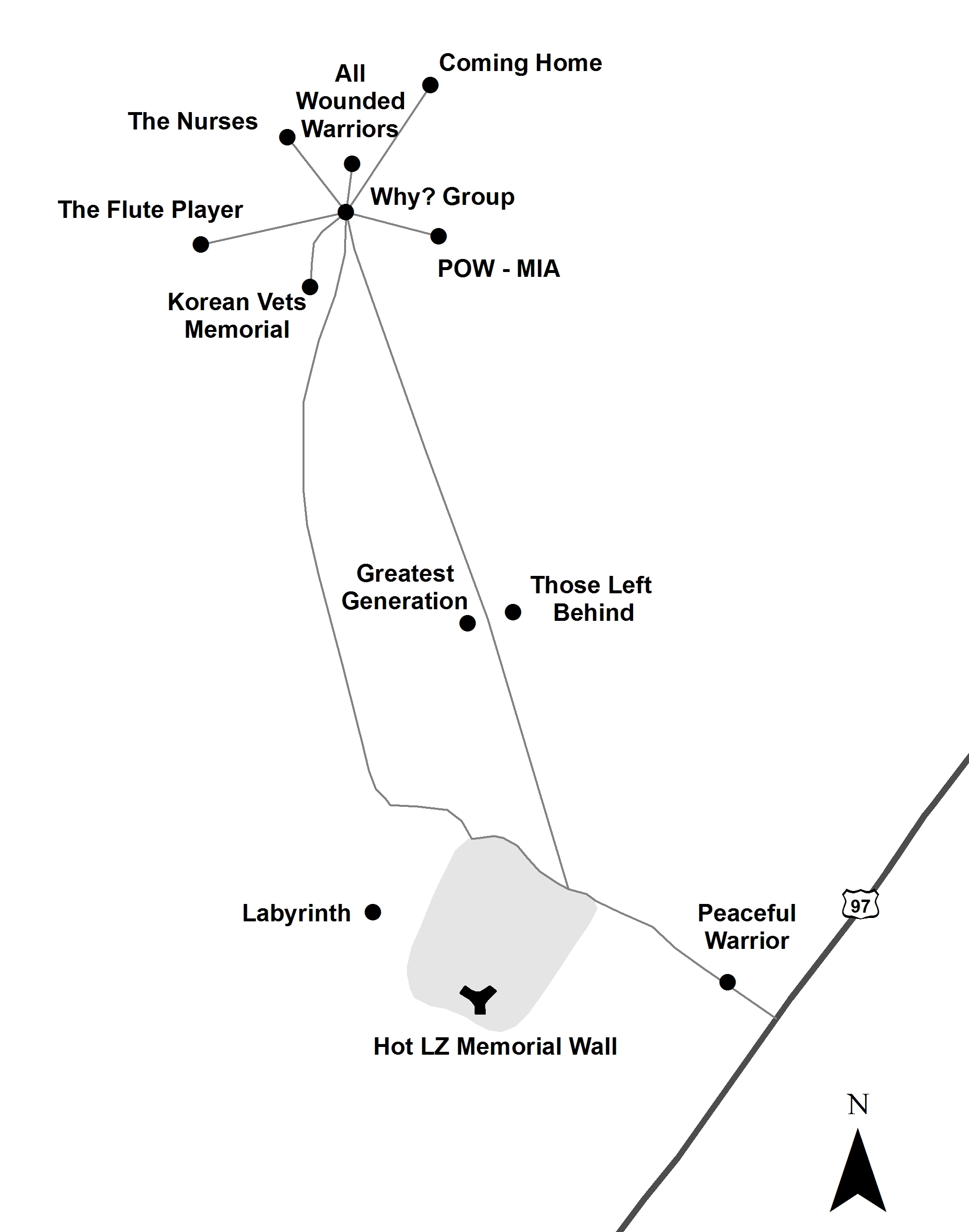
Living Memorial Sculpture Garden

The Living Memorial Sculpture Garden is an exceptional 136-acre art installation and war memorial along Highway 97 on the Goosenest Ranger District of the Klamath National Forest. Created in 1988 by a dedicated group of veterans, the site is now maintained under an agreement with the USDA Forest Service.
The site includes the Hot LZ Memorial Wall, The Labyrinth, and ten sculptures by artist Dennis Smith.
The Living Memorial Sculpture Garden is located on the west side of Highway 97, 0.9 mile north of the intersection with the A-12 Road, 13 miles north of weed, and 27 miles south of Macdoel. Please note there is no water, no restroom, and no garbage service. The Grass Lake Rest Area is located 8.6 miles north on Highway 97.
For more information, please visit the Living Memorial Sculpture Garden web site at www.lmsgarden.org.
Humbug OHV Recreation Area
The Humbug OHV Area, located on the Happy Camp/Oak Knoll Ranger Districts, provides riders with 14 miles of trails (open to vehicles 50 inches or less in width), a youth riding area, and 5 acres of open riding terrain. It has a day use parking area, picnic tables, two campsites, vault toilets, and a loading/unloading ramp. In addition, the Happy Camp/Oak Knoll Ranger Districts offer 695 miles of road open to OHV use. For details about roads open to off-highway vehicles please pick up a current copy of the Klamath National Forest Motor Vehicle Use Map, which is available free of charge at all Klamath National Forest Offices and is available on-line at www.fs.usda.gov/klamath.
Always be sure to wear proper safety gear and make sure your vehicle has the appropriate tags from the California Department of Motor Vehicles.

