Official websites use .gov
A .gov
website belongs to an official government organization in the
United States.
Secure .gov websites use HTTPS
A lock
(
) or https:// means you've safely
connected to the .gov website. Share sensitive information only
on official, secure websites.


Dispersed Camping
Quick Links
More Details
While much of the Forest is open to dispersed camping, there are several sites set aside as designated dispersed camping sites, listed below. Pick up or download a free Motor Vehicle Use Map to know where it is legal to drive. See Guidelines for information and policies, and Specific Sites for more details and contact information.
Know before you go! Be aware extreme winter weather or flooding risks can necessitate the closure of forest roads at different times of the year. Many forest roads that lead to dispersed campsites may be closed during seasonal road closures, so please check the Forest Road Status web page for more information about the status of forest roads in each District.
Fire restrictions may be in place. During fire restrictions, campfires, fires, and charcoal fires are not permitted in dispersed camping areas. This includes both Stage 1 and Stage 2 Fire Restrictions. Gas operated devices with an on/off switch are allowed. Where can I have a campfire during Stage I Fire Restrictions?
Areas Closed to Dispersed Camping
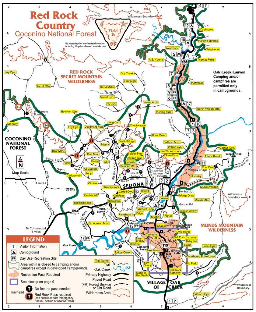
- Sedona and Oak Creek Canyon: Dispersed camping is prohibited in the "pinkish-salmon" colored boundary shown on the Red Rock Country recreation map (JPG, 2.1 MB). The Sedona Area Dispersed Camping flyer (PDF, 760 kB) contains maps of recommended dispersed camping areas.
- Stage Stop: located on Highway 179, approximately 2 miles north of the junction of Highway 179 and I-17.
- Mormon Crossing/Springs: west of the Page Springs Road (County Road 134), and west of the fish hatchery and school.
- Fossil Creek Area: the Fossil Creek Area recreation map and regulations (PDF, 1 MB) outlines areas where camping is prohibited.
- FR 237 and Kelly Pocket Area: between SR 89A and I-17 south of Kachina Village, except in specific sites along the southwestern end of FR 237 (PDF, 910 kB).
See Forest Orders for information and maps of these and other closures.