Regional Banner - Mountains covered in snow with a green bar on top Click link to view the Rocky Mountain Region website United States Department of Agriculture (USDA) logo and link to the USDA website Click link to view the United States Forest Service website United States Forest Service (USFS) logo and link to the USFS website
 
Forest Service Home
 
About the Agency
 
Contact the National Office
 
 
Banner with trees and snow
Animated Christmas tree with presents around the bottom
Regional Christmas Tree Program (RCTP)
Colorado Cutting Areas Information Map
Banner with trees and snow
 
To return to the RCTP Home page or Recreation Home page, select from the dropdown menu to the right:
 
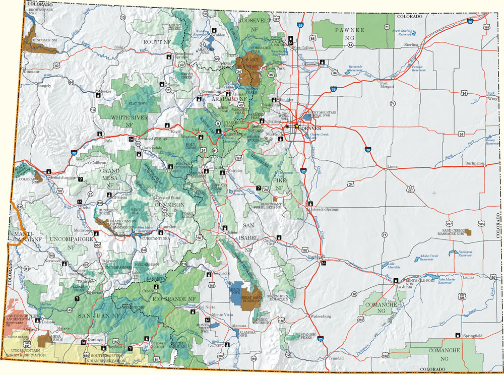
The green areas on the state map below show the boundaries of the 11 national forests and two national grasslands within Colorado. To view Christmas Tree Program cutting information for US Forest Service lands located in Colorado, move your cursor over a national forest or grassland you are interested in. Once you are on top of the national forest or grassland, a filled-in map outline and tool tip will appear. Click the cursor on the green map outline and a link will open to that national forest or grassland's Christmas Tree Program Information webpage.
 
NOTE: The region's primary Christmas tree cutting dates this year will be December 3-11, 2016, which means that all tree cutting areas in our region must be open between those dates. Tree cutting dates will vary from one cutting area to another. Some areas allow cutting as early as Thanksgiving and some allow cutting until the end of the year. You will have to check with your area's Christmas Tree Program Information webpage for exact cutting dates!
 
Front Range/Denver Metro Cutting Areas Map - Click to view a link to the Front Range/Denver Metro Cutting Areas webpage  
For folks that are only interested in finding the Christmas tree cutting areas closest to the Front Range/Denver Metro Area, you can click on this Front Range/Denver Metro Cutting Areas link or on the small Front Range map to the left. You will then be taken to the Front Range/Denver Metro Cutting Areas webpage which shows the cutting areas closest to (north to south) Ft. Collins, Denver and Colorado Springs.


Colorado Christmas Tree Program Information Map Intermountain Region (R4) - Click on the map outline to view the Intermountain Region Christmas Tree Program Information web page in a new window Rio Grande National Forest (NF) - Click on the map outline to view the Rio Grande NF Christmas Tree Program Information web page in a new window San Juan National Forest (NF) - Click on the map outline to view the San Juan NF Christmas Tree Program Information web page in a new window Uncompahgre National Forest (NF) [Mountain Division] - Click on the map outline to view the Uncompahgre NF Christmas Tree Program Information web page in a new window Uncompahgre National Forest (NF) [Plateau Division] - Click on the map outline to view the Uncompahgre NF Christmas Tree Program Information web page in a new window Gunnison National Forest (NF) - Click on the map outline to view the Gunnison NF Christmas Tree Program Information web page in a new window Grand Mesa National Forest (NF) - Click on the map outline to view the Grand Mesa NF Christmas Tree Program Information web page in a new window San Isabel National Forest (NF) - Click on the map outline to view the San Isabel NF Christmas Tree Program Information web page in a new window Comanche National Grassland (NG) [managed by the Pike & San Isabel NFs] - Click on the map outline to view the Comanche NG Christmas Tree Program Information web page in a new window Pike National Forest (NF) - Click on the map outline to view the Pike NF Christmas Tree Program Information web page in a new window Arapaho National Forest (NF) - Click on the map outline to view the Arapaho NF Christmas Tree Program Information web page in a new window White River National Forest (NF) - Click on the map outline to view the White River NF Christmas Tree Program Information web page in a new window Pawnee National Grassland (NG) [managed by the Arapaho & Roosevelt National Forests (NFs)] - Click on the map outline to view the Pawnee NG Christmas Tree Program Information web page in a new window Roosevelt National Forest (NF) - Click on the map outline to view the Roosevelt NF Christmas Tree Program Information web page in a new window Routt National Forest (NF) - Click on the map outline to view the Routt NF Christmas Tree Program Information web page in a new window
 
To return to the RCTP Home page or Recreation Home page, select from the dropdown menu to the right:


https://www.fs.usda.gov/Internet/FSE_DOCUMENTS/stelprdb5398072.html