
Official websites use .gov
A .gov
website belongs to an official government organization in the
United States.
Secure .gov websites use HTTPS
A lock
(
) or https:// means you've safely
connected to the .gov website. Share sensitive information only
on official, secure websites.


Quinault Rain Forest Nature Trail #855
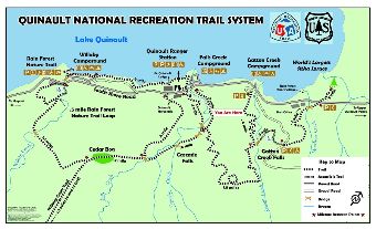
Quinault National Recreation Trail System vicinity map.

This heavily used 1/2 mile interpretive trail provides an excellent opportunity to view the temperate rainforest. Overlooking Willaby Gorge, the trail follows Willaby Creek, a typical rainforest stream. Experience stands of ancient large trees and view intepretive signs along the trail that describe aspects of oldgrowth forest ecology.
The trail is compacted gravel and first 850 feet is accessible to individuals in wheelchairs.
To view all segments of the Quinault National Recreation Trail System and learn more explore the Quinault National Recreation Trail System interactive map.
At a Glance
| Current Conditions: | Open |
|---|---|
| Usage: | Medium-Heavy |
| Closest Towns: | Aberdeen, WA |
| Restroom: | Flush Toilet (1) at trailhead |
| Passes: | A valid Recreation Pass is required at Quinault Rain Forest Trailhead. |
| Operated By: | Forest Service |
| Information Center: | Pacific Ranger District-Quinault office |
General Information
Directions:Trail access from Quinault Rain Forest Trailhead.
From Aberdeen, WA travel north on US Highway 101 for 45 miles to the junction of South Shore Road. Turn right (east) and drive 1.4 miles to Quinault Rain Forest Trailhead on right side of South Shore Road.
Accessibility:
Interpretive area with views of the lush Quinault Rain Forest on the edge of Willaby Creek Gorge.
