
Official websites use .gov
A .gov
website belongs to an official government organization in the
United States.
Secure .gov websites use HTTPS
A lock
(
) or https:// means you've safely
connected to the .gov website. Share sensitive information only
on official, secure websites.


Trail #228 Covel Creek
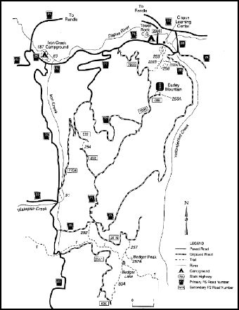
Burley Area General Map in the Cowlitz Valley Vicinity. Sites include:
Angel Falls Loop Trail #228B
Badger Ridge Trail #257
Boundary Trail #1
Burley Mountain Lookout
Burley Mountain Trail #256
Covel Creek Falls Trail #228A
Covel Creek Trail #228
French Butte Trail #254
Iron Creek Campground
Iron Creek Falls Trail #91
Iron Creek Old Growth Trail #83
Iron Creek Campground Loop Trail #187 Mosquito Meadows Trail #292
This trail is open to hiker use only.
Take the family on a short hike through a beautiful mixed hardwood and conifer forest along Covel Creek. The trail is used by the Cispus Learning Center for nature study. This low elevation trail makes for a great winter hike.
The trail ties in with the Covel Creek Falls Trail #228A, Angel Falls Loop Trail #228B, Burley Mountain Trail #256 and the Cispus Braille Trail.
At a Glance
| Current Conditions: | 6/24/24: July 8th - July 26th, a road closure on FR76 from Milepost 0 to Milepost .76 for a culvert replacement |
|---|---|
| Restrictions: | This trail is open to hiker use only and is closed to all other uses. |
| Closest Towns: | Randle, WA; Packwood WA |
| Water: | No |
| Restroom: | No |
| Operated By: | Forest Service |
| Information Center: | Cowlitz Valley Ranger District |
General Information
Directions:From Randle, Washington travel south on State Highway 131 (Forest Roads 23 and 25). Veer left in 1 mile at the Y of Forest Road 23 and Forest Road 25. Continue to follow Forest Service Road 23 for 8.1 miles to the junction of Forest Road 28. Follow Forest Road 28 for 1.4 miles and turn right on Forest Road 76 . Follow Forest Road 76 for .7 miles. The trailhead is across from the entrance to the Cispus Learning Center.