
Official websites use .gov
A .gov
website belongs to an official government organization in the
United States.
Secure .gov websites use HTTPS
A lock
(
) or https:// means you've safely
connected to the .gov website. Share sensitive information only
on official, secure websites.


Wahkeena Falls

Wahkeena Falls is day use area and trail situated at the base of beautiful Wahkeena Falls, just west of Multnomah Falls on the Historic Columbia River Highway. One of stops along the famed waterfall area on the Historic Highway, it connnects with a network of trails that make for great day hike loop opportunities, and world-class scenery. The 242-foot falls is a tiered type of waterfall, named after the Yakama word for "most beautiful". While not as tall as nearby Multnomah, it is no less lovely.
Wakheena Falls and several trailheads are located south of the highway, where an accessible overlook provides a prime view and photo opp for visitors. Nearby trailheads include Wahkeena Trail #420, Gorge #400 Trail, and a short Return Trail that can be used to hike to nearby Multnomah Falls.
Amenities at the picnic area (north of the highway) include a large picnic shelter with a stone fireplace, along with accessible picnic tables and fire rings.
Many people ask about reservations for weddings. This is a first-come, first-served area. If the group will be larger than 75 people, a special use permit is required.


At a Glance
| Current Conditions: | Gates and restrooms closed. opens 5/1/24. |
|---|---|
| Reservations: | No reservations accepted - first come, first serve basis for picnic area and shelter. |
| Fees: | No Fee |
| Permit Info: | Weddings, commercial uses, and any group events with more than 75 people require a special use permit. |
| Open Season: | Year round |
| Usage: | Medium-Heavy |
| Restrictions: | Aircraft/UAS/drone takeoffs and landings are prohibited at this site. |
| Closest Towns: | Troutdale, OR |
| Water: | No Water |
| Restroom: | Flush toilets |
| Operated By: | Forest Service |
| Information Center: | Columbia River Gorge National Scenic Area |
General Information
Accessibility:The picnic area and waterfall overlook are both ADA accessible, unless winter conditions (ice and snow) are present. (The paved surfaces are not routinely cleared in winter.) View a video about accessibility upgrades to this site in 2014.
Directions:
From Portland, OR: Travel east on I-84 for ~30 miles, then take Exit #28, Bridal Veil. Turn left from the off ramp onto the Historic Columbia River Highway. Travel 2.5 miles east to the site's parking area along the north side of the Highway. The trail starts on the Highway's south side.
From Cascade Locks, OR: Travel west on I-84 to Exit #35, Ainsworth State Park. Follow the Historic Highway west 4.5 miles to the site's parking area.
From Stevenson, WA: Head south on WA-14 for 2 miles, then cross the Bridge of the Gods (toll applies). Head left onto Wa Na Pa Street, which merges onto the westbound ramp of I-84. Travel west to Exit #35, Ainsworth State Park. Follow the Historic Highway west 4.5 miles to the site's parking area.
From Vancouver, WA: The first option is to cross the Columbia River on the I-205 bridge, then head east on I-84, following the directions from Portland, OR. A more scenic alternative is to take WA-14 east to the Bridge of the Gods (toll applies). From the bridge off-ramp, head left onto Wa Na Pa Street, which merges onto the westbound ramp of I-84. Travel west to Exit #35, Ainsworth State Park. Follow the Historic Highway west 4.5 miles to the site's parking area.
General Notes:
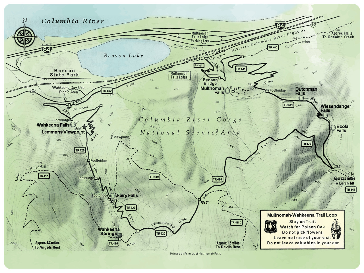
Download or Print a Multnomah-Wahkeena Loop Trail Vicinity Map:
Activities
Day Hiking
Near the trailheads for the Wahkeena Trail #420 and the Gorge #400 Trail.
Areas for Day Hiking at Wahkeena Falls
Viewing Scenery
Not only is there Wahkeena Falls to witness, but also notice the historic architecture of the historic highway and the stonework of an era gone by.
Areas for Viewing Scenery at Wahkeena Falls
Picnicking
Accessible tables on site
| No. of Sites | 14 |
| Reservation Info | None |
| No. of Accessible sites | 14 |
Group Picnicking
Accessible picnic tables and fire rings in open and covered setting. Several tables inside CCC style picnic shelter.
| No. of Sites | 12 |
| Reservation Info | First-come, first-served basis |
| Group Shelter | CCC style shelter with accessible tables |
| Group Cooking Facilities | No |
| Fire Information | Fire stoves and stands are on site |
| Hookups - Electric | No |
| No. of Accessible sites | 12 |


Related Information

Highlights
Location