

Helene
Hurricane Helene
On September 27, 2024, Hurricane Helene moved through the mountains of Western North Carolina resulting in one of the worst disasters in the area's recorded history. Heavy winds and rainfall had an unprecedented impact on the region, particularly impacting the communities in and around Pisgah National Forest.
Our partners at the National Forest Foundation created a story map to describe the vast damage and impacts caused by Hurricane Helene.
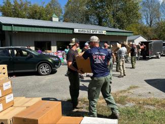
US Forest Service Fire crews help unload relief supplies following Hurricane Helene.
USDA Forest Service photoAftermath on the National Forests in North Carolina
Using satellite data, aerial surveying and on-the-ground assessments, our data found that Hurricane Helene cause moderate-to-catastrophic damage on more than 190,000 acres of National Forest land.
Additional impacts included:
- 885 miles of roads severely impacted, with 30% of roadbeds completely destroyed
- An estimated 48 road bridges damaged or destroyed
- 43 major culverts in need of restoration
- Approximately 850 miles of trails damaged, including 171 miles of the Appalachian National Scenic Trail
- Nearly all recreation sites on the Pisgah National Forest received some level of damage, with several catastrophically damaged.
In the months following the storm USDA Forest Service crew and partner organizations have made progress in clearing trails and reopening roads and recreation areas. Crews continue to work throughout the Pisgah National Forest. The public should use extra caution when visiting the area and be aware of current closure orders.
Volunteering
Explore volunteer opportunities with our partners who are actively supporting recovery efforts in Pisgah National Forest. These dedicated organizations are assisting with storm-related assessments, cleanup, and fundraising. We are deeply grateful for their commitment and for the many individuals who have devoted their time, money, and resources to support our forests.
Organizations Accepting Volunteers:
•The Pisgah Conservancy
•Naventure
•FIND Outdoors
•Carolina Mountain Club
•Back Country Horsemen of Pisgah
•Carolina Climbers Coalition
•Trout Unlimited
•Transylvania County Extension Master Gardeners
•Pisgah Area SORBA
•Waterfall Keepers of North Carolina
Closures
Closure order and press release
*Edit to press release: Elk Falls has since opened
For updates and current conditions contact the Appalachian Ranger District:
(828) 689-9694
OPEN-
Haywood and Madison
All trails are open
Yancey and Buncombe
Big Butt Trail from the Highway 197 trailhead (Cane River Gap) to the Little Butt viewpoint.
The portion of this trail from the Little Butt viewpoint to the Blue Ridge Parkway trailhead is closed.
Roan Mountain
Cloudland Trail
Roan Mountain Gardens Trail including Loop A and B
Roan Mountain Road & Balsam Road
Appalachian Trail
I-40 to Indian Grave Gap (milepost 241.3 to 351.8)
Hughes Gap to Carvers Gap to Doll Flats (milepost 373.1 to 390.9)
Appalachian Trail Detour – Iron Mountain Gap
The Iron Mountain Gap detour is now in place to route hikers around the final remaining closed section of the
Appalachian Trail from about a mile south of the destroyed Cherry Gap Shelter to about a mile north of Iron Mountain Gap
(approx. NOBO mile 360.6 to 365.9).
REMAINING CLOSED-
Mitchell County Trails & Roads
- Poplar Boat Launch Road
- Appalachian Trail
- Indian Grave Gap to Iron Mt. Gap
- Iron Mt. Gap to Hughes Gap
Buncombe County
- Mountains to Sea Trail
- Ogle Meadows Road
- All trails and roads within the Big Ivy and Shope Creek areas.
Yancey County
- All trails and roads within the South Toe/Mt. Mitchell areas.
- Lost Cove Trail
- Devils Creek Trail
- Bowlens Creek Road
- Hunt Camp Road
Haywood County
- Haynes Road (Hurricane Creek)
- Buzzard Roost Road
- Old Buzzard Roost Road
RECREATION SITES-
Harmon Den Campground will open in May during its regular open season (May thru October).
The following developed recreation sites and campgrounds remain closed due to damage from Helene:
- Black Mountain Campground
- Briar Bottom Campground
- Poplar Boat Launch
- Roan Mountain Recreation Area
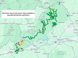
Trail Updates provided by G5 Trail Collective
For updates and current conditions contact the Grandfather Ranger District:
(828) 652-2144
The following recreation sites and trails remain closed:
McDowell County:
- Curtis Creek Campground
- Gateway Trailhead (trails are open)
- Bernard Mountain Trailhead (trails are open)
- Lower Heartbreak Ridge Trail (TR207)
- Curtis Creek Fishing Access (TR1110)
- Newberry Creek Trail (TR210)
- Snooks Nose Trail (TR211)
- Hickory Branch Trail (TR213)
- Sugar Cove Trail (TR219)
- Portions of the Meadows Loop Trail (TR1107 - see map)
- Section of the Mountains to Sea Trail where it crosses the North Fork River (bridge out)
Burke County:
- Table Rock Picnic Area (trails are open)
- Sections of the Linville Gorge Trail (TR231 - see map)
- Greentown Shortcut Trail (TR268A)
Caldwell County:
- Wilson Creek Gorge Day Use Area (no activities permitted in area during closure)
- Harper Creek Trail (TR260)
- Wilson Creek Trail (TR258)
- Wilson Creek Spur Trail (TR258A)
The following roads remain closed to motorized vehicles, but are open to recreational us on foot, bike and horseback:
McDowell County:
- Curtis Creek Road (FSRD482 - gated below campground)
- Jarrett Creek Road (FSRD4030 - gated before Gateway Trailhead – bridge out)
Burke County:
- New Gingercake Road (FSRD496)
- Table Rock Road (FSRD99 – paved section to Table Rock)
Caldwell/Avery Counties:
- Thunderhole Road (FSRD4071)
- Lost Cove Road (FSRD 464A)
The following roads in McDowell County are not passable, even for non-motorized traffic because of extreme damage. Use of these roads on foot, bike or horseback is not recommended:
- Newberry Creek Road (FSRD482A)
- Sugar Cove Road (FSRD1188)
- Good Cemetery Road (FSRD4008)
- Little Buck Road (FSRD470)
- Parris Creek Road (FSRD1186)
For updates and current conditions contact the Pisgah Ranger District:
All trails in Pisgah Ranger District are open. Many have storm damage and hazards may include washed-out bridges, tripping hazards, landslides, eroded areas, muddy or slick footing, and downed trees.
Current Road Closures:
- #475B – Headwaters (lower end)
- The lower end from Davidson River Rd to Sunwall Trailhead is closed, upper end is open.
- #477 – Avery Creek
- Phase 1 repairs are estimated to be completed this week.
- The lower end from SR 276 to the Pisgah Riding Stables will reopen soon.
- #471 - Cathey’s Creek
- The Upper end will reopen soon.
- #140 – Courthouse Creek
- #229 – Pilot Mountain
- #1206 - Yellow Gap
- Closed from Wolf Ford CG to North Mills River CG.
Planned Road Closures:
- Sporadic closures as needed throughout the summer for annual road maintenance.
- #471 - Cathey’s Creek
- Emergency repairs above Cathey’s Creek Falls and near the City of Brevard Water Intake. Sporadic closures as needed.
Things to Know:
- Construction on two bridges on Davidson River Road (#475) near Cove Creek will begin late summer/early fall.
- The new English Chapel Bridge is estimated to be delivered in June. Work will begin on new abutments late June.
Please note: although #477 Avery Creek Rd is closed to motor vehicles, it is still passable for hiking/biking/foot/horse traffic. Same for #475b Headwaters Rd.
For updates and current conditions contact the Pisgah Ranger District:
(828) 877-3265