Standing on the banks of the Yadkin River in Wilkesboro, North Carolina, the river tumbles peacefully by. The river water has made a long journey: it originated as rainfall deep in the Blue Ridge Mountains of Virginia. It flows through the Uwharrie, Sumter, and Francis Marion National Forests. It travels through Winston-Salem, Charlotte, and Charleston – and into people’s faucets and to farmers’ fields.
Forests naturally filter rainwater. Water from a forest is much cleaner than water from urban or agricultural land. Forests provide drinking water to more than 150 million people in the U.S.
Forests clean drinking water in a variety of ways. First, tree leaves and branches slow rainwater down before it reaches the forest floor, preventing erosion, especially during heavy downpours. Rainwater is then naturally filtered as it moves through the soil. Tree roots keep sediment from reaching streams and absorb nutrients that would otherwise pollute waterways. Even if they are far away from where surface water is pumped to provide supplies, forests help keep drinking water clean and safe.
A new USDA Forest Service project highlights these important connections: Forests to Faucets, version 2.0. The project includes a report and a story map where users can explore data on forests and drinking water.

“Anyone can use the story map to see where forests are threatened by climate change, fire, insects, diseases, and land use change or urbanization,” said Erika Mack, at the time a researcher with the Southern Research Station. “Along with the map, we have published a report that explains how the threats were defined and maps were created.”
Trees and their roots slow water down. But fire, insects, and diseases can kill trees, removing them from the landscape. Without trees, water rushes over the land and pours into streams, which may then flood during heavy rainfall. Trees also protect water quality by keeping soils from washing into streams. Once in a stream, soil is considered a pollutant.
As the climate warms, the amount of drinking water that forests provide may dwindle. Watersheds in the Pacific Northwest and Southern Regions are at a higher threat of reduced water yield because of climate change according to Forests to Faucets 2.0. The Southern, Pacific Southwest, and Eastern Regions had the most watersheds at the highest threat of land use change. The Pacific Southwest, Pacific Northwest, and Northern Regions had the most watersheds at the highest threat from wildfire as well as the most watersheds at the highest threat from insects and disease.
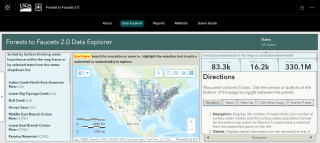
“The Forests to Faucets story map tool shows which watersheds may be vulnerable to these threats in the future,” said Rebecca Lilja, developer of the story map and a data service specialist with State and Private Forestry in the Eastern Region.
Users can select their local watershed, explore watersheds located upstream and downstream, download data, and print reports. Land managers, planners, or other users can see how many people depend on water from a specific forested watershed. The map is a tool that can show land managers how management actions may affect downstream water supply.
The map isn’t just for land managers. Water consumers can use the tool to see their local watershed. They can consider potential threats upstream. They can explore how threats affect water supply and quality in different ways.
“We all live in a watershed, and we can all take care of the lands that provide our water supply,” said Mack.
Find out where your water comes from. Click on this map to connect your community to its water supply and the forest areas providing it. Learn more about the map and dataset in this report and series of how-to videos.